0%

Show Low Lake Fishing Report Today 🎣

7 months ago Β· Updated 1 month ago

Show Low Lake Fishing Report: Spring Transition Tactics and Trophies

Welcome to your comprehensive angler's guide for Show Low Lake. Nestled in the White Mountains at an elevation of 6,500 feet, this 100-acre reservoir is a premier destination for both casual bank anglers and serious trophy hunters. As we move through the spring season, rising water temperatures are triggering heavy feeding windows. Whether you are chasing freshly stocked limits or hunting the next state record, this report delivers the exact tactical intelligence you need to succeed on the water.

1. GO/NO-GO STATUS

Verdict: GO - PRIME CONDITIONS

Current seasonal conditions make this an absolute "GO" for anglers. The lake is entirely free of ice, which is typical for this fishery as it rarely freezes over for extended periods. As the spring sun warms the shallow flats, fish metabolism is shifting into high gear.

From the editor

Tired of fishing with strangers you can’t trust?

Nautrek is the first social network for serious anglers — verified partners, real trips, cost splitting and intel sharing without burning your spots. Private beta now open.

Join the Waitlist — Free → 100+ anglers on the list
Nautrek App

From a weather and safety standpoint, anglers should be prepared for classic high-country spring conditions. Expect crisp, cool mornings transitioning into mild afternoons. Wind is the primary environmental factor to monitor right now; breezy conditions are common and can create a choppy surface. While a light "walleye chop" breaks up light penetration and triggers aggressive feeding, sustained gusts over 15 mph can make boat control difficult. Small watercraft users should exercise caution and utilize the protected coves along the southern shore if the wind picks up.

Pro Tip: Always keep an eye on the barometric pressure during the spring transition. A steadily dropping barometer ahead of a spring squall will often ignite a frantic feeding frenzy, particularly for predatory species.

2. SPECIES INTEL

Show Low Lake boasts a diverse and thriving ecosystem, but two species demand your immediate attention during the spring months.

Primary Target: Rainbow Trout

Rainbow trout are currently the most abundant and active species in the reservoir. The Arizona Game and Fish Department (AZGFD) utilizes an aggressive spring stocking schedule, planting catchable-sized rainbows on a near-weekly basis. These freshly stocked fish are highly aggressive and school tightly. Furthermore, because the lake maintains excellent water quality and depth (averaging 33 feet and maxing out at 50 feet), many trout survive the winter. These "holdover" trout are significantly larger, warier, and fight with incredible vigor.

Sleeper Pick: Trophy Walleye

While most visiting anglers focus entirely on trout, ignoring the walleye population is a massive mistake. Show Low Lake is arguably the greatest walleye fishery in the state of Arizona, having produced the last five state records, including an absolute monster weighing 16 pounds, 2 ounces. Spring marks the pre-spawn period for walleye. During this crucial window, these elusive, light-sensitive predators move out of the deep basins and push into the shallows to feed and prepare for spawning.

Baitfish and Forage Report

To consistently fool mature fish, you must match the hatch. The primary forage base in Show Low Lake consists of crayfish, juvenile bluegill, green sunfish, and threadfin shad. As the water warms, crayfish emerge from their rocky winter hideouts. Predator fish will be actively rooting around rocky structures looking for these high-protein meals.

3. TACTICAL STRATEGY

Success on Show Low Lake requires precision. Leave the generic tactics at home and deploy these specific, guide-level strategies.

Where to Target

  • The Creek Inflow: For pre-spawn walleye and large channel catfish, navigate to the upper end of the lake where Show Low Creek flows into the reservoir. The moving water provides highly oxygenated current and funnels nutrients into the lake, creating a natural ambush point. Focus on the 8 to 15-foot drop-offs just outside the main creek channel.
  • The Dam Face: The riprap and rocky structure along the dam is a magnet for smallmouth bass, sunfish, and cruising walleye. The rocks hold heat from the sun, warming the adjacent water slightly faster than the rest of the lake, which draws in crayfish and the predators that hunt them.
  • Shoreline Access: For trout, the weed-free shorelines near the campground and boat ramp offer excellent access. Cast out toward the first major depth transition.

Lure and Color Selection

For walleye, precision casting with a 1/4-ounce lead-head jig paired with a 3-inch curly tail grub in chartreuse or white is deadly when bounced down the rocky ledges. Alternatively, cast medium-diving crankbaits like a Rapala Shad Rap (Size 5 or 7) in a perch or crawdad pattern. Retrieve these with a jerky, stop-and-go cadence to trigger reaction strikes.

For active trout, throw 1/16-ounce or 1/8-ounce inline spinners. A Rooster Tail or Panther Martin in silver/blue is perfect for clear, sunny days. If spring winds or runoff stain the water, switch to gold blades with dark bodies to maximize contrast.

Bait and Rigging

If you prefer soaking bait, utilize a slip-sinker rig (Carolina rig) to ensure the fish feel zero resistance when they pick up the bait. For stocked trout, float Garlic or Chartreuse PowerBait 18 to 24 inches off the bottom. For walleye and channel catfish, thread a lively nightcrawler onto a size 4 bait holder hook and drag it excruciatingly slowly across the bottom near the dam.

Timing the Bite

Walleye possess highly specialized eyes designed for low-light hunting. If you are targeting them, the golden hours of dawn and dusk are non-negotiable. Mid-day walleye fishing is generally unproductive unless you have heavy cloud cover. Trout, however, will feed aggressively throughout the mid-morning as the sun warms the surface layer.

Pro Tip: When dragging nightcrawlers or jigs through the rocks for walleye, use a 10-pound fluorocarbon leader tied to a high-visibility braided mainline. The braid allows you to detect the subtlest bottom transitions, while the fluorocarbon remains invisible to line-shy fish in the clear mountain water.

4. REGULATIONS SNAPSHOT

Always verify current AZGFD regulations before hitting the water, but here is the critical rulebook snapshot for Show Low Lake:

SpeciesDaily Bag LimitSpecial Notes
Trout (All Species)4 in any combinationIncludes Rainbow, Brown, and Brook Trout.
Walleye6Prime target for spring anglers.
Bass (Largemouth/Smallmouth)6 in any combinationCheck local signage for potential length limits.
Channel Catfish10Excellent night fishing opportunities.
Sunfish / CrappieUnlimitedGreat for introducing kids to the sport.
Northern PikeUnlimitedIllegally introduced; AZGFD encourages harvest.

Motor Restrictions: Show Low Lake strictly prohibits large outboards. You are restricted to a single electric trolling motor or a gas engine of 10 horsepower or less.

5. REGIONAL ALTERNATIVE: FOOL HOLLOW LAKE

If the main boat ramp at Show Low Lake is overcrowded, or if the wind direction makes the main basin unfishable, you have an incredible backup plan located less than two miles from downtown Show Low: Fool Hollow Lake.

Accessed via Old Linden Road, this 150-acre reservoir is nestled within a beautiful Arizona State Park. Fool Hollow is heavily stocked with rainbow trout and features a very healthy population of largemouth bass and walleye. The topography here is slightly different; it features more submerged timber and complex underwater rocky structures compared to Show Low Lake.

Alternative Tactic: If you pivot to Fool Hollow, target the submerged trees and rocky points. Throw a 3/8-ounce white spinnerbait for cruising largemouth bass, or suspend a nightcrawler under a slip-bobber right on the edge of the timber for multi-species action. It is a highly protected lake, making it much easier to fish when spring winds howl across the high country.

Tight lines!

Editor's Choice: Must-Have Gear

FISHINGSIR Next-Gen Waterproof Chest Waders

β˜…β˜…β˜…β˜…β˜… 4.4 (7,370+ reviews)
  • 2-Ply Tech: Upgraded nylon with 2.5x higher density than standard fabrics.
  • 100% Waterproof: Lab-approved intrusion resistance with taped visible seams.
  • Ultra-Lightweight: Designed for all-day comfort while hunting or fishing.
Check Availability on Amazon

βœ“ Amazon's Choice | 100+ bought last month

πŸ›’ Tactical Gear for this Spot

Bandit Walleye Deep

Mandatory for reaching deep schools in 35-50ft mud flats.

Check Price on Amazon #ad

As an Amazon Associate I earn from qualifying purchases. #ad

Loading forecast...

Live Fishing Conditions: Tides, Weather & Waves

Get real‑time tides, marine weather, swell and solunar activity for each spot so you know exactly when conditions line up for your best chance at a bite.

🎣

Show Low Lake

Loading coordinates...

🌀️

WEATHER CONDITIONS

Weather
-- Β°F
--Β°C

Loading...

🌑️
Feels Like --Β°F --Β°C
πŸ’§
Humidity --%
πŸ’¨
Wind -- mph -- km/h
🧭
Direction --
πŸ“Š
Pressure -- inHg -- hPa
β˜€οΈ
UV Index --
🌊

MARINE CONDITIONS

🌊 Wave Height
-- ft
-- m
Loading...
🧭 Wave Direction
--Β°
Loading...
⏱️ Wave Period
-- s
Loading...
πŸ“ˆ Tide Status
-- ft
-- m
Loading...
πŸŒ™

LUNAR & SOLUNAR

πŸŒ•

Loading...

Illumination: --%

Major Period --:-- - --:-- --:-- - --:--
Minor Period --:-- - --:-- --:-- - --:--
πŸŒ… Sunrise --:--
πŸŒ‡ Sunset --:--
πŸ“…

24-HOUR FORECAST

Loading fishing conditions...

Fishing Spots Map

My location
Loading map...

Local Access & Facilities

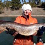
The high-country fishery of Show Low Lake offers a distinct atmospheric shift from the arid desert lowlands of Arizona. Nestled within the White Mountains, this location is defined by its elevation and the dense stands of ponderosa pine that line the water’s edge. For the serious angler, the appeal here goes beyond the catch; it is the technical challenge of fishing a 150-acre body of water where the shoreline topography creates complex shadow lines and wind tunnels. The air here is thinner and cooler, requiring an adjustment in both engine tuning for carbureted outboards and personal stamina for long days on the water.

The environment is characterized by a rugged mix of volcanic rock and pine forest, creating a backdrop that is as unforgiving as it is beautiful. Unlike the manicured urban reservoirs found near Phoenix, the shoreline here presents a mix of red dirt and rocky outcroppings. The presence of wildlife islands adds structure to the water, creating natural ambush points for predatory fish. Anglers visiting this region are typically targeting cool-water game fish that thrive in these oxygen-rich depths, making it a staple destination for those looking to escape the summer heat while maintaining access to a productive fishery.

Logistically, the area serves as a bridge between the remote wilderness and developed recreation. While the lake itself offers the solitude of the pines, the proximity to the city of Show Low ensures that vital resources are never too far out of reach. However, the seasoned captain knows that "close" doesn't always mean "convenient." Navigating the local infrastructure requires an understanding of seasonal traffic flows, specific gate times, and the nuances of high-altitude boating. This guide breaks down the essential access points and facilities required to execute a successful campaign on these waters.

Access & Getting There

Reaching Show Low Lake typically involves navigating US 60 or Highway 260, two major arteries that cut through the precipitous terrain of the Mogollon Rim. For anglers towing heavy glass boats or fifth wheels, these routes demand respect. The grades can be steep, and during the summer months, the two-lane sections often become bottlenecks due to heavy recreational traffic. Plan your ascent for early morning or late evening to avoid the midday congestion that plagues the switchbacks. The transition from highway speeds to the lake access roads requires vigilance, as elk and deer are frequent hazards along the tarmac, particularly during the dawn and dusk hours favored by fishermen.

Upon arrival, the primary access dynamic shifts to the boat launch and parking realities. The data indicates multiple access points, including shore entries suitable for families and dedicated boat ramps. The ramps in this region are generally serviceable, but water levels fluctuate. A ramp that offers easy launching in May might leave your trailer tires spinning on slick algae or dropping off the concrete end by late August. It is imperative to inspect the waterline before committing your rig, especially if you are launching solo. The local soil, a heavy clay-mix in spots, can become treacherous on the unpaved shoulders after a monsoon rain, so keeping your tow vehicle on the established gravel or pavement is non-negotiable.

πŸ’‘ Captain's Tip: High Altitude Performance

You are launching at significant elevation. Naturally aspirated tow vehicles will lose power on the steep grades approaching Show Low. Ensure your transmission cooler is functioning perfectly before hauling a heavy bass boat up the rim. Additionally, check your trailer tire pressure; the temperature swing from the desert floor to the mountain air can alter PSI significantly.

Parking is a critical logistical component here. The Show Low Auto Boat RV Storage, located approximately 1.4 miles from the water, offers a strategic contingency for those staying in the area for extended periods but lacking driveway space at their rental. For day trips, the immediate lot at the launch can fill rapidly. The Home Depot Parking Lot is roughly 4 miles away, and while not a primary staging area, knowing its location is useful for emergency trailer repairs or hardware runs. Note that Rainbow Lake Parking is over 7 miles away, making it an impractical overflow option for this specific water body. Stick to the designated launch parking or arrive well before sunrise to secure a spot for your trailer.

Weather plays a dominant role in access. The White Mountains are notorious for afternoon thunderstorms during the monsoon season (July through September). These storms build rapidly over the rim, transforming calm waters into a chop that can swamp low-freeboard bass boats. When the lightning flags go up, the boat ramp becomes a chaotic choke point. Smart crews monitor the western horizon and pull the plug on the day before the squall line hits the water. If you are shore fishing, the clay banks become incredibly slick when wet; sturdy hiking boots with aggressive tread are recommended over standard deck shoes.

Show Low Lake Pre-Trip Checklist

Facilities & Amenities

The infrastructure surrounding Show Low Lake is anchored heavily by the nearby Fool Hollow Lake Recreation Area. Located just over 2 miles away, this facility acts as the primary logistical hub for the region. It offers a level of developmentβ€”paved loops, designated camping, and sanitationβ€”that is superior to primitive access points. For the traveling angler, this means that while you may fish Show Low Lake, your base of operations and best source for immediate on-water amenities will likely be the Fool Hollow complex. The campground there features sites winding among the pines, providing windbreaks and shade that are essential for preserving ice and energy during multi-day trips.

When it comes to bait and tackle, the local options require careful timing. The Lucky Minnow in Pinetop-Lakeside is a highly-rated resource, but with an opening time of 10:00 AM on most days, it is useless for the dawn patrol angler. Similarly, the Silver Creek General Store, located roughly 7 miles away, also follows a 10:00 AM opening schedule. This is a critical piece of "negative knowledge": do not rely on buying live bait or replacement hooks on your way to the ramp in the morning. You must procure your consumables the evening before. The Fool Hollow Lake Recreation Area visitor contact station opens earlier, at 7:00 AM, making it the only viable morning option for last-minute permits or basic information, though its tackle selection will be limited compared to dedicated outfitters.

πŸ’‘ Captain's Tip: The 10:00 AM Rule

Local bait shops like The Lucky Minnow and Silver Creek General Store do not open until 10:00 AM. If you plan to hit the water at first light, you must purchase your nightcrawlers, minnows, or terminal tackle the day before. Rolling into town at 5:00 AM expecting to find an open bait shop will result in a delayed launch.

For lodging, the area offers a mix of developed campgrounds and RV parks. The Cinnamon Teal Loop Campground is a top-tier option within the nearby recreation area, offering immediate proximity to the water. For those requiring full hookups or mobile home amenities, the Holiday Forest Mobile Home Park and Pine Flat RV Park in Pinetop (approx. 10 miles away) provide reliable alternatives. These facilities are accustomed to boaters, but space for maneuvering large center consoles can be tight in the older parks. Always call ahead to confirm trailer parking availability. The Heritage Inn Snowflake offers a hotel option but is a significant drive (18 miles) from the launch, making it less ideal for those prioritizing time on the water.

The table below details the key facility metrics for planning your logistics:

Facility NameTypeDistanceKey Notes
Fool Hollow Lake Rec AreaHub / Bait / Camp2.6 milesOpens 7:00 AM. Primary facility hub.
Show Low Auto Boat RV StorageParking1.4 milesSecure storage for trailers.
The Lucky MinnowBait & Tackle10.3 milesOpens 10:00 AM. Plan accordingly.
Summit Medical CenterHospital3.5 milesNearest emergency medical care.
Truck Parking ClubParking5.5 milesOpen 24 Hours. Good for large rigs.

It is important to note a specific gap in services: there is no dedicated fuel dock on the water at Show Low Lake. All vessels must be fueled on the trailer at gas stations in town before launching. The nearest reliable fuel is along the Deuce of Clubs roadway. Additionally, while there are restrooms at the major access points (distances ranging from 1000 feet to 1.7 miles), fish cleaning stations are not explicitly confirmed at every ramp. Anglers should be prepared to transport their catch on ice and clean it at their campsite or residence to comply with waste disposal regulations.

Permits, Regulations & Fees

Fishing activities in this region fall under the jurisdiction of the state wildlife agency, and standard state fishing licenses are required for all anglers. The regulations here are strictly enforced to maintain the quality of the high-country fishery. Because Show Low Lake and its neighbor Fool Hollow are heavily utilized resources, rangers patrol frequently. Electronic licenses are generally accepted, but carrying a physical printout in your dry bag is a prudent backup in areas where cell service can be spotty due to the pine density and terrain.

Fool Hollow Lake Recreation Area operates as a fee area. If you are launching or accessing the water through this specific zone, a day-use fee is mandatory. These fees contribute directly to the maintenance of the ramps, the cleanliness of the "wildlife islands," and the stocking programs. The automated fee machines (if present) can be temperamental with credit cards; carrying small denominations of cash is a professional habit that saves time at the gate. There are no indications of a complex permit lottery for general access, but camping reservations for the Cinnamon Teal Loop or Upper Log Campground should be made weeks in advance during the summer season.

Cultural and environmental respect is paramount. The White Mountains hold significance for local tribes and residents. While the lake is public, many surrounding lands may be private or tribal property. "Kapu" or restricted areas are not explicitly marked on every corner, so the rule of thumb is simple: if it is fenced or posted, stay out. Furthermore, the introduction of aquatic invasive species is a major threat. Watercraft inspections may occur, and you are legally obligated to "Clean, Drain, and Dry" your vessel before transporting it between bodies of water. This is particularly critical if you have recently fished in waters known to harbor quagga mussels.

Events & Seasonal Information

The rhythm of Show Low Lake is dictated by the seasons of the high country. The fishing calendar is bifurcated by the winter freeze and the summer rush. In the spring, as the ice recedes (or the water warms, depending on the severity of the winter), the trout bite becomes aggressive near the surface. This is the time for light tackle and trolling tactics. As summer sets in, the water stratifies, and fish move deeper to find comfortable thermoclines. The recreational boat traffic also peaks from Memorial Day to Labor Day, turning the surface into a washing machine of wakes by noon. Serious anglers adjust by fishing "dawn patrol" (5:00 AM to 9:00 AM) or shifting to night fishing operations.

The "monsoon season" in late summer introduces a daily hazard. Clouds typically build by 11:00 AM, with violent thunderstorms releasing between 1:00 PM and 4:00 PM. These storms bring lightning, hail, and sudden temperature drops. The savvy captain plans their day to be off the exposed water or tucked into a protected cove by lunchtime. Conversely, the post-storm period in the late afternoon can produce glass-calm water and an intense feeding window as barometric pressure stabilizes.

πŸ’‘ Captain's Tip: The Afternoon Winds

Even without storms, the afternoon winds in the White Mountains can be relentless. The fetch across the lake can generate a tight, steep chop that is difficult for kayaks and small aluminum boats. Plan your drift to utilize the wind, but ensure your trolling motor batteries are fully charged to fight the headwind on the return trip.

Contact Information & Resources

For official inquiries regarding water levels, ramp conditions, and camping availability, the primary point of contact is the managing agency for the Fool Hollow Lake Recreation Area. They can be reached at (928) 537-3680. This line is your lifeline for real-time intelligence on whether the ramps are open or if fire restrictions are in place that might affect your shore lunch plans.

In the event of an emergency, the Summit Medical Center is located roughly 3.5 miles from the water. For on-water emergencies, cell signal is generally available but can be weak in the coves; a VHF radio is recommended for boaters. Always file a float plan with someone on shore, even if you are just going out for a few hours. The cold water temperatures, even in summer, present a hypothermia risk if you capsize. Self-reliance is the rule of the high country.

For precise locations of the boat ramps, real-time weather radar, and detailed bathymetry of the fishing grounds, consult the live dashboard and interactive maps below.

🎣

Show Low Lake

Show Low β€’ Arizona β€’ 34.2542, -110.0298
πŸ…ΏοΈ

Parking

5
Show Low Auto Boat RV Storage
⭐ 4.6 1.4 mi
πŸ“ 3301 E Deuce of Clubs, Show Low, AZ 85901, USA
πŸ•’
Monday: 8:00β€―AM – 5:00β€―PM
Tuesday: 8:00β€―AM – 5:00β€―PM
Wednesday: 8:00β€―AM – 5:00β€―PM
Thursday: 8:00β€―AM – 5:00β€―PM
Friday: 8:00β€―AM – 5:00β€―PM
Saturday: Closed
Sunday: Closed
πŸš— Get Directions
Rainbow Lake Parking
⭐ 4.6 7.1 mi
πŸ“ Rainbow Lake Dr, Lakeside, AZ 85929, USA
πŸš— Get Directions
The Home Depot Parking Lot
⭐ 1.5 4.0 mi
πŸ“ 5601 S White Mountain Rd, Show Low, AZ 85901, USA
πŸš— Get Directions
Truck Parking Club
5.5 mi
πŸ“ 6950 AZ-260, Show Low, AZ 85901, USA
πŸ•’
Monday: Open 24 hours
Tuesday: Open 24 hours
Wednesday: Open 24 hours
Thursday: Open 24 hours
Friday: Open 24 hours
Saturday: Open 24 hours
Sunday: Open 24 hours
πŸš— Get Directions
🐟

Bait & Tackle

3
The Lucky Minnow
⭐ 5.0 10.3 mi
πŸ“ 1488 E White Mountain Blvd suite A, Pinetop-Lakeside, AZ 85935, USA
πŸ•’
Monday: Closed
Tuesday: 10:00β€―AM – 6:00β€―PM
Wednesday: 10:00β€―AM – 6:00β€―PM
Thursday: 10:00β€―AM – 6:00β€―PM
Friday: 10:00β€―AM – 8:00β€―PM
Saturday: 10:00β€―AM – 8:00β€―PM
Sunday: 12:00 – 6:00β€―PM
πŸš— Get Directions
Silver Creek General Store
⭐ 4.6 7.1 mi
πŸ“ 8372 Silver Creek Dr, Show Low, AZ 85901, USA
πŸ•’
Monday: 10:00β€―AM – 6:00β€―PM
Tuesday: 10:00β€―AM – 6:00β€―PM
Wednesday: 10:00β€―AM – 6:00β€―PM
Thursday: 10:00β€―AM – 6:00β€―PM
Friday: 10:00β€―AM – 6:00β€―PM
Saturday: 10:00β€―AM – 6:00β€―PM
Sunday: 10:00β€―AM – 6:00β€―PM
πŸš— Get Directions
Fool Hollow Lake Recreation Area
⭐ 4.6 2.6 mi
πŸ“ 1500 Fools Hollow Rd, Show Low, AZ 85901, USA
πŸ•’
Monday: 7:00β€―AM – 8:30β€―PM
Tuesday: 7:00β€―AM – 8:30β€―PM
Wednesday: 7:00β€―AM – 8:30β€―PM
Thursday: 7:00β€―AM – 8:30β€―PM
Friday: 7:00β€―AM – 8:30β€―PM
Saturday: 7:00β€―AM – 8:30β€―PM
Sunday: 7:00β€―AM – 8:30β€―PM
πŸš— Get Directions
🏠

Lodging

5
Heritage Inn Snowflake
⭐ 4.8 18.0 mi
πŸ“ 161 Main St, Snowflake, AZ 85937, USA
πŸ•’
Monday: Open 24 hours
Tuesday: Open 24 hours
Wednesday: Open 24 hours
Thursday: Open 24 hours
Friday: Open 24 hours
Saturday: Open 24 hours
Sunday: Open 24 hours
πŸš— Get Directions
βš“

Boat Ramps

3
🚻

Restrooms

3
πŸ‘¨β€πŸ‘©β€πŸ‘§β€πŸ‘¦

Family Friendly

2
β™Ώ

Accessibility

β™Ώ

Wheelchair Access

Not Confirmed

πŸ•

Pets Allowed

Not Confirmed

⚠️ Some accessibility info not officially confirmed. Please verify with location directly.

πŸ“ Showing 21 facilities on map

πŸ“Š

About Our Fishing Reports & Forecasts

Our spot reports combine data-driven forecasts with curated local information. The forecast is generated by our proprietary Fishing Score algorithm (0–100%), which analyzes real-time data from Open-Meteo API, validated against NOAA CO-OPS tide gauges and USGS water-monitoring stations. The model weights tide dynamics (35%), wave energy (25%), wind patterns (20%) and time of day (20%)β€”factors shown to influence fish feeding behavior through marine-biology research and decades of charter log data.

Access, facilities and services information for each fishing spot is sourced from official datasets such as Recreation.gov (RIDB), state park & wildlife agencies, and geospatial providers like Google Maps. These sections undergo scheduled re-validation every 3–6 months to ensure that boat ramps, park access, contact details and local services remain accurate.

Narrative sections (catches, seasonal behavior, local tips) are synthesized from these data sources and refined following the Fishing Reports Today editorial guidelines, combining bibliographic research from ichthyology and oceanography with expert angler experience. Our team reviews reports on a regular basis, while the forecast model itself updates every 6 hours for real-time accuracy.

⚠️ Important: Always verify current local regulations, access restrictions and weather conditions before fishing. These reports are intended as a planning aid, not a guarantee of catches or safety. When in doubt, contact local authorities or park managers listed on the page.

Learn more about our methodology & data sources β†’

Leave a Reply

Your email address will not be published. Required fields are marked *