0%

Sandusky Bay Fishing Report Today 🎣

6 months ago · Updated 2 weeks ago

Sandusky Bay Spring Transition Fishing Report

Welcome to the late-winter to early-spring transition on Sandusky Bay. As the ice completely retreats and the thermal cycle of Lake Erie kicks into gear, we are seeing dynamic shifts in fish behavior. The water remains cold, and early spring winds can be unforgiving, but the pre-spawn staging is officially underway. Based on recent biological sampling and verified angler reports, the bay's ecosystem is waking up, offering dedicated anglers a chance at some of the heaviest fish of the year.

1. GO/NO-GO STATUS

  • Verdict: CAUTION - SHORE AND PROTECTED WATER FISHING RECOMMENDED
  • Ice Conditions: UNSAFE / OPEN WATER. Any residual ice from the winter transition is completely rotten or has blown out into the main lake. Do not attempt any hard-water access on the bay or connected harbors.
  • Weather & Water Impact: Air temperatures are hovering in the low to mid-40s. Sustained westerly winds have periodically pushed water out of the Western Basin, leading to lower-than-normal levels at concrete ramps and exposing dangerous drop-offs at the end of launch pads. Water clarity in the shallow western end is heavily stained to muddy due to intense wind churn.
  • Safety Advisory: Wear your USCG-approved PFD at all times. Shoreline rocks, breakwalls, and pier edges are slick with morning frost and wave spray. If you are launching a vessel, stick to the protected eastern pockets, marinas, or river mouths where the wind is broken by the landscape.

2. SPECIES INTEL

Recent biological ground truth data confirms several key species are actively feeding as they shake off the winter lethargy. Understanding what is moving right now is the key to a bent rod.

  • Primary Target - Channel Catfish: Verified catches are heavily concentrated around the Sheldon's Marsh coastal wetlands and the Huron Township shoreline. These whiskered bottom-feeders are moving into 13 to 15-foot holes near sunken timber to capitalize on dying or cold-stunned forage.
  • Active Target - Walleye: Massive pre-spawn females are currently staging. Verified activity near Curtice indicates fish are holding on deeper rock structures during daylight and pushing shallow under the cover of darkness to feed before the spawn.
  • Sleeper Pick - Eyetail Bowfin: Often overlooked by the walleye crowds, the ancient Bowfin is highly active right now. A recent verified catch along the Partnership Trail in Oak Harbor proves these apex predators are prowling the muddy, warming backwaters looking for an easy meal.
  • Baitfish Report: American Gizzard Shad (Sandusky area) and Spottail Shiners (Vermilion Rd area) are the dominant forage bases present right now. Matching these silver, deep-bodied profiles is critical. Cold-stunned shad are particularly vulnerable, making them the perfect bait profile.

3. TACTICAL STRATEGY

Channel Catfish (Sheldon's Marsh Area)

Where: Target the 10 to 14-foot drop-offs just outside the Sheldon's Marsh coastal wetlands. Look for submerged wood, channel swings, or transition zones from soft mud to a harder bottom composition.

From the editor

Tired of fishing with strangers you can’t trust?

Nautrek is the first social network for serious anglers — verified partners, real trips, cost splitting and intel sharing without burning your spots. Private beta now open.

Join the Waitlist — Free → 100+ anglers on the list
Nautrek App

Bait & Rigging: Carolina rig a 2-inch chunk of fresh cut American Gizzard Shad to match the local hatch perfectly. Use a 2/0 to 4/0 circle hook and a 1-ounce to 2-ounce no-roll sinker to keep the bait pinned securely to the bottom in the current.

Timing: Late afternoon to dusk. The sun warming the shallow mud flats throughout the day creates a slight temperature bump that washes into deeper water, triggering aggressive feeding windows.

Walleye (Western Basin & Curtice)

Where: Focus your efforts on the 15 to 20-foot rock transitions during the day, moving to 8 to 12-foot reef edges and pier structures (like the Jackson Street Pier in downtown Sandusky) at night.

Lures: During daylight, vertically jig 5/8oz hair jigs in purple/green or black/chartreuse. After dark, switch to a

shallow-diving stickbait or suspending jerkbait (like a Husky Jerk or Perfect 10) in chrome, silver/blue, or natural shad patterns to perfectly mimic the local Spottail Shiners and Gizzard Shad. Retrieve at a painfully slow pace with long pauses; cold water dictates a sluggish presentation.

Timing: The first two hours after sunset are prime time. The darkness gives these large, light-sensitive females the confidence to push up onto the shallow rock shelves to hunt.

Eyetail Bowfin (Oak Harbor / Partnership Trail)

Where: Target the shallow, muddy backwaters and tributary mouths around the Partnership Trail. Look for water depths of 2 to 5 feet where the dark mud bottom absorbs the sun's heat.

Bait & Rigging: Bowfin are opportunistic and aggressive. A heavy spinnerbait (1/2 oz) in white or chartreuse slowly rolled near the bottom works well. Alternatively, a dead-sticked chunk of cut bait or a large nightcrawler on a slip-sinker rig will draw out these ancient predators. Use a stout wire leader or heavy fluorocarbon (at least 20lb test), as their teeth will easily slice through standard monofilament.

Timing: Midday to late afternoon. Maximum solar radiation on the shallow mud flats is key to activating these fish.

4. WATER CLARITY & TEMPERATURE TRENDS

Expect heavily stained water in the western reaches of the bay and near the Portage River mouth due to recent wind churn. Visibility is currently limited to 6 to 12 inches in these areas. Towards the eastern basin and Huron, water clarity improves slightly to 1 to 3 feet. Surface temperatures are fluctuating between 38°F and 43°F. Remember, finding the warmest water, even if it's heavily stained, often yields the most active fish during this early transition period.

5. WEEKEND OUTLOOK & REGULATION REMINDER

With an incoming low-pressure system slated for the weekend, expect a slight warming trend followed by early spring rain. This barometric drop should trigger an aggressive pre-frontal bite across all staging species. Bank anglers should prepare for muddy shoreline conditions with proper waterproof footwear. Boat anglers must ensure their bilge pumps are fully operational and batteries are topped off, as fighting the cold winds will drain trolling motors quickly.

As a reminder, spring walleye limits and size restrictions are strictly enforced to protect the breeding stock. Brush up on the current ODNR regulations before heading out. Please handle the large pre-spawn females with extreme care, supporting their bellies horizontally if you plan to snap a quick photo before releasing them to complete their spawn.

Tight lines!

Editor's Choice: Must-Have Gear

FISHINGSIR Next-Gen Waterproof Chest Waders

★★★★★ 4.4 (7,370+ reviews)
  • 2-Ply Tech: Upgraded nylon with 2.5x higher density than standard fabrics.
  • 100% Waterproof: Lab-approved intrusion resistance with taped visible seams.
  • Ultra-Lightweight: Designed for all-day comfort while hunting or fishing.
Check Availability on Amazon

✓ Amazon's Choice | 100+ bought last month

🛒 Tactical Gear for this Spot

Bandit Walleye Deep

Mandatory for reaching deep schools in 35-50ft mud flats.

Check Price on Amazon #ad

As an Amazon Associate I earn from qualifying purchases. #ad

Loading forecast...

Live Fishing Conditions: Tides, Weather & Waves

Get real‑time tides, marine weather, swell and solunar activity for each spot so you know exactly when conditions line up for your best chance at a bite.

🎣

Sandusky Bay

Loading coordinates...

🌤️

WEATHER CONDITIONS

Weather
-- °F
--°C

Loading...

🌡️
Feels Like --°F --°C
💧
Humidity --%
💨
Wind -- mph -- km/h
🧭
Direction --
📊
Pressure -- inHg -- hPa
☀️
UV Index --
🌊

MARINE CONDITIONS

🌊 Wave Height
-- ft
-- m
Loading...
🧭 Wave Direction
--°
Loading...
⏱️ Wave Period
-- s
Loading...
📈 Tide Status
-- ft
-- m
Loading...
🌙

LUNAR & SOLUNAR

🌕

Loading...

Illumination: --%

Major Period --:-- - --:-- --:-- - --:--
Minor Period --:-- - --:-- --:-- - --:--
🌅 Sunrise --:--
🌇 Sunset --:--
📅

24-HOUR FORECAST

Loading fishing conditions...

Fishing Spots Map

🎣
Book a Fishing Charter near Sandusky Bay Fishing Report Today 🎣

Local guides & charters. Verified captains, instant booking, best price guaranteed.

See Available Trips →

My location
Loading map...

Local Access & Facilities

Sandusky Bay: The Gateway to Lake Erie’s Western Basin

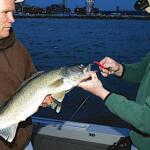
Sandusky Bay represents a unique intersection of maritime history, complex wetland ecosystems, and world-class fishery access. Situated on the southern edge of Lake Erie, this body of water serves as the transition zone between the remnants of the historic Great Black Swamp and the open expanse of the Great Lakes. For the serious angler, the bay offers more than just sheltered water; it is a strategic launchpad for targeting the renowned Western Basin walleye and perch populations. The topography here is defined by its shallow depth and rapid water exchange, creating a nutrient-rich environment that sustains a massive biomass of baitfish, which in turn attracts the heavy hitters of the sport fishing world.

The atmosphere around Bay View and the surrounding Sandusky area is a distinct blend of industrial grit and coastal vacation energy. Unlike the remote solitude of a mountain stream, fishing here puts you in the heart of a working waterfront shared by commercial freighters, high-speed island ferries, and a dedicated fleet of sport fishing vessels. The bottom composition varies from the muddy flats near the river mouths to the rocky structures closer to the islands, requiring captains to be versatile in their approach. Whether you are drifting the flats or making the run north to the reefs, understanding the local infrastructure is as critical as selecting the right lure.

While the walleye run is the headline event that draws thousands of trailers to these highways annually, the local ecosystem supports a diverse range of species. The presence of protected estuaries like Old Woman Creek and the vast wetlands of the Ottawa National Wildlife Refuge ensures a healthy recruitment of fish stocks. Anglers launching here are tapping into a biological engine that has been productive for centuries, dating back to the naval skirmishes of the War of 1812 that defined the region's political boundaries.

Access & Getting There

Navigating to Sandusky Bay requires a strategic approach to traffic, particularly during the peak summer months when the vacation crowds descend on the nearby amusement parks and islands. The primary artery for anglers trailering boats is State Route 2, which runs parallel to the lakeshore. If you are approaching from the east or west via the Ohio Turnpike (I-80/90), the key interchanges are US 250 (northbound) or State Route 53. Seasoned locals know that the stretch of Route 2 near the bay can become a bottleneck on Friday afternoons and Sunday evenings; plan your arrival for early morning or late evening to avoid the congestion that can add an hour to your transit time.

💡 Captain's Tip: Ferry Logistics

If your float plan involves launching from South Bass Island or Put-in-Bay, you must choose your ferry wisely. The Miller Boat Line (off SR 53) is your only option for transporting vehicles and boat trailers. The Jet Express is strictly for passengers. Arrive at the Miller dock at least 45 minutes early during the summer run, as commercial trucks and residents often have priority boarding.

The boat launch situation in this region is robust but demands patience. There are multiple access points scattered along the shoreline, including ramps near Bay View and closer to the city of Sandusky. The data indicates ramps situated at roughly 41.4967° N and 41.5350° N, providing direct access to the water. When launching directly into the bay, be mindful of the wind direction. The bay is shallow, and a strong northeast wind can stack water quickly, turning a simple launch into a treacherous retrieval. Conversely, strong southwest winds can blow water out of the bay, significantly reducing depth at the ramps. Always check the water level gauges before backing down a short ramp.

Parking for trucks and trailers is generally available but fills rapidly during the walleye run. The Jackson Street Parking Lot in Sandusky is a reliable option for those accessing the city-side waterfront, offering 24-hour access which is essential for night fishing excursions. For those heading to the islands without their boat, the Miller Ferry Parking Lot 5 provides ample space. Security in these lots is generally good, but standard precautions apply: lock your rod lockers and remove high-value electronics from the console if leaving the rig overnight.

Sandusky Bay Pre-Trip Checklist

Facilities & Amenities

The infrastructure surrounding Sandusky Bay is tailored to the needs of the Great Lakes angler, but services are spread out across several miles. Unlike a centralized marina complex where everything is on one dock, you may need to drive to different locations for bait, fuel, and ice. For immediate tackle needs, Hi Way Bait & Tackle is located approximately 4.2 miles from the central bay area. They open at 8:00 AM, which is suitable for the casual angler, but serious dawn patrol captains might need to secure bait the night before.

For those hitting the water before the sun comes up, Happy Hooker Outdoors (approx. 16.8 miles away in Oak Harbor) and Jeanett's Bait and Tackle (7.1 miles away in Port Clinton) are the logistical hubs. Notably, Happy Hooker opens at 6:00 AM, making it a critical stop for live bait and last-minute terminal tackle before launching for an early morning bite. If you are staging out of the islands, Lakeside Fishing Equipment offers support on the Marblehead peninsula side.

💡 Captain's Tip: Early Birds

Most local shops open between 6:00 AM and 8:00 AM. If you plan to launch at 4:30 AM to beat the crowd to the reef complex, you must buy your minnows or crawlers the evening prior. Aerated bait buckets are mandatory equipment here.

The charter fleet in this region is legendary. Operations like Eyehooker Lake Erie Fishing Charters and Reef Stalker Sport Fishing Charters set the standard for the area. These captains specialize in open-water trolling and drifting techniques specific to the Western Basin. If you are new to the area, booking a trip with a local guide like Seeing Red Charters can drastically shorten your learning curve regarding the seasonal movements of fish schools.

Regarding accommodation, anglers looking for proximity to the water have several solid options. Farrell House Lodge offers a high-rated stay just over 4 miles from the main access points. For a more traditional fish-camp atmosphere, Kotts Camp and Summer Breeze Association provide lodging that understands the needs of boaters—namely, space to park a rig and early morning departures. Note that while there are amenities on the mainland, services on the water (fuel docks) can be spaced far apart. Always leave the dock with a full tank; the run from the bay to the Canadian line is longer than it looks on a chart.

Permits, Regulations & Fees

Fishing the Sandusky Bay and Lake Erie complex requires strict adherence to state and federal regulations. The area is managed by the Ohio Department of Natural Resources (ODNR) Division of Wildlife. A valid Ohio fishing license is mandatory for anyone 16 years of age or older. Because this is a border water, it is absolutely critical to know exactly where the International Boundary Line sits in the lake. Crossing into Canadian waters without the proper remote border crossing permit (CANPASS) and Ontario fishing license can result in severe fines and vessel confiscation. Modern GPS units usually mark this clearly, but visual landmarks are non-existent on the open water.

Conservation is a major theme in this region. The Ottawa National Wildlife Refuge and the Old Woman Creek National Estuarine Research Reserve are federally protected areas nearby. While fishing is often a permitted activity in specific zones, these areas are primarily managed for migratory birds and wetland research. Access to these refuges is strictly controlled; for instance, the Ottawa Refuge entrance is located on the north side of State Route 2. Respect all "No Wake" zones and restricted entry signs, particularly in the marshlands where nesting birds are present.

Cultural respect is also paramount. The Perry's Victory & International Peace Memorial is a National Park Service site commemorating those who fought and died in the Battle of Lake Erie. While the waters surrounding the memorial are popular for boating, the site itself is a place of honor and international peace between the U.S., Canada, and Great Britain. When boating near Put-in-Bay, maintain a respectful distance from the seawalls of the memorial and adhere to all harbor rules regarding noise and speed.

Events & Seasonal Information

The fishing calendar in Sandusky Bay is dictated by the thermal cycle of Lake Erie. The season typically kicks off with the spring walleye run, often occurring right after ice-out. This is when the bay and the nearby reefs are most congested. As the water warms, the fish move deeper and further east, shifting the fleet's focus to open-water trolling during the summer months. The fall brings a resurgence of perch fishing, a beloved tradition where "filling the cooler" with yellow perch becomes the primary goal.

💡 Captain's Tip: Wind Awareness

Lake Erie is the shallowest of the Great Lakes and notoriously volatile. A 15-knot wind here creates steep, tight waves that are far more dangerous than similar winds on the ocean. If the forecast calls for winds over 15 knots from the Northeast, the bay entrance becomes a washing machine. Stay in the protected harbors.

Historically, the region comes alive in September to commemorate the Battle of Lake Erie (September 10th). This period often coincides with excellent late-summer fishing, but the boat traffic around Put-in-Bay can be intense due to historical reenactments and increased tourism. Anglers should plan for delays at fuel docks and ramps during this commemorative window.

Weather patterns here are distinct: mornings often start calm, with trade-wind style breezes picking up by 10:00 AM. In the summer, afternoon thunderstorms are common and move incredibly fast across the water. The shallow nature of the bay means water temperature can fluctuate rapidly; a few days of strong sun can spike temps and push fish to deeper, cooler water faster than expected.

Contact Information & Resources

For the most current information on lake conditions and regulations, anglers should consult the managing agencies directly. The Perry's Victory & International Peace Memorial can be reached at (419) 285-2184 for information regarding harbor access near the monument. For questions regarding the wetland areas, contact the Ottawa National Wildlife Refuge at 419-898-0014 or the Old Woman Creek Reserve at 419-433-4601.

Safety on the water is the responsibility of the captain. Ensure your VHF radio is functional and tuned to Channel 16 for emergencies. Cell reception is generally good across the bay and near the islands, but can be spotty on the open lake near the border. There is no substitute for self-reliance; carry flares, a backup propulsion method, and adequate life jackets for all souls on board.

For precise locations of boat ramps, real-time wind conditions, and directions to the nearest tackle shops, consult the live dashboard and interactive maps below.

🎣

Sandusky Bay

Bay View • Ohio • 41.4789, -82.8413
🅿️

Parking

5
Free Parking
⭐ 5.0 6.8 mi
📍 Sandusky, OH 44870, USA
🕒
Monday: Open 24 hours
Tuesday: Open 24 hours
Wednesday: Open 24 hours
Thursday: Open 24 hours
Friday: Open 24 hours
Saturday: Open 24 hours
Sunday: Open 24 hours
🚗 Get Directions
Parking lot
⭐ 5.0 6.9 mi
📍 202 W Market St, Sandusky, OH 44870, USA
🚗 Get Directions
Miller Ferry Parking Lot 5
⭐ 5.0 7.2 mi
📍 5309 Township Hwy 1059, Port Clinton, OH 43452, USA
🚗 Get Directions
Jackson Street Parking Lot
⭐ 4.8 6.8 mi
📍 134 Jackson St, Sandusky, OH 44870, USA
🕒
Monday: Open 24 hours
Tuesday: Open 24 hours
Wednesday: Open 24 hours
Thursday: Open 24 hours
Friday: Open 24 hours
Saturday: Open 24 hours
Sunday: Open 24 hours
🚗 Get Directions
🐟

Bait & Tackle

5
Lakeside Fishing Equipment
⭐ 5.0 6.5 mi
📍 Lakeside, OH 43440, USA
🕒
Monday: 7:00 AM – 9:00 PM
Tuesday: Closed
Wednesday: 7:00 AM – 9:00 PM
Thursday: Closed
Friday: 7:00 AM – 9:00 PM
Saturday: 7:00 AM – 9:00 PM
Sunday: Closed
🚗 Get Directions
Jeanett's Bait and Tackle
⭐ 4.9 7.1 mi
📍 4849 E Weyhe Rd, Port Clinton, OH 43452, USA
🕒
Monday: 6:00 AM – 7:00 PM
Tuesday: 6:00 AM – 7:00 PM
Wednesday: 6:00 AM – 7:00 PM
Thursday: 6:00 AM – 7:00 PM
Friday: 6:00 AM – 7:00 PM
Saturday: 6:00 AM – 7:00 PM
Sunday: 6:00 AM – 7:00 PM
🚗 Get Directions
Central Basin Bait, Tackle and Carryout
⭐ 4.8 15.8 mi
📍 910 Main St, Huron, OH 44839, USA
🕒
Monday: 8:00 AM – 7:00 PM
Tuesday: 8:00 AM – 7:00 PM
Wednesday: 8:00 AM – 7:00 PM
Thursday: 8:00 AM – 7:00 PM
Friday: 8:00 AM – 7:00 PM
Saturday: 8:00 AM – 7:00 PM
Sunday: 8:00 AM – 7:00 PM
🚗 Get Directions
Hi Way Bait & Tackle
⭐ 4.7 4.2 mi
📍 7006 E Harbor Rd, Lakeside Marblehead, OH 43440, USA
🕒
Monday: 8:00 AM – 4:00 PM
Tuesday: 8:00 AM – 4:00 PM
Wednesday: 8:00 AM – 4:00 PM
Thursday: 8:00 AM – 4:00 PM
Friday: 8:00 AM – 4:00 PM
Saturday: 8:00 AM – 4:00 PM
Sunday: 8:00 AM – 4:00 PM
🚗 Get Directions
Happy Hooker Outdoors
⭐ 4.7 16.8 mi
📍 9688 State Rte 2, Oak Harbor, OH 43449, USA
🕒
Monday: 6:00 AM – 6:00 PM
Tuesday: 6:00 AM – 6:00 PM
Wednesday: 6:00 AM – 6:00 PM
Thursday: 6:00 AM – 6:00 PM
Friday: 6:00 AM – 6:00 PM
Saturday: 6:00 AM – 6:00 PM
Sunday: 6:00 AM – 6:00 PM
🚗 Get Directions
🚤

Fishing Charters

4
Eyehooker Lake Erie Fishing Charters
⭐ 5.0 5.5 mi
📍 5925 Saylor St Dock 101, Lakeside Marblehead, OH 43440, USA
🕒
Monday: 6:00 AM – 10:00 PM
Tuesday: 6:00 AM – 10:00 PM
Wednesday: 6:00 AM – 10:00 PM
Thursday: 6:00 AM – 10:00 PM
Friday: 6:00 AM – 10:00 PM
Saturday: 6:00 AM – 10:00 PM
Sunday: 6:00 AM – 10:00 PM
🚗 Get Directions
Seeing Red Charters & lodging
⭐ 5.0 16.1 mi
📍 6395 N Russell Rd, Oak Harbor, OH 43449, USA
🕒
Monday: Open 24 hours
Tuesday: Open 24 hours
Wednesday: Open 24 hours
Thursday: Open 24 hours
Friday: Open 24 hours
Saturday: Open 24 hours
Sunday: Open 24 hours
🚗 Get Directions
JOB Fishing LLC - Lake Erie Fishing Charters
⭐ 5.0 5.2 mi
📍 2021 NE Catawba Rd, Port Clinton, OH 43452, USA
🕒
Monday: 5:30 AM – 8:30 PM
Tuesday: 5:30 AM – 8:30 PM
Wednesday: 5:30 AM – 8:30 PM
Thursday: 5:30 AM – 8:30 PM
Friday: 5:30 AM – 8:30 PM
Saturday: 5:30 AM – 5:30 PM
Sunday: 5:30 AM – 8:30 PM
🚗 Get Directions
Reef Stalker Sport Fishing Charters
⭐ 5.0 5.7 mi
📍 83 Madison St, Port Clinton, OH 43452, USA
🕒
Monday: Open 24 hours
Tuesday: Open 24 hours
Wednesday: Open 24 hours
Thursday: Open 24 hours
Friday: Open 24 hours
Saturday: Open 24 hours
Sunday: Open 24 hours
🚗 Get Directions
🏠

Lodging

5
Kotts Camp
⭐ 4.8 4.8 mi
📍 7931 E Harbor Rd, Lakeside Marblehead, OH 43440, USA
🚗 Get Directions
Portage River Paddling Company
⭐ 4.8 8.3 mi
📍 3134 W Harbor Rd, Port Clinton, OH 43452, USA
🕒
Monday: 10:00 AM – 9:00 PM
Tuesday: 10:00 AM – 9:00 PM
Wednesday: 10:00 AM – 9:00 PM
Thursday: 10:00 AM – 9:00 PM
Friday: 10:00 AM – 9:00 PM
Saturday: 10:00 AM – 9:00 PM
Sunday: 10:00 AM – 9:00 PM
🚗 Get Directions

Boat Ramps

3
🚻

Restrooms

3
👨‍👩‍👧‍👦

Family Friendly

2

Accessibility

Wheelchair Access

Not Confirmed

🐕

Pets Allowed

Not Confirmed

⚠️ Some accessibility info not officially confirmed. Please verify with location directly.

📍 Showing 27 facilities on map
🎣
Book a Fishing Charter near Sandusky Bay Fishing Report Today 🎣

Local guides & charters. Verified captains, instant booking, best price guaranteed.

See Available Trips →

📊

About Our Fishing Reports & Forecasts

Our spot reports combine data-driven forecasts with curated local information. The forecast is generated by our proprietary Fishing Score algorithm (0–100%), which analyzes real-time data from Open-Meteo API, validated against NOAA CO-OPS tide gauges and USGS water-monitoring stations. The model weights tide dynamics (35%), wave energy (25%), wind patterns (20%) and time of day (20%)—factors shown to influence fish feeding behavior through marine-biology research and decades of charter log data.

Access, facilities and services information for each fishing spot is sourced from official datasets such as Recreation.gov (RIDB), state park & wildlife agencies, and geospatial providers like Google Maps. These sections undergo scheduled re-validation every 3–6 months to ensure that boat ramps, park access, contact details and local services remain accurate.

Narrative sections (catches, seasonal behavior, local tips) are synthesized from these data sources and refined following the Fishing Reports Today editorial guidelines, combining bibliographic research from ichthyology and oceanography with expert angler experience. Our team reviews reports on a regular basis, while the forecast model itself updates every 6 hours for real-time accuracy.

⚠️ Important: Always verify current local regulations, access restrictions and weather conditions before fishing. These reports are intended as a planning aid, not a guarantee of catches or safety. When in doubt, contact local authorities or park managers listed on the page.

Learn more about our methodology & data sources

Leave a Reply

Your email address will not be published. Required fields are marked *