Catawba Island Fishing Report: Western Basin Post-Spawn Frenzy
The post-spawn transition is officially in full swing across the Western Basin of Lake Erie, and the action out of Catawba Island is nothing short of phenomenal. As water temperatures steadily climb into the upper 50s and low 60s, the lake's apex predators have shifted from their reproductive duties into an aggressive, ravenous feeding pattern. Thanks to several historic hatch classes over the past decade, the sheer biomass of fish currently swimming in these waters is staggering. Whether you are a seasoned tournament veteran or a weekend warrior looking to fill the freezer, the current conditions present some of the most reliable and exciting angling opportunities of the year.
GO/NO-GO STATUS
Verdict: GO - WITH CAUTION
The bite is absolutely world-class right now, making this a definitive "GO" for anyone looking to bend a rod. However, spring weather on Lake Erie is notoriously fickle and demands your utmost respect. The shallow nature of the Western Basin means that wave heights can stack up incredibly fast, particularly when winds oppose the natural lake current.
🎣Nautrek
Private Beta
J
M
R
100+ anglers on the waitlist
The fishing network where your reputation matters.
Find trusted captains, join real trips with cost splitting, and build your Angler Rank. Your spots stay private — you decide who sees your intel.
While southerly winds offer a protected lee near the Catawba mainland, any forecast calling for stiff North or Northeast winds should be treated with extreme caution, as the long fetch across the lake can turn the basin into a washing machine. Additionally, recent heavy spring rains have flushed a significant amount of debris from the tributary rivers into the open lake. Anglers must keep a sharp eye on the helm for floating logs and submerged hazards. Always monitor your VHF radio, keep a close eye on the offshore weather buoys, and never hesitate to pull lines if the horizon darkens.
SPECIES INTEL
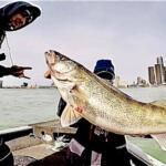
Primary Target: Walleye
Walleye are the undisputed kings of the Western Basin, and they are currently on a massive feeding binge. The bulk of the population has dispersed from the shallow spawning reefs and is now utilizing mid-depth transition zones to recuperate and hunt. Anglers are encountering massive schools of 2- to 6-year-old fish ranging from 15 to 24 inches, providing fast-paced limit catches. Furthermore, the presence of older, trophy-class fish from the legendary past hatches means that landing a 28-inch-plus heavy qualifier is a very realistic possibility on any given drop.
Sleeper Pick: Smallmouth Bass
While the armada of boats races offshore to troll for walleye, the nearshore island habitats are quietly exploding with world-class smallmouth bass action. The rocky shorelines, steep drop-offs, and limestone shoals surrounding the Bass Islands and Kelleys Island are currently holding massive, pre-spawn and spawning bronzebacks. These fish are highly aggressive and offer incredible pound-for-pound fights, making them an overlooked treasure for light-tackle enthusiasts who want a break from the trolling gear.
Baitfish Report
The primary forage base driving the current bite consists of gizzard shad and emerald shiners. Massive bait balls are being marked on sonar in the middle of the water column. Matching the slender profile and erratic swimming action of these baitfish is the most critical factor in your lure selection right now.
TACTICAL STRATEGY
Where to Find Them
The most productive water is currently located in the 20 to 35-foot depth band. Focus your efforts west of Catawba Island, working the transition waters near the Niagara Reef complex, the G Can area, and the open water stretches between the Bass Islands and Kelleys Island. If you are casting, look for the 24 to 30-foot depths where fish are staging near structural transitions and feeding on bait pushed by the current. Trollers should rely heavily on their electronics, searching for suspended hooks sitting just below the bait balls, typically 10 to 20 feet down in the water column.
Lure & Bait Selection
For Trollers: The transition from slow-speed crankbaits to faster spoon presentations is underway. Junior-sized spoons run in conjunction with jet divers or 2-ounce inline weights are pulling heavy limits. Deep-diving crankbaits remain highly effective when run 40 to 60 feet back behind planer boards, especially during low-light conditions.
For Casters: Drifting and casting is an Erie tradition that is producing excellent results. Utilize 1/2 to 3/4-ounce weapon-style spinner rigs and traditional weight-forward spinners. Hair jigs tipped with bait are also producing, though they require patience as you may have to sort through non-target species.
Color Patterns: Water clarity dictates your color choices. In areas with stained water from recent blows, rely on high-visibility, contrasting colors like firetiger, chartreuse, or pink/purple combinations. In clearer water, natural metallic finishes featuring gold, silver, or copper that accurately mimic emerald shiners will trigger more strikes.
Bait: Plump, lively nightcrawlers are absolutely mandatory for casting setups. Thread a fresh crawler onto your spinner harnesses, ensuring it trails straight to prevent line twist. When the bite gets finicky, pinching off the tail of the crawler to leave a shorter, scent-heavy profile can convert lookers into biters.
Timing the Bite
Early morning provides the most consistent and aggressive action. Getting to your waypoints before the sun gets high allows you to beat the heavy boat traffic that typically launches from the Catawba area ramps. However, the bite will remain steady throughout the afternoon as long as there is adequate cloud cover or a slight surface chop to break up the surface tension and reduce light penetration.
Pro Tip: When trolling spoons, speed is the ultimate trigger. Dial your GPS trolling speed to exactly 2.0 to 2.5 mph. If the bite suddenly slows, try sweeping your rod forward and quickly dropping it back. This creates a momentary flutter effect on the spoon, perfectly mimicking a dying baitfish and often triggering a reaction strike from trailing walleye.
Pro Tip: If you pivot to target smallmouth bass around the islands, remember that these fish are highly structure-oriented. Throw a 3.5-inch green pumpkin tube jig or a drop-shot rig paired with a goby-imitating plastic right against the steep rocky breaks in 10 to 15 feet of water. Keep your drag relatively loose, as these fish are notorious for hard, boat-side runs.
Pro Tip: Always pack a secondary, oversized cooler. The average grade of the walleye being caught right now is exceptional, and limits are being reached in just a few short hours. You do not want to run out of ice or storage space when the action is red hot.
REGULATIONS SNAPSHOT
Compliance with state wildlife regulations is strictly enforced on Lake Erie. Ensure all anglers have a valid fishing license and are familiar with the current seasonal rules.
Species
Daily Bag Limit
Minimum Size
Season Notes
Walleye
6 per angler
15 inches
Open year-round. Fish over 28 inches qualify for state trophy recognition.
Yellow Perch (West Zone)
30 per angler
None
West Zone includes waters from approximately Toledo to Huron.
Black Bass (Largemouth & Smallmouth)
1 per angler
18 inches
Spring regulations in effect (May 1 - late June) to protect spawning fish.
REGIONAL ALTERNATIVE
If a strong North or Northeast wind makes the open waters of the Western Basin unfishable, do not cancel your trip. Instead, trail your boat south and pivot to the protected waters of Sandusky Bay or the Sandusky River. The bay offers miles of sheltered shoreline and excellent, wind-protected fishing for channel catfish and largemouth bass. Launch near the Dempsey Access or the downtown Fremont access points.
The river systems are also a fantastic backup plan, as they hold aggressive white bass and resident walleye. Cast small inline spinners, 1/8-ounce white curly-tail grubs, or small shallow-diving crankbaits along current seams, bridge pilings, and shoreline riprap. This pivot keeps you fishing safely out of the dangerous swells while still providing constant, rod-bending action to salvage a blown-out day on the big lake.
Tight lines!
Editor's Choice: Must-Have Gear
FISHINGSIR Next-Gen Waterproof Chest Waders
★★★★★4.4 (7,370+ reviews)
2-Ply Tech: Upgraded nylon with 2.5x higher density than standard fabrics.
100% Waterproof: Lab-approved intrusion resistance with taped visible seams.
Ultra-Lightweight: Designed for all-day comfort while hunting or fishing.
As an Amazon Associate I earn from qualifying purchases. #ad
Loading forecast...
Live Fishing Conditions: Tides, Weather & Waves
Get real‑time tides, marine weather, swell and solunar activity for each spot so you know exactly when conditions line up for your best chance at a bite.
🎣
Catawba Island
Loading coordinates...
🌤️
WEATHER CONDITIONS
--°F
--°C
Loading...
🌡️
Feels Like--°F--°C
💧
Humidity--%
💨
Wind-- mph-- km/h
🧭
Direction--
📊
Pressure-- inHg-- hPa
☀️
UV Index--
🌊
MARINE CONDITIONS
🌊Wave Height
-- ft
-- m
Loading...
🧭Wave Direction
--°
Loading...
⏱️Wave Period
-- s
Loading...
📈Tide Status
-- ft
-- m
Loading...
🌙
LUNAR & SOLUNAR
🌕
Loading...
Illumination: --%
Major Period--:-- - --:----:-- - --:--
Minor Period--:-- - --:----:-- - --:--
🌅Sunrise--:--
🌇Sunset--:--
📅
24-HOUR FORECAST
Loading fishing conditions...
Fishing Spots Map
🎣
Book a Fishing Charter near Catawba Island Fishing Report Today 🎣
Local guides & charters. Verified captains, instant booking, best price guaranteed.
There was an error loading the map. Please try refreshing the page.
Info
Local Access & Facilities
Catawba Island sits at the heart of the Western Basin of Lake Erie, a location revered by seasoned anglers as one of the most productive freshwater fisheries in North America. While geographically a peninsula rather than a true island, this limestone jut offers immediate access to a complex ecosystem defined by glacial grooves, rocky shelves, and the historic Bass Islands. For the expert angler, Catawba is more than a scenic waypoint; it is the strategic launchpad for targeting trophy Walleye, Smallmouth Bass, and Yellow Perch in waters that demand respect and navigational precision.
The atmosphere here is a distinct blend of holiday bustle and serious maritime industry. Unlike the manicured, resort-heavy vibes of other lake destinations, Catawba retains a rugged, working-class edge driven by the ferry lines and the charter fleet. The water is often stained with the nutrient-rich sediment that fuels the food web, and the horizon is dominated by the limestone cliffs of the islands and the imposing Doric column of Perry's Victory & International Peace Memorial. This is big water fishing, where conditions can shift rapidly from a flat calm to a dangerous chop, requiring captains to be as attuned to the barometer as they are to their depth finders.
Primary targets here shift with the water temperature, but the reputation of the area is built on the Walleye migration. The structure surrounding the island, combined with the proximity to the reefs and the deeper waters toward the Canadian line, creates a perfect ambush point for predatory fish. Whether you are trolling deep divers off the limestone shelves or drifting soft craws for Smallmouth on the rocky humps, Catawba Island serves as the central hub for the entire Western Basin campaign.
Access & Getting There
Reaching Catawba Island requires navigating the bottleneck of the summer tourist season, primarily driven by the ferry traffic heading to Put-in-Bay and Middle Bass Island. The primary artery is State Route 53, which runs north from the Ohio Turnpike. Experienced captains know that during peak summer weekends, this two-lane road can become gridlocked with tourists and boat trailers. To avoid the congestion, early dawn arrivals are essential. If you are trailing a larger vessel, be hyper-aware of the ferry schedules for the Miller Boat Line, as traffic surges dramatically around their departure and arrival times.
For launching, the area offers a mix of private marina access and public facilities. While there are local ramps, many pros utilize the Public Launch located approximately 7.7 miles away in Port Clinton on West Lakeshore Drive. This facility is rated highly for its accessibility, though it places you a short run west of the Catawba tip. For those staying locally, navigating the marinas requires attention to depth charts, as water levels in the marina channels can fluctuate with the seiche effect common on Lake Erie.
💡 Captain's Tip: The Seiche Effect
Lake Erie is shallow and oriented southwest to northeast. Strong winds can push water from one end of the lake to the other, causing water levels at ramps to drop or rise significantly in hours. Always check the real-time water level data before committing to a shallow launch.
Weather plays a critical role in accessibility here. The Western Basin is notoriously shallow, meaning wind generates steep, tight waves very quickly. When the wind howls from the Northeast, the fetch across the lake piles water into the Catawba shoreline, making launch and recovery hazardous at exposed ramps. In these conditions, the leeward side of the peninsula or the protected harbors in Port Clinton offer the only safe refuge. Conversely, a Southwest wind tends to flatten the nearshore waters, providing a window for smaller craft to access the reef complexes.
Parking requires a tactical approach. The Miller Ferry Parking Lots dominate the northern tip of the peninsula. While these are primarily for ferry passengers, they indicate the volume of vehicle traffic in the area. Miller Ferry Parking Lot 3 and Lot 5 are within 1.5 miles of the tip, but for boat trailers, you must secure parking at your designated launch facility or marina. Do not assume roadside parking is available, as local ordinances are strictly enforced to manage the ferry queues.
Catawba Island Pre-Trip Checklist
Facilities & Amenities
The infrastructure on Catawba Island is purpose-built for the sportfishing industry. You will not find big-box marine stores on every corner; instead, the area relies on specialized, high-quality independent shops that understand the specific needs of the Lake Erie angler. Jeanett's Bait and Tackle, located just 1.2 miles from the main hub on East Weyhe Road, is a staple for the dawn patrol, opening at 6:00 AM daily. They are known for having the right crawler harnesses and fresh bait ready before the sun breaks the horizon.
For more extensive outfitting or bulk bait orders, N.A.S. Inc. (also known as Best Bait) is located about 5.6 miles away on East Bayshore Road. For those transiting from the west, Happy Hooker Outdoors in Oak Harbor (14.7 miles out) is a legendary stop for up-to-the-minute reports and specialized Walleye gear. Hi Way Bait & Tackle on East Harbor Road is another reliable option within a 3-mile radius, ensuring you are never far from resupply.
💡 Captain's Tip: Fuel Logistics
While there are fuel docks at the major marinas like Sunburst Harbor, lines can be long during the weekend rush. Pros trailer their boats to gas stations on SR 53 or SR 2 before launching to save time and money. Ensure your tanks are topped off before hitting the water, as fuel consumption increases significantly in the choppy Erie chop.
The charter fleet here is world-class. Operations like Champion Charters and Eyehooker Lake Erie Fishing Charters operate directly out of Lakeside Marblehead, less than a mile from the core fishing grounds. These are not casual tourist rides; they are heavy-hitting sportfishing operations equipped for big water. If you are looking to network or observe how the pros are rigging, a walk down the docks at Saylor Street in the late afternoon is an education in itself. You will see cleaning tables piled with Walleye and captains discussing the day's thermocline depth.
Regarding lodging, the culture leans heavily toward fish camps and seasonal mobile home parks rather than luxury hotels. West Harbor Lagoons Mobile Home Park and Kotts Camp offer proximity to the water, catering to anglers who are here to fish hard and sleep fast. For a more traditional stay, the Farrell House Lodge in Sandusky offers high-rated accommodation, though it requires a 9-mile commute to the launch. Sunburst Harbor Marina also provides amenities that bridge the gap between storage and accommodation.
Permits, Regulations & Fees
Fishing the waters around Catawba Island places you in a regulatory environment that requires vigilance. The area is managed by the State Fishing Agency (Ohio DNR), and officers are active on the water and at the ramps. A valid Ohio fishing license is mandatory for all anglers 16 and older. However, the proximity to the Canadian border—which runs through the middle of the lake just north of the islands—adds a layer of complexity. If you plan to cross the international line, you must adhere to Canadian regulations and reporting requirements. GPS plotters with clearly marked border lines are essential equipment here.
Conservation is a major theme in this ecosystem. West Sister Island National Wildlife Refuge, located approximately 18.3 miles northwest of Catawba, is a critical area for experienced captains to understand. Established by President Franklin D. Roosevelt in 1938, this 82-acre island is a federally designated wilderness area and a vital rookery for Herons and Egrets. Access to West Sister Island is strictly prohibited. You cannot land, dock, or walk on the island. It is for research only. Anglers may fish the waters surrounding it, but maintaining a respectful distance to avoid disturbing the nesting birds is not just etiquette; it is federal law.
Similarly, the Ottawa National Wildlife Refuge on the mainland (19.4 miles west) protects the remaining Great Black Swamp habitat. While this area allows for specific recreational activities, it is primarily a sanctuary. When fishing near these protected zones, be mindful of "No Wake" zones and specific seasonal closures that may protect spawning grounds or migratory paths. The cultural respect for these waters runs deep; the Perry's Victory & International Peace Memorial stands as a reminder of the 1813 Battle of Lake Erie, a site of immense historical significance. Treat the waters around the monument and the islands with the respect due a historical battlefield.
Events & Seasonal Information
The fishing calendar at Catawba Island is dictated by the seasons of the lake. Spring brings the massive Walleye run, drawing thousands of anglers to the reefs north of Camp Perry and around the Bass Islands. This is the "trophy season," where the chance of landing a 10-pound fish is highest. As the water warms into summer, the fish move deeper and migrate east, changing the tactics from jigging to trolling with planer boards and dipsy divers.
Perry's Victory & International Peace Memorial is the center of cultural events, particularly around September 10th, the anniversary of the Battle of Lake Erie. During these commemorative events, boat traffic around Put-in-Bay (6.4 miles north) increases exponentially. Anglers should anticipate delays and crowded waterways during this period. The memorial's visitor center operates from mid-May through mid-October, coinciding perfectly with the prime boating season.
💡 Captain's Tip: The Mayfly Hatch
In early summer, the hexagenia limbata (Mayfly) hatch can be massive, coating boats and slicking decks. While a nuisance to humans, it signals a feeding frenzy for fish. However, with so much natural bait in the water, the bite can sometimes slow down. Downsizing lures and matching the hatch becomes the strategy of the day.
Winter does not shut down the fishery; it merely changes the platform. When the Western Basin freezes solid, an "ice city" emerges off Catawba, with airboats and shanties targeting Walleye and Perch through the hard water. However, the ice on Lake Erie is dynamic and dangerous due to currents and wind. Local knowledge is vital for safe ice access.
Contact Information & Resources
For official information regarding the monuments and protected areas, the National Park Service manages Perry's Victory and can be reached at (419) 285-2184. For questions regarding the wildlife refuges, contact the Ottawa National Wildlife Refuge or the West Sister Island management office at 419-898-0014. These agencies are your primary source for current access rules and environmental alerts.
Safety on Lake Erie is the responsibility of the captain. The U.S. Coast Guard maintains a heavy presence in the sector, and monitoring VHF Channel 16 is mandatory for situational awareness. In the event of an emergency, response times can vary based on sea state, so self-reliance is key. Ensure all safety gear exceeds the minimum Coast Guard requirements, particularly regarding cold water survival suits during the shoulder seasons.
For precise locations of the boat ramps, bait shops, and real-time wind conditions, consult the live dashboard and interactive maps below.
🎣
Catawba Island
Port Clinton • Ohio • 41.5642, -82.8396
🅿️
Parking
5
Miller Ferry Parking Lot 5
⭐ 5.01.3 mi
📍5309 Township Hwy 1059, Port Clinton, OH 43452, USA
Our spot reports combine data-driven forecasts with curated local information. The forecast is generated by our proprietary Fishing Score algorithm (0–100%), which analyzes real-time data from Open-Meteo API, validated against NOAA CO-OPS tide gauges and USGS water-monitoring stations. The model weights tide dynamics (35%), wave energy (25%), wind patterns (20%) and time of day (20%)—factors shown to influence fish feeding behavior through marine-biology research and decades of charter log data.
Access, facilities and services information for each fishing spot is sourced from official datasets such as Recreation.gov (RIDB), state park & wildlife agencies, and geospatial providers like Google Maps. These sections undergo scheduled re-validation every 3–6 months to ensure that boat ramps, park access, contact details and local services remain accurate.
Narrative sections (catches, seasonal behavior, local tips) are synthesized from these data sources and refined following the Fishing Reports Today editorial guidelines, combining bibliographic research from ichthyology and oceanography with expert angler experience. Our team reviews reports on a regular basis, while the forecast model itself updates every 6 hours for real-time accuracy.
⚠️ Important: Always verify current local regulations, access restrictions and weather conditions before fishing. These reports are intended as a planning aid, not a guarantee of catches or safety. When in doubt, contact local authorities or park managers listed on the page.
To provide the best experiences, we use technologies like cookies to store and/or access device information. Consenting to these technologies will allow us to process data such as browsing behavior or unique IDs on this site. Not consenting or withdrawing consent, may adversely affect certain features and functions.
Functional Always active
The technical storage or access is strictly necessary for the legitimate purpose of enabling the use of a specific service explicitly requested by the subscriber or user, or for the sole purpose of carrying out the transmission of a communication over an electronic communications network.
Preferences
The technical storage or access is necessary for the legitimate purpose of storing preferences that are not requested by the subscriber or user.
Statistics
The technical storage or access that is used exclusively for statistical purposes.The technical storage or access that is used exclusively for anonymous statistical purposes. Without a subpoena, voluntary compliance on the part of your Internet Service Provider, or additional records from a third party, information stored or retrieved for this purpose alone cannot usually be used to identify you.
Marketing & Affiliates
The technical storage or access is required to create user profiles to send advertising, or to track the user on a website or across several websites for similar marketing purposes, including affiliate tracking for products recommended in our reports.


Leave a Reply