


Niguana Arm Lake: The Gateway to Mille Lacs' Hidden Structure
Situated in Vineland, Minnesota, Niguana Arm Lake serves as a critical strategic entry point to the legendary waters of the Mille Lacs ecosystem. For the expert angler, this location is defined not just by the water column, but by the unique topography of the nearby Mille Lacs National Wildlife Refuge. This area presents a rugged, complex fishery characterized by jumbled rock, submerged boulders, and gravel bars that radiate from Hennepin and Spirit Islands. Unlike the manicured reservoirs found elsewhere in the state, this fishery demands respect for both its navigational hazards and its protected status.
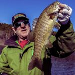
The atmosphere here is distinctly "Northwoods," where the red pine horizon meets the expansive, often turbulent blue water. It is a place where serious captains target the transition zones created by the refuge's unique geology. While the surface may seem calm in the lee of the islands, the underwater structure is a magnet for Minnesota's premier game fish. The presence of colonial nesting birds—including the American white pelican and the state-threatened common tern—signals a healthy baitfish population, making this arm a prime location for anglers looking to grind out trophy catches away from the community holes.
Seasoned pros understand that fishing Niguana Arm requires a dual focus: mastering the bottom structure and adhering to strict conservation boundaries. The nearby refuge, established in 1915, is the smallest in the National Wildlife Refuge System at merely 0.57 acres, yet its impact on the local fishing patterns is outsized. The interaction between the protected rocky outcrops and the open water currents creates feeding lanes that hold fish during shifting pressure systems. This is not a "drop a line and wait" location; it is a tactical arena for those who know how to read your electronics and respect the water.
💡 Captain's Tip: The 100-Yard Rule
The Mille Lacs National Wildlife Refuge islands are strictly off-limits. Federal regulations mandate a 100-yard buffer zone for all watercraft. Smart skippers use this perimeter to their advantage, drifting the legal edge where scared baitfish often get pushed by current and structure.
Access & Getting There
Reaching Niguana Arm Lake and the Vineland area requires navigating the rural arteries of central Minnesota. The primary access corridor is US-169, a route well-known to anglers towing heavy glass boats. During the peak summer season, traffic on 169 can bottle up near Onamia and Garrison, particularly on Friday afternoons and Sunday evenings. For those coming from the east or utilizing the refuge area specifically, State Highway 65 offers an alternative, though it is a two-lane highway where passing opportunities are limited. Plan your transit to avoid the mid-day congestion, aiming for an arrival well before sunrise to secure prime parking and launch positioning.
The launch reality in this sector of Minnesota is mixed. While the data indicates boat ramps are available within an 8 to 9-mile radius, anglers should be prepared for facilities that prioritize utility over luxury. The local ramps often feature concrete slabs that can become slick with algae during low water periods. It is imperative to check your trailer bearings and tires before the trip, as the access roads can be gravel or rough pavement. The proximity of heavy ATV usage, evidenced by the Red Top/Soo Line ATV Parking and Solana ATV Trail Parking, means that parking lots are often shared with off-road enthusiasts. This mixed-use dynamic can lead to crowded lots by 8:00 AM on weekends. Expert advice suggests launching at "gray light" to beat the rush.
Weather is the single biggest logistical factor when fishing this open water system. The fetch across Mille Lacs can build dangerous chop quickly when winds exceed 15 mph. Because the Niguana Arm area is exposed to specific wind directions, launching and retrieving can become hazardous. If the forecast calls for sustained winds, verify the orientation of your chosen ramp. A ramp that is perfectly calm at dawn can become a washing machine by noon if the wind shifts. Always have a backup launch plan on the leeward side of the lake if conditions deteriorate. The specific geography of the refuge islands offers little wind protection for boats, so rely on your vessel's seaworthiness rather than geographical shelter.
Parking strategy here goes beyond just finding a slot. With the heavy influence of the ATV community at lots like Red Top (12.1 miles away) and Solana (23 miles away), trailer maneuvering space can be tight. Security is generally good in these high-traffic outdoor recreation areas, but standard precautions apply: lock your trailer tongue and stow loose gear. If you are utilizing the shore access points near Vineland, ensure you are not blocking local easements or private driveways, as enforcement on parking infringements can be strict to maintain local access flow.
💡 Captain's Tip: Mixed-Use Traffic
The parking areas near Vineland often service both anglers and ATV riders. When backing your trailer, be hyper-aware of smaller off-road vehicles that may be zipping through the lot. Arrive before 6:00 AM to secure a pull-through spot before the ATV trailers arrive.
Niguana Arm Lake Pre-Trip Checklist
Facilities & Amenities
The infrastructure surrounding Niguana Arm is robust enough to support professional campaigns, provided you know where to look. Unlike urban harbors with comprehensive marinas at the water's edge, the amenities here are distributed across the nearby towns of Garrison, Aitkin, and Isle. For bait and tackle, Garrison Sports Bait and Tackle is the primary logistical hub, located approximately 10.1 miles from the spot. They open at 7:00 AM daily, which is sufficient for most, but true dawn patrol anglers may need to secure live bait the night before. Their rating of 4.7 suggests they maintain a high quality of minnows and leeches, essential for the live-bait rigging techniques popular in these waters.
For those requiring specialized gear or repairs, Bill's Sportsmans Service in Aitkin (20.7 miles away) offers an alternative, though their 8:00 AM opening time is less convenient for early risers. The charter fleet in this region is world-class, reflecting the difficulty and potential of the fishery. Operators like Voge Outdoors and Mille Lacs Lake Guiding (both rated 5 stars) are known for their heavy-hitter reputations. These aren't just boat drivers; they are structure specialists who understand the seasonal movements around the refuge islands. If you are new to the specific rock piles of this arm, hiring a guide from Windy Fishing Guide Service for a half-day reconnaissance trip can cut years off your learning curve.
It is critical to note what is missing to avoid ending your trip early. The immediate access points near Niguana Arm often lack fuel docks and sophisticated fish cleaning stations. You must fuel your vessel on the highway before launching. Similarly, ice is not always available at the ramp itself. Stock up on block ice at the gas stations in Garrison or Isle before you hit the final access road. The "rough" nature of the refuge area means self-sufficiency is key; do not expect a ship's store or a mechanic at the water's edge.
Lodging options cater to the rugged, outdoor-focused demographic. Wealthwood RV Resort and Wiggle Room RV Seasonal Campsites provide excellent bases of operation for anglers hauling campers. For those seeking a more immersive experience, the Black Bass Lake Backpacking Site offers a remote stay, though it requires hiking in gear, making it less suitable for boat anglers but perfect for shore casters seeking solitude. Deer Lake Farmstead offers a highly-rated, more comfortable alternative for those who prefer a roof over their heads after a long day on the water.
Key Local Facilities Table
| Facility Name | Type | Distance | Key Details |
|---|---|---|---|
| Garrison Sports Bait and Tackle | Bait & Tackle | 10.1 miles | Opens 7:00 AM. High rating (4.7). Critical for live bait. |
| Voge Outdoors | Charter | 9.8 miles | 5-star rating. Opens 6:00 AM. Expert local knowledge. |
| Wealthwood RV Resort | Lodging/RV | 9.0 miles | 5-star rating. Good for multi-day trips with boat trailers. |
| Red Top/Soo Line Parking | Parking | 12.1 miles | Mixed-use (ATV). No trailer specific amenities listed. |
| Mille Lacs Lake Guiding | Charter | 8.8 miles | 5-star rating. Specialized structure fishing. |
Permits, Regulations & Fees
Navigating the regulatory landscape of Niguana Arm is as important as navigating the physical water. The most critical regulation involves the Mille Lacs National Wildlife Refuge. This federally protected area, comprising Spirit and Hennepin Islands, is strictly CLOSED to public access. This is not merely a suggestion; it is a federal mandate designed to protect sensitive breeding colonies of ring-billed gulls, herring gulls, cormorants, and pelicans. Anglers must maintain a minimum distance of 100 yards offshore while fishing or observing wildlife. Violating this buffer zone not only disturbs the wildlife but carries significant federal fines.
The "Why" behind these strict rules lies in the fragility of the ecosystem. These rock islands are among the few nesting sites for the state-threatened common tern. The presence of boats within the buffer zone can flush nesting birds, leaving eggs and chicks vulnerable to exposure and predation. As an angler, respecting this "Kapu" (forbidden) zone is essential for the long-term health of the fishery. The birds are your allies in locating baitfish; protecting their habitat ensures the bait—and the game fish—remain in the area.
General fishing activities are managed by the State Fishing Agency (MN DNR). Anglers should be acutely aware of the specific slot limits and harvest regulations for Mille Lacs Lake, which are notoriously dynamic and subject to change based on annual assessments. Always consult the latest official state sources and local signage at the boat ramp before keeping any fish. There is no indication of a specific permit required to launch at the unnamed ramps, but a valid Minnesota fishing license is mandatory. Additionally, be mindful of tribal treaty rights and management co-management in this region, which adds a layer of cultural and legal significance to the resource.
💡 Captain's Tip: Slot Limit Vigilance
Regulations on this body of water can change mid-season. Do not rely on last year's rulebook. Check the MN DNR app or the board at Garrison Sports the morning of your trip to ensure you are legal regarding size and bag limits.
Events & Seasonal Information
The rhythm of Niguana Arm is dictated by the seasons of the North. The open water season is the primary draw, with the "bite" often correlating with the nesting cycles of the birds on the refuge islands. Early summer brings a flurry of activity as baitfish move shallow to spawn, drawing predators into the rocky structures surrounding the refuge. This is often considered the peak time for action, though it brings the heaviest boat traffic.
Tournament fishing is a staple of the wider Mille Lacs culture. While specific event dates fluctuate, the summer months are typically packed with competitive circuits targeting Walleye and Bass. If you prefer solitude, avoid weekends when major state tournaments are scheduled, as the pressure on the known spots near the islands increases ten-fold. Conversely, the "shoulder seasons" of late fall offer some of the best trophy potential for those willing to brave the cold and wind, with fewer boats competing for the prime drifts.
Timing your day is crucial. The wind machine often turns on by 10:00 AM. The most productive window is frequently the "dawn patrol" hours from first light until the breeze stiffens. During high summer, a secondary window often opens in the evening as the winds lay down, offering a few hours of prime fishing before dark. Note that the charter fleets, such as Voge Outdoors, start their days at 6:00 AM, confirming that the early bird truly gets the worm in this fishery.
Contact Information & Resources
For official inquiries regarding the refuge and restricted areas, contact the Mille Lacs National Wildlife Refuge directly. They are managed via the Rice Lake National Wildlife Refuge office.
Phone: 218-768-2402
Email: ricelake@fws.gov
Address: C/O Rice Lake National Wildlife Refuge, 36289 State Highway 65, McGregor, MN 55760
For safety, always file a float plan with a reliable contact on land. Cell service can be spotty in the troughs of the waves or near the islands. In the event of an emergency, dial 911, but be aware that response times on the water can be lengthy. Self-reliance is your primary safety net. Carry a marine radio, adequate life jackets, and a spare prop.
For precise locations of the boat ramps, real-time wind conditions, and detailed bathymetry of the structure surrounding the refuge islands, consult the live dashboard and interactive maps below.


Leave a Reply