


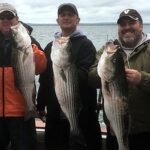
Magnolia Springs represents a sophisticated, brackish-water playground that serves as a quiet tactical base for anglers targeting the rich estuarine systems of Lower Alabama. Unlike the high-traffic, neon-lit marinas of the main Gulf coast, this fishery is defined by its serene river systems—specifically the Magnolia and Fish Rivers—which empty into the expansive Weeks Bay and eventually Mobile Bay. For the expert angler, this location offers a unique strategic advantage: shelter from the heavy Gulf swells while maintaining striking distance to trophy inshore species like Speckled Trout, Redfish, and Flounder that patrol the grassy banks and dock pilings of the river mouths.
The atmosphere here is distinctly different from the open ocean chase. It is a fishery of patience and precision, characterized by tannic waters, overhanging oaks, and a historic Southern river culture. While the adrenaline of the pelagic chase awaits just south in the Gulf, Magnolia Springs serves as the sanctuary for the technical skiff captain and the kayak specialist. The proximity to Weeks Bay National Estuarine Research Reserve ensures that the water quality and habitat remain pristine, providing a nursery for baitfish that drives the local food chain. This is not a place for "run and gun" heavy throttle tactics; it is a place for reading the tides and working the edges of the marsh.
Seasoned captains appreciate this area for its versatility. When the winds howl out of the south, rendering the Gulf impassable, the protected waters of the Fish River and Weeks Bay offer fishable, productive alternatives. Conversely, on calm days, the run out to the Mobile Bay rigs or the pass is manageable for bay boats. The primary draw here is the year-round consistency of the inshore bite, augmented by the seasonal pulses of migratory species that push into the estuaries during the spring and fall transitions.
Access & Getting There
Navigating to Magnolia Springs requires a shift in mindset from the interstate-heavy travel of typical coastal destinations. The primary artery is U.S. Highway 98, a route that can see significant congestion during peak summer months and festival weekends. For anglers towing skiffs or bay boats, the approach is generally smooth, but the historic nature of the town means narrow roads and strict speed limits. You are entering a community where the river is the main street, and local traffic respects that pace.
For launching vessels, the infrastructure is more understated than the massive concrete ramps found in Orange Beach. The Fish River Boat Launch, located approximately 3.2 miles from the town center, is the primary insertion point for those looking to work the river system and upper Weeks Bay. This ramp is functional and generally well-maintained, but captains with larger center consoles (25+ feet) should exercise caution during extreme low tides, as the river delta can be unforgivingly shallow. There is also an unnamed launch point roughly 1.7 miles from the center, often preferred by kayakers and small skiffs for immediate access to the upper river stretches.
💡 Captain's Tip: Trailer Strategy
The historic streets of Magnolia Springs are not designed for 30-foot trailers. If you are staying locally for an extended trip, utilize dedicated secure storage. Pleasure Island Parking & Storage (approx. 8.9 miles away) and Lot Marking LLC (8.6 miles away) both offer 24-hour access, allowing you to drop the trailer and enjoy the town without the logistical headache.
Weather plays a critical role in access strategies here. The geography of Weeks Bay creates a funnel effect; a strong north wind can blow water out of the bay, making shallow water navigation treacherous and potentially grounding boats at the ramp. Conversely, a stiff southerly wind can stack water into the estuary, flooding marsh grass and pushing fish deep into cover. Experienced locals monitor the wind direction as closely as the tide tables. If the Gulf is churning, the Fish River provides a leeward sanctuary, but heavy rains can dirty the water quickly, shutting down the visual bite.
Parking at the local ramps is generally adequate for the volume of traffic, but "dawn patrol" is still the rule. During the height of the season, the Fish River spots fill by sunrise. Security is generally good, but standard precautions apply: lock the trailer tongue and stow loose gear. For those without a boat, shore access is available but limited to specific designated areas like the shoreline access points near the Weeks Bay Reserve, which are excellent for family-friendly outings or wading.
Magnolia Springs Pre-Trip Checklist
Facilities & Amenities
The logistical footprint of Magnolia Springs is deceptively quiet. You will not find a sprawling marina complex with fuel docks and ice machines on every corner within the town limits. This requires the serious angler to be self-sufficient. Fueling up the boat must be done at highway stations before launching, as there are no on-water fuel pumps in the immediate river vicinity. This "negative knowledge" is vital to prevent a mid-day crisis; once you are in the river system, you are committed.
For tackle and bait, the area relies on a ring of high-quality outfitters located a short drive away. Hooked Up By The Bay in Spanish Fort (20.5 miles) and Jemison's Bait & Tackle (21.2 miles) are the stalwarts for live bait, both opening at 5:00 AM to accommodate the early bite. For heavy-duty offshore gear or specialized terminal tackle, J & M Tackle in Orange Beach (13.1 miles) is the regional heavyweight, opening at 5:30 AM. While these aren't "next door," their early hours ensure you can grab fresh shrimp or bull minnows on your way to the ramp without burning daylight.
| Facility Name | Type | Distance | Key Feature |
|---|---|---|---|
| Fish River Boat Launch | Boat Ramp | 3.2 miles | Primary access for bay boats |
| J & M Tackle | Pro Shop | 13.1 miles | Opens 5:30 AM, Offshore Gear |
| Hooked Up By The Bay | Bait Shop | 20.5 miles | Opens 5:00 AM, Live Bait |
| Pleasure Island Parking | Storage | 8.9 miles | 24-Hour Trailer Access |
Regarding the charter fleet, Magnolia Springs acts as a quiet residential hub rather than a commercial harbor. The heavy hitters of the charter world—such as Extreme Chaos Fishing Charters, Getaway Charters, and Distraction Charters—are based out of Orange Beach, roughly 15 miles away. This means if you are looking to book an offshore trip for Marlin or Tuna, you will be driving to the coast. However, for inshore guidance, local independent guides often trailer to the Fish River ramps, bringing their expertise directly to these waters.
Lodging options reflect the diverse nature of the visiting angler. For those seeking luxury after a long day on the water, the historic Grand Hotel Golf Resort & Spa in Point Clear (11.1 miles) offers high-end amenities. For the hardcore boat-owner, Gulf State Park (12.4 miles) provides cabins and camping with excellent proximity to both the Gulf and the backwaters. Azalea Acres RV Park offers a practical solution for those touring with larger rigs.
💡 Captain's Tip: Fuel Logistics
There are no fuel docks within the immediate Magnolia Springs river system. Top off your tanks at the highway stations on US-98 before launching. Running out of fuel in the winding, marshy stretches of the Magnolia River can result in a very long, buggy wait for a tow.
Permits, Regulations & Fees
Fishing in the waters surrounding Magnolia Springs places you at the intersection of state management and federal conservation. The area is overseen by the Alabama State Fishing Agency, and strict adherence to size and bag limits is not just a legal requirement but a cultural imperative to sustain this pressured fishery. Freshwater licenses are required for the upper river stretches, while a saltwater license is mandatory once you enter the brackish zones and the bay. The demarcation lines can be subtle, so carrying both is the mark of a prudent captain.
A critical layer of regulation involves the Bon Secour National Wildlife Refuge, located about 10.4 miles away. This federally protected area is a sanctuary for the endangered Alabama beach mouse and nesting sea turtles. While boating and fishing are permitted activities, landing on the dunes or disturbing the shoreline vegetation is strictly prohibited. The refuge represents one of the last undisturbed beach/dune ecosystems in Alabama, and federal wildlife officers patrol the area. Ignorance of the refuge boundaries is not a valid defense.
Similarly, the Weeks Bay National Estuarine Research Reserve (3.5 miles away) operates with a mandate for research and preservation. This area protects over 6,000 acres of tidal wetlands. While it offers exceptional paddling and photography opportunities, motorized vessels must adhere to strict no-wake zones to prevent shoreline erosion and turbidity that damages the grass beds. The "Kapu" or sacred law here is respect for the substrate; protecting the bottom ensures the future of the shrimp and crab populations that feed the game fish.
💡 Captain's Tip: Sensitive Zones
When fishing near Bon Secour NWR or Weeks Bay, be hyper-aware of your wake. These are critical nursery habitats. High-speed passes near the marsh edges not only spook the Redfish but can draw the attention of federal wildlife officers enforcing habitat protection laws.
Events & Seasonal Information
The fishing calendar in Magnolia Springs is dictated by the temperature of the water and the migration of bait. Spring and Fall are the high holy seasons here. As the water warms in the spring, speckled trout move from the deep river holes of the Magnolia and Fish Rivers out toward the oyster bars of Weeks Bay. This is when the early morning topwater bite is legendary. Fall sees the reverse migration, along with the "Running of the Bulls"—large Redfish pushing into the shallows to feed before winter.
While Magnolia Springs itself is quiet, the nearby Gulf Coast pulses with tournament energy, particularly in the summer. The billfish tournaments in Orange Beach draw massive crowds and put significant pressure on the offshore resources, indirectly making the quiet inshore waters of Magnolia Springs more appealing for those escaping the chaos. However, be aware that during major events like the Blue Marlin Grand Championship, local bait shops like J & M Tackle will be extremely busy, and supplies of specific high-demand items may run low.
Daily timing is driven by the heat. In the sweltering Alabama summer, the bite is often over by 9:00 AM. The trade winds usually pick up by mid-morning, chopping up the open waters of the bay. The savvy angler launches in the dark, fishes the dawn transition, and is back at the dock before the heat index hits triple digits. Winter fishing is the opposite; allowing the sun to warm the mud flats can trigger a feeding frenzy in the early afternoon.
Contact Information & Resources
For the most current information on water conditions and closures, direct contact with the managing agencies is recommended. The Bon Secour National Wildlife Refuge office can be reached at 251-540-7720; they are the authority on beach access and protected species interactions. for specific questions regarding the estuary conditions, the Weeks Bay National Estuarine Research Reserve is available at 251-928-9792.
Safety in this region requires self-reliance. Mobile Bay is notorious for sudden, violent thunderstorms that roll off the mainland. Always file a float plan, even for a short river trip. In an emergency, VHF Channel 16 is monitored, but reception can be spotty deep in the winding river bends; a cell phone in a waterproof bag is a necessary backup. The nearest major medical facilities are in Fairhope and Foley.
For precise locations, real-time wind data, and detailed charts of the boat ramps mentioned above, consult the live dashboard and interactive maps below.


Leave a Reply