Duck Creek, Utah: Comprehensive Fishing Report & Tactical Guide
Welcome to the high country. Situated at nearly 9,600 feet in elevation within the Dixie National Forest, the Duck Creek area—encompassing Duck Creek Pond, Aspen Mirror Lake, and the meandering streams that connect them—offers some of the most scenic and accessible trout fishing in Southern Utah. As a professional guide in this region, I can tell you that the transition into the warmer months brings a fantastic alpine bite, provided you understand the unique hydrology and regulations of these pristine waters. Here is your comprehensive guide to cracking the code at Duck Creek.
GO/NO-GO STATUS
Verdict: GO
Current conditions are prime for alpine trout angling. The ice has fully receded from both Duck Creek Pond and Aspen Mirror Lake. While daytime temperatures are reaching into the comfortable upper 50s and low 60s, overnight lows still plunge into the 40s. This diurnal temperature swing keeps the water exceptionally cold and highly oxygenated, which means the trout are active and feeding aggressively throughout the day.
🎣Nautrek
Private Beta
J
M
R
100+ anglers on the waitlist
The fishing network where your reputation matters.
Find trusted captains, join real trips with cost splitting, and build your Angler Rank. Your spots stay private — you decide who sees your intel.
Safety & Weather Advisory: Access roads are clear, but the high elevation means weather can turn quickly. Winds tend to pick up by mid-afternoon, creating a chop on the usually glassy surface of Aspen Mirror Lake. Pack layers, as the morning chill is biting before the sun crests the ponderosa pines. Shoreline footing can be soft and muddy near the inlet streams, so waterproof boots are highly recommended.
SPECIES INTEL
The Utah Division of Wildlife Resources (DWR) manages this fishery heavily, making it a high-volume target for anglers of all skill levels.
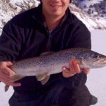
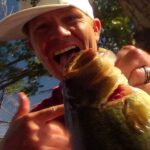
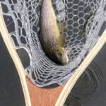
Primary Target: Rainbow Trout. Recent DWR stocking efforts have replenished the ponds with healthy numbers of pan-sized Rainbows. These fish are schooling heavily and are highly receptive to both bait and hardware.
Secondary Target: Brook Trout. Wild and holdover Brook Trout thrive in the colder, oxygen-rich inlets. They boast stunning colors this time of year and are far more predatory than the freshly stocked Rainbows.
Sleeper Pick: Tiger Trout. Often overlooked by the casual angler, these Brown/Brook trout hybrids are the apex predators of this small water system. They lurk near undercut banks and submerged timber, waiting to ambush larger prey. If you want to catch a Tiger, you need to upsize your offering.
Baitfish & Forage Report: The primary forage base consists of aquatic invertebrates. We are seeing strong midge hatches in the early mornings, with caddis starting to emerge as the sun warms the water. Small leeches and sculpins hold near the rocky structures of the dam. Match your flies and lures to these natural food sources for the best results.
TACTICAL STRATEGY
Because these waters receive steady fishing pressure, a refined tactical approach is what separates a full stringer from a frustrating day. Here is exactly how to target these fish.
Where to Deploy
Focus your efforts on the transition zones. At Aspen Mirror Lake, bypass the easily accessible parking lot shoreline and walk toward the inlet where the meandering stream feeds the lake. The moving water creates a natural conveyor belt of food. Position yourself near the 4-to-6-foot drop-offs just outside the current seam. At Duck Creek Pond, target the deeper holes near the dam structure, especially as the sun gets high and fish seek thermal refuge.
Pro Tip:Because aquatic weed growth becomes incredibly dense later in the season, take advantage of the current sparse vegetation by working your lures closer to the bottom than you normally would.
Lure & Hardware Selection
Leave the heavy tackle at home; finesse is key in this clear alpine water.
Spinners: A 1/16 oz Panther Martin (Black body with a Gold blade) is lethal for Brook Trout in the creek sections. For the open ponds, a 1/8 oz Kastmaster in Silver/Blue will trigger aggressive reaction strikes from cruising Rainbows.
Jigs: A 1/32 oz marabou jig in olive or black, fished under a small casting bubble with a slow twitch-and-pause retrieve, perfectly mimics a swimming leech.
Bait Fishing Tactics
If you are soaking bait for stocked Rainbows, presentation matters.
Rigging: Use a slip-sinker rig (Carolina rig) with a 1/4 oz egg weight, a small barrel swivel, and an 18-to-24-inch leader of 4lb fluorocarbon.
Bait: Garlic-scented chartreuse or rainbow Trout Dough (PowerBait) is outperforming everything else. The long fluorocarbon leader ensures the bait floats above the emerging bottom weed layer, keeping it right in the trout's visual strike zone.
Natural Bait: A half nightcrawler threaded onto a size 8 baitholder hook, suspended exactly 3 feet below a small bobber, is highly effective when cast parallel to the shoreline drop-offs.
Pro Tip:When fishing dough bait, mold it into a teardrop shape rather than a perfect sphere. This causes the bait to spin seductively on the retrieve when you reel in to check your bait, often triggering a vicious strike from a following fish.
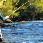
Fly Fishing Approach
For the fly angler, the glassy surface of Aspen Mirror Lake is a dream. In the early morning, cast a size 16 Parachute Adams or a Griffith's Gnat to rising fish. As the sun hits the water, switch to a sinking tip line and strip a size 8 Olive Woolly Bugger or a small bead-head nymph (like a size 14 Hare's Ear) through the deeper channels.
Timing
The golden hours are non-negotiable here. The best bite window is from first light until about 9:30 AM. Once the sun penetrates the clear, shallow water, the fish become easily spooked. The bite turns on again roughly an hour before sunset, culminating in a flurry of surface feeding activity.
REGULATIONS SNAPSHOT
Enforcement is strict in the Dixie National Forest, and ignorance of the law is not an excuse. Please review these critical rules before wetting a line:
Regulation Category
Details
Watercraft Restrictions
CRITICAL: Fishing from a boat, raft, or float tube is strictly UNLAWFUL on Duck Creek Springs Lake and Aspen Mirror Lake. Shoreline fishing and wading only.
Daily Bag Limit
4 Trout (combined total of all species).
Season
Open year-round, though access is severely limited by snowpack during winter months.
License Requirements
A valid Utah state fishing license is required for all anglers aged 12 and older.
REGIONAL ALTERNATIVE: PANGUITCH LAKE
If the shoreline at Duck Creek is too crowded, or if you brought a float tube and just realized you cannot launch it at Aspen Mirror, your backup plan is only a short drive away. Panguitch Lake is a premier destination located just 13 miles from Duck Creek Village.
Why Panguitch? The ice is completely off, and the post-ice-out bite is currently rated as excellent. Unlike Duck Creek, Panguitch allows motorized boating and float tubes, giving you access to much deeper water. The lake is famous for producing massive Rainbow, Cutthroat, and Tiger Trout.
Quick Tactical Approach for Panguitch: Troll pop-gear tipped with nightcrawlers along the 15-to-20-foot depth contours, or cast tube jigs and dark plastics near the rocky points. Keep in mind that Panguitch has a special slot limit to protect predatory fish: all Cutthroat and Tiger Trout between 15 and 22 inches must be immediately released. This protects the trophy fish that keep the invasive Utah Chub population in check.
Pro Tip:If you make the jump to Panguitch Lake, watch the wind. It can howl through the valley by mid-day, creating hazardous boating conditions. Get on the water at dawn for the safest and most productive experience.
Tight lines!
Editor's Choice: Must-Have Gear
FISHINGSIR Next-Gen Waterproof Chest Waders
★★★★★4.4 (7,370+ reviews)
2-Ply Tech: Upgraded nylon with 2.5x higher density than standard fabrics.
100% Waterproof: Lab-approved intrusion resistance with taped visible seams.
Ultra-Lightweight: Designed for all-day comfort while hunting or fishing.
As an Amazon Associate I earn from qualifying purchases. #ad
Loading forecast...
Live Fishing Conditions: Tides, Weather & Waves
Get real‑time tides, marine weather, swell and solunar activity for each spot so you know exactly when conditions line up for your best chance at a bite.
🎣
Duck Creek, Utah
Loading coordinates...
🌤️
WEATHER CONDITIONS
--°F
--°C
Loading...
🌡️
Feels Like--°F--°C
💧
Humidity--%
💨
Wind-- mph-- km/h
🧭
Direction--
📊
Pressure-- inHg-- hPa
☀️
UV Index--
🌊
MARINE CONDITIONS
🌊Wave Height
-- ft
-- m
Loading...
🧭Wave Direction
--°
Loading...
⏱️Wave Period
-- s
Loading...
📈Tide Status
-- ft
-- m
Loading...
🌙
LUNAR & SOLUNAR
🌕
Loading...
Illumination: --%
Major Period--:-- - --:----:-- - --:--
Minor Period--:-- - --:----:-- - --:--
🌅Sunrise--:--
🌇Sunset--:--
📅
24-HOUR FORECAST
Loading fishing conditions...
Fishing Spots Map
🎣
Book a Fishing Charter near Duck Creek, Utah Fishing Report Today 🎣
Local guides & charters. Verified captains, instant booking, best price guaranteed.
There was an error loading the map. Please try refreshing the page.
Info
Local Access & Facilities
The Fishery: Caribbean of the Rockies
Situated near Laketown and Garden City, the fishery surrounding Duck Creek and the greater Bear Lake basin offers a visual and tactical experience unlike anywhere else in the intermountain West. Experienced anglers know this water as the "Caribbean of the Rockies" due to its intense turquoise-blue hue, a phenomenon caused by the reflection of limestone deposits suspended in the water column. For the serious sportsman, this isn't just a scenic backdrop; it indicates a unique water chemistry that supports a specific ecosystem, including the endemic Bear Lake Cutthroat Trout and Lake Trout that grow to trophy sizes in these deep, mineral-rich waters.
The atmosphere here shifts dramatically with the seasons, offering a rugged versatility that appeals to year-round pros. In the summer, the placid, expansive waters can be deceptively calm before the warm afternoon winds kick up, challenging even the most capable hulls. Come winter, the area transforms into a hard-water arena, where ice fishing becomes the headline event. Whether you are trolling deep for Mackinaw or casting flies in the nearby Logan River, the environment is defined by high-elevation exposure and striking geological features, from the red sandstone banks of the river canyons to the white limestone shoals of the lake.
While the primary draw is the massive expanse of Bear Lake, the surrounding tributaries and reservoirs, such as the Logan River and Little Creek Reservoir, provide diverse opportunities for fly fishermen and light-tackle enthusiasts. The proximity of high-alpine diverse structures—ranging from steep conglomerate cliffs to rolling sagebrush uplands—requires anglers to be adaptable. This is a fishery that rewards those who understand the relationship between the unique bottom topography and the distinct water clarity that dictates leader visibility and lure presentation.
Access & Getting There
Reaching the prime fishing grounds around Laketown and Garden City requires navigating high-elevation routes that are as scenic as they are demanding. The primary artery from the west is U.S. Highway 89, winding through the dramatic limestone cliffs of Logan Canyon. While beautiful, this route can be slow-going during peak summer weekends or winter storms. For those towing heavy glass boats, be aware that the canyon roads are narrow with limited shoulders. From the Wyoming side, access via S.R. 30 from Sage Creek Junction offers a straighter shot, though it is equally exposed to crosswinds.
Bear Lake State Park serves as the logistical heart of boating operations in the area. Located just north of Garden City, the marina is the primary launch point for deep-draft vessels. The facility features paved boat ramps and slips designed to handle substantial fishing rigs. However, veteran skippers know that the "placid" description in tourist brochures often belies the reality of afternoon squalls; the sheer size of the lake allows chop to build quickly. Launching early—often before dawn—is not just a strategy for the bite, but a necessity to beat the mid-morning trade winds that can make trailering a challenge.
💡 Captain's Tip: Wind Awareness
The turquoise waters of Bear Lake are deceptive. Local afternoon winds can turn the lake into a washing machine quickly. When launching at the State Park Marina, plan your return leg before 1:00 PM to avoid the heaviest chop, especially if you are navigating a smaller craft or bass boat.
Parking infrastructure is robust but fills rapidly during the summer season. The Bear Lake Rest Area, located approximately 8.6 miles from the main fishing grounds, and the Bear Lake Overlook (15.1 miles out) offer staging options, but for direct trailer parking, the State Park Marina is the priority. Access to the river sections, particularly near Red Banks Campground, involves turning off U.S. 89 onto forest roads. These routes are generally well-maintained but can be washboarded; secure your trailer straps and transom savers tight before leaving the pavement.
Duck Creek, Utah Pre-Trip Checklist
Facilities & Amenities
The infrastructure around Duck Creek and Garden City caters well to the self-sufficient angler, though specialized services are concentrated in specific hubs. For heavy gear and local intelligence, Bear Lake Boating in Garden City is a primary resource. They operate extended hours (9:00 AM to 8:00 PM daily), making them accessible for mid-trip adjustments, though early risers will need to have their bait and ice sorted the night before. For those targeting the river systems, Cottonwood Fly Fishing in Cokeville provides specialized charter services and local knowledge on hatch timings and water flows.
Lodging options range from primitive staging areas to comfortable mountain retreats. Beaver Creek Lodge offers a higher-end base camp roughly 19 miles from the water, ideal for crews who prefer a soft bed after a hard day on the throttle. However, for the "dawn patrol" crowd, the local campgrounds offer the best strategic advantage. Sunrise Campground, sitting at 7,800 feet, is paved and offers yurts, which can be a game-changer during the colder shoulder seasons. It is important to note that while some campgrounds like Sunrise have drinking water and vault toilets, others like Little Creek Campground are more primitive, requiring you to pack in all necessary supplies.
💡 Captain's Tip: Trailer Logistics
If you are towing a long rig, prioritize Red Banks Campground or Sunrise Campground. Red Banks offers spurs up to 58 feet, while Sunrise has pull-throughs accommodating up to 30-35 feet. Always check the spur length before booking, as some older loops are tight for modern boat trailers.
Anglers should be aware of the "negative knowledge" regarding fuel and provisions. While the marina has facilities, fuel docks can have variable hours or long queues. It is highly recommended to fuel up your vessel on the highway in Garden City or Laketown before launching. Additionally, shore power and water hookups are not universal across all campsites; Red Banks and Sunrise campgrounds specifically list "No" for water hookups at individual sites, so fill your fresh water tanks before settling in.
Campground Facility Specifications
Facility Name
Elevation
Max Vehicle Length
Hookups
Key Features
Sunrise Campground
7,800 ft
18' - 35' (Select Sites)
No Water/Electric
Paved roads, Yurts available, near Bear Lake Summit.
Red Banks Campground
N/A (River Level)
20' - 58'
No Water/Electric
Located on Logan River, red sandstone cliffs, privacy shrubs.
Little Creek Campground
6,380 ft
30' - 75'
No Water/Electric
Gravel surface, staging for OHV/Fishing, primitive.
Permits, Regulations & Fees
Navigating the regulatory landscape here requires attention to detail, primarily because the Bear Lake fishery straddles the Utah-Idaho border. While the access points discussed here are largely in Utah, anglers trolling the main lake must be cognizant of state lines. A valid fishing license from the State Fishing Agency is mandatory. Due to the presence of endemic species like the Bear Lake Cutthroat, strict size and possession limits are often enforced to ensure the sustainability of the trophy fishery. Always consult the latest guidebook for seasonal closures, particularly around spawning tributaries.
The Cokeville Meadows National Wildlife Refuge to the north represents a critical conservation zone. Established to protect waterbird habitat and wet meadows, this area operates under strict federal oversight. While fishing is allowed, it is secondary to the wildlife management goals. Access is limited to compatible uses, and much of the land is held in conservation easements. Respecting private property boundaries and refuge signage is not just a legal requirement but a matter of preserving angler access to these sensitive riparian zones.
Camping and day-use fees are standard across the Uinta-Wasatch-Cache National Forest and Bear Lake State Park facilities. Cancellation policies are strict, with service fees applied for changes made within specific windows (typically 14 days for group facilities). It is worth noting that the "America the Beautiful" Senior and Access passes may provide discounts on single-family campsites, but generally do not apply to hookup fees or group sites. Carry cash for self-pay stations at primitive sites like Little Creek to avoid compliance issues.
Events & Seasonal Information
The rhythm of this fishery is dictated by the extremes of the high-desert climate. Summer is the peak season for open-water angling, with the famous turquoise waters drawing heavy recreational traffic. For the serious angler, this means the best fishing windows are early morning or late evening, avoiding the midday watersports congestion. The biological clock of the lake is driven by the water temperature; as the surface warms, Lake Trout retreat to the depths, requiring downriggers and precise depth control to find success.
Winter brings a complete transformation. The area is renowned for ice fishing, targeting the same trophy species through the hard deck. The Bear Lake Monster Winterfest is a cultural staple, but for the purist, the draw is the solitude of the frozen lake. Snowmobiling is also a major draw, with trails accessible from hubs like the Beaver Mountain Ski Area. If you are planning a trip during the shoulder seasons (late fall or early spring), be prepared for rapid weather changes. The high elevation at passes like Bear Lake Summit means snow can impact towing conditions well into late spring.
💡 Captain's Tip: Seasonal Water Levels
In the agricultural corridors near Cokeville, water management for hay production significantly impacts river flows. Late summer irrigation drawdowns can lower water levels in meadows and tributaries, concentrating fish but also making them spookier. Adjust your tackle to lighter tippets and stealthier approaches during the August haying season.
Contact Information & Resources
For real-time conditions and emergency assistance, maintain a list of local agency contacts. The Bear Lake State Park office can be reached at 435-946-3343 for marina conditions and ramp status. For camping inquiries and forest road conditions in the high country, contact the Logan Ranger District at 435-755-3620 or the Utah Recreation Company at 385-273-1100.
In the event of an emergency, cell service can be spotty in the canyons and on the far side of the lake. Self-reliance is key. Ensure your vessel is equipped with required safety gear and that your tow vehicle is prepped for mountain grades. For wildlife refuge specific regulations, the Cokeville Meadows NWR can be contacted via the Seedskadee office at 307-875-2187.
For precise locations of boat ramps, real-time weather data, and detailed bathymetry, consult the live dashboard and interactive maps below.
Our spot reports combine data-driven forecasts with curated local information. The forecast is generated by our proprietary Fishing Score algorithm (0–100%), which analyzes real-time data from Open-Meteo API, validated against NOAA CO-OPS tide gauges and USGS water-monitoring stations. The model weights tide dynamics (35%), wave energy (25%), wind patterns (20%) and time of day (20%)—factors shown to influence fish feeding behavior through marine-biology research and decades of charter log data.
Access, facilities and services information for each fishing spot is sourced from official datasets such as Recreation.gov (RIDB), state park & wildlife agencies, and geospatial providers like Google Maps. These sections undergo scheduled re-validation every 3–6 months to ensure that boat ramps, park access, contact details and local services remain accurate.
Narrative sections (catches, seasonal behavior, local tips) are synthesized from these data sources and refined following the Fishing Reports Today editorial guidelines, combining bibliographic research from ichthyology and oceanography with expert angler experience. Our team reviews reports on a regular basis, while the forecast model itself updates every 6 hours for real-time accuracy.
⚠️ Important: Always verify current local regulations, access restrictions and weather conditions before fishing. These reports are intended as a planning aid, not a guarantee of catches or safety. When in doubt, contact local authorities or park managers listed on the page.
To provide the best experiences, we use technologies like cookies to store and/or access device information. Consenting to these technologies will allow us to process data such as browsing behavior or unique IDs on this site. Not consenting or withdrawing consent, may adversely affect certain features and functions.
Functional Always active
The technical storage or access is strictly necessary for the legitimate purpose of enabling the use of a specific service explicitly requested by the subscriber or user, or for the sole purpose of carrying out the transmission of a communication over an electronic communications network.
Preferences
The technical storage or access is necessary for the legitimate purpose of storing preferences that are not requested by the subscriber or user.
Statistics
The technical storage or access that is used exclusively for statistical purposes.The technical storage or access that is used exclusively for anonymous statistical purposes. Without a subpoena, voluntary compliance on the part of your Internet Service Provider, or additional records from a third party, information stored or retrieved for this purpose alone cannot usually be used to identify you.
Marketing & Affiliates
The technical storage or access is required to create user profiles to send advertising, or to track the user on a website or across several websites for similar marketing purposes, including affiliate tracking for products recommended in our reports.


Leave a Reply