


The Mogollon Rim Lakes represent a dramatic geological and atmospheric shift from the arid deserts below. Rising to an elevation of 7,500 feet within the Apache-Sitgreaves National Forest, this region offers a cool, pine-scented sanctuary that stands in stark contrast to the heat of the Phoenix valley. For the serious angler, this is not merely a scenic escape; it is a high-altitude trout fishery defined by its specific topography. The Rim itself—a massive escarpment stretching 200 miles—creates a unique weather and water environment where deep blue reservoirs sit amidst ponderosa pines, oak, and Douglas fir.
The atmosphere here is distinctly alpine. The air is thin and crisp, and the water temperatures remain conducive to trout survival even during the height of the Arizona summer. Unlike the vast, powerboat-dominated reservoirs of the lower Salt River chain, the lakes along the Rim, particularly Woods Canyon Lake and Willow Springs Lake, offer a quieter, more technical experience. The vibe is rugged yet accessible, characterized by the scent of damp pine needles and the sound of wind rushing up the face of the escarpment. It is a place where the dawn patrol requires a jacket in July and where the afternoon sky can turn volatile in minutes.
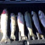
The primary draw for expert anglers here is the trout—stocked rainbow trout and the occasional brown trout that hold over in the deeper channels. While these waters are heavily pressured due to their accessibility, success lies in understanding the nuances of the weekly stocking schedules and the specific bottom structures of the lakes. Woods Canyon Lake, covering 52 acres, is the crown jewel of the area, offering a mix of shore access and boatable water that demands finesse. Whether you are stripping woolly buggers from a float tube or trolling spinners from a small aluminum hull, the Rim lakes require an adjustment in tactics and expectations suited to high-country angling.
Access & Getting There
Accessing the Mogollon Rim Lakes requires navigating a significant elevation gain, primarily via Highway 260. Most anglers approach from the west, coming from Payson. The drive is a steady climb, and traffic can be heavy on weekends, particularly with RVs struggling on the grades. The primary artery for the lakes is Forest Road 300 (the Rim Road), which turns off Highway 260 directly across from the Rim Visitor Information Station. This road traces the very edge of the escarpment, offering spectacular views that drop thousands of feet to the desert floor. While scenic, this route can be a bottleneck, and drivers must remain alert for elk which frequently cross the tarmac.
💡 Captain's Tip: Trailer Management
The main loop road at Spillway Campground has a notoriously tight turning radius hedged by trees. Experienced haulers know that no RV or trailer over 32 feet should attempt this loop. If you are hauling a larger rig, head directly to Canyon Point or Rim Campground to avoid a jackknife situation.
For those targeting Woods Canyon Lake, the turn onto Woods Canyon Lake Road is approximately 5 miles down Forest Road 300. The road is paved, facilitating easy access for boat trailers, but the parking situation requires strategic planning. The boat ramp parking lot at Woods Canyon Lake fills rapidly. During peak summer months, arriving by 5:00 AM is often necessary to secure a spot close to the water. Late arrivals may be forced to park in overflow areas significantly farther from the launch, complicating the logistics of gear transport.
Weather plays a critical role in access reliability. The area is prone to the "Monsoon" season, typically from late June through August. These are not gentle showers; they are violent afternoon thunderstorms that bring lightning and heavy downpours. Forest Road 300 and secondary gravel access points can become slick and treacherous during these events. Furthermore, the wind often whips up the face of the Rim in the late morning. Anglers in small craft or kayaks must be vigilant, as the calm morning glass can transform into dangerous chop by 10:00 AM. It is advisable to launch at first light and plan to be off the water or in a sheltered cove by midday.
Parking facilities vary by specific location. The Horton Springs Parking Lot is a distant overflow option located over 15 miles away near Payson, making it irrelevant for immediate lake access. For direct access, stick to the designated lots at the Woods Canyon Lake Store and Marina or the day-use areas at Canyon Point. Be aware that the Rim Campground and Spillway Campground have strict vehicle limits per site, usually capped at two vehicles. If you are meeting a crew, carpooling from Forest Lakes is a logistical necessity.
Mogollon Rim Lakes Pre-Trip Checklist
Facilities & Amenities
The infrastructure around the Mogollon Rim Lakes is well-developed but specific in its offerings. For on-the-water needs, the Woods Canyon Lake Store and Marina is the logistical hub. Located directly on the water, this facility offers boat rentals (including kayaks and electric-motor boats) and basic groceries. It is the only immediate source for bait and tackle on the lake, making it indispensable for last-minute re-rigging. However, seasoned captains know that prices here reflect the convenience; stocking up on heavy supplies in Payson or Forest Lakes is more economical.
For broader provisioning, Gilligan's Forest Lakes General Store, located about 2 miles east of Canyon Point on Highway 260, serves as a vital outpost. This location offers fuel, telephones, and a wider selection of groceries. It is the nearest reliable fuel stop; anglers should note that there is no fuel dock on the lake itself. If you are running a generator for your RV or camping setup, ensure your jerry cans are filled here before heading deep into the dispersed camping areas along Forest Road 300.
💡 Captain's Tip: Shower Logistics
Do not expect showers at Spillway Campground or Rim Campground. If a hot shower is a non-negotiable part of your trip, you must book at Canyon Point Campground, which is 10 miles away from the lake. Plan your accommodation accordingly to avoid hygiene surprises.
The camping facilities are divided by utility and location. Canyon Point Campground is the largest and most robust facility, featuring 113 campsites, 32 of which have electricity. It can accommodate larger rigs up to 75 feet and includes showers and a dump station. In contrast, Spillway Campground offers a premium location right on the shores of Woods Canyon Lake but with significantly reduced amenities—vault toilets only and no electrical hookups. Rim Campground offers a middle ground with 26 sites and spectacular views, but like Spillway, it relies on vault toilets and has no hookups.
The table below details the specific capabilities of the local facilities to help you choose the right base of operations:
| Facility Name | Type | Key Features | Max Vehicle Length | Distance to Lake |
|---|---|---|---|---|
| Canyon Point | Campground | Showers, Electric Hookups (32 sites), Dump Station | 75 ft | 5 miles |
| Spillway (AZ) | Campground | Lakeside access, Vault Toilets, Tight Turns | 32 ft (Recommended) | 0 miles (On Shore) |
| Rim Campground | Campground | Rim Views, Vault Toilets, Parallel Parking | 32 ft | 3 miles |
| Woods Canyon Marina | Store/Marina | Boat Rentals, Groceries, Bait | N/A | 0 miles (On Shore) |
Lodging outside of campgrounds is limited in the immediate vicinity. Five Lakes RV Park offers full hookups about 3 miles away in Forest Lakes. For those seeking cabins or hotels, the nearest full-service community is Overgaard, located 22 miles east, or Payson, 35 miles to the west. This distance makes "dawn patrol" launches difficult if you are not staying at one of the forest campgrounds.
Permits, Regulations & Fees
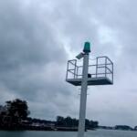
Fishing and boating on the Rim are governed by strict regulations designed to protect the resource and the serenity of the high-country experience. The most critical regulation for boaters at Woods Canyon Lake is the motor restriction. This is an electric-motor-only lake. Gas motors may be mounted on your boat, but they must be tilted up and out of the water at all times. There is no wake allowed. This rule is strictly enforced to maintain the quiet atmosphere and water quality. If you are bringing a bass boat, ensure your trolling motor batteries are fully charged and you have backups.
All anglers must possess a valid Arizona fishing license with a trout stamp. The area is managed by the Apache-Sitgreaves National Forest, and while entry to the forest is generally free, the developed recreation areas have fees. The campgrounds—Canyon Point, Rim, and Spillway—all require reservations or daily fees. Rim Campground reserves sites 14 through 26 for advanced booking, while others may be first-come, first-served, though availability is rare on weekends. Canyon Point and Spillway are heavily reservation-based via official channels.
💡 Captain's Tip: Fire Restrictions
The Mogollon Rim is a high-fire-risk zone. "Kapu" (forbidden) areas regarding fire are common. Always check current fire restrictions before towing up. During Stage 2 restrictions, even charcoal grills in developed campgrounds are prohibited, and you will be limited to propane only.
Cultural respect and conservation are paramount. The Rim holds historical significance, and the delicate high-desert ecosystem takes decades to recover from damage. Off-road driving is strictly prohibited to prevent erosion of the fragile soil. Visitors should also be aware of the "Bear Aware" regulations; food storage rules are enforced to prevent habituating the local black bear population. Trash service is provided at the campgrounds, and packing out what you pack in is the standard etiquette for all day-use areas.
Events & Seasonal Information
The rhythm of the Rim is dictated by the seasons. The prime fishing season runs from late spring through early autumn. Summer daytime temperatures are pleasant, generally running 20 to 40 degrees cooler than the Phoenix metro area, making it a magnet for desert dwellers. However, the "Monsoon" season brings a predictable and violent weather pattern. From July through August, mornings are typically calm and clear, but cumulus clouds build rapidly by 11:00 AM, leading to severe thunderstorms with dangerous lightning in the early afternoon. Boaters must keep an eye on the sky and be prepared to get off the water instantly.
While there are no major professional bass tournaments due to the electric-motor restrictions, the area is popular for community trout derbies and educational programs. The Canyon Point Amphitheater frequently hosts educational programs given by Forest Service rangers on weekends, which can be a great activity for families after a morning of fishing. The stocking schedule is the unofficial "event" calendar for the lake; Woods Canyon Lake is stocked weekly during the summer, usually early in the week. Anglers in the know track these stockings to time their trips for the most aggressive bites.
Wildlife viewing is a secondary seasonal attraction. Elk are frequently seen wandering through Rim Campground and Spillway, particularly at dawn and dusk. This adds to the ambiance but requires caution when driving Forest Road 300 in low light. The cool nights, even in summer, require appropriate clothing. It is not uncommon for temperatures to drop into the 40s or 50s at night, necessitating layers for early morning launches.
Contact Information & Resources
For the most current information regarding campground status, fire restrictions, and road conditions, direct contact with the managing agencies is essential. The facilities are located within the Apache-Sitgreaves National Forest. Specific facility information for Canyon Point, Rim, and Spillway can be obtained by calling (928) 535-0181. For reservation issues or specific site questions, the direct line is 928-535-9859.
In terms of safety, self-reliance is key. Cell phone service is spotty at best along the Rim and often non-existent in the canyon bottoms. Gilligan's Forest Lakes General Store (Phone: (928) 535-4716) is a good local contact for immediate supply questions. The nearest full emergency services are in Payson. Always leave a float plan with someone back home, as the remote nature of the dispersed camping areas and the volatile weather can lead to unexpected delays.
For precise locations, real-time weather data, and detailed maps of the boat ramps and amenities discussed here, consult the interactive live dashboard and maps below.


Leave a Reply