Verdict: GO - PROCEED WITH STANDARD ALPINE CAUTION
As we transition fully into the early summer season, the ice has officially retreated from Continental Reservoir, revealing 150 acres of pristine, high-alpine water. Situated at a towering 10,250 feet in the Rio Grande National Forest of Hinsdale County, this irrigation impoundment is primed for open-water action. Forest Road 513 is clear of major winter snowpack, though anglers should anticipate muddy, rutted sections typical of the early-season thaw. A high-clearance, four-wheel-drive vehicle is highly recommended to safely navigate the final miles to the dam structure.
Weather at this extreme altitude is notoriously fickle and demands respect. While mornings are generally calm, crisp, and clear, the standard Rocky Mountain pattern of violent, fast-moving afternoon thunderstorms is already in full effect. Anglers utilizing kayaks, float tubes, canoes, or motorized boats should plan to be off the water by early afternoon to avoid dangerous lightning strikes and hazardous, swirling high winds. Water temperatures are still hovering in the low 40s; cold-water immersion is a serious threat, so wear your personal flotation device (PFD) at all times.
🎣Nautrek
Private Beta
J
M
R
100+ anglers on the waitlist
The fishing network where your reputation matters.
Find trusted captains, join real trips with cost splitting, and build your Angler Rank. Your spots stay private — you decide who sees your intel.
Understanding the hierarchy of the food chain at Continental Reservoir is critical to a successful trip. Here is a quick breakdown of what you will encounter:
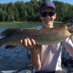
Colorado Parks and Wildlife (CPW) actively manages this fishery with heavy, consistent stockings of catchable-sized Rainbow Trout and Snake River Cutthroat Trout. The current population density is incredibly robust, with the vast majority of fish falling into the 10 to 14-inch class, though holdovers from previous seasons frequently push the 16 to 18-inch mark. Because the water temperatures are still frigid following the recent ice-off, these trout are highly active. They have shaken off their winter lethargy and are actively gorging on emerging forage to regain lost body mass. You will find them cruising the main basin in loose schools, typically suspending just a few feet above the bottom structure.
Sleeper Pick: Brook Trout
While the masses focus their efforts on the freshly stocked rainbows near the boat ramp and the deep water, the naturally reproducing Brook Trout are the true hidden gems of Continental Reservoir. These vibrantly colored, crimson-slashed fish often push out of the main basin and aggressively hunt in the shallow margins. They are opportunistic, highly territorial, and provide fantastic light-tackle sport for anglers willing to step away from the crowd.
Baitfish and Forage Report
At an elevation exceeding 10,000 feet, traditional baitfish populations—such as shad, shiners, or fathead minnows—are virtually nonexistent. The primary forage base for all trout species here consists entirely of aquatic macroinvertebrates. Chironomids (midge larvae) are the dominant food source right now, alongside early-season freshwater scuds hiding in the decaying shallow weed beds left over from last year. As the water continues to warm over the coming weeks, expect to see the first early hatches of small mayflies and caddisflies. To induce consistent strikes, you must match your presentations to these micro-forage profiles.
TACTICAL STRATEGY
Where to Deploy
For the stocked Rainbows and Cutthroats, focus your efforts on the deeper basin accessible via the concrete boat ramp on the east side of the reservoir. Use your electronics to locate the 15 to 25-foot depth bands where the bottom transitions from soft mud to scattered rock and gravel. This transition zone is a natural highway for cruising trout.
For the sleeper Brook Trout, abandon the deep water entirely and head toward the North Clear Creek inlet on the western edge of the reservoir. Work the 4 to 8-foot drop-offs and the edges of the emerging weed lines. The moving water from the inlet brings a constant, highly oxygenated conveyor belt of nutrients into the lake, stacking aggressive brookies in the shallows waiting to ambush prey.
Lure and Fly Selection
Spin anglers should rely on a 1/8oz Kastmaster, a 1/16oz Thomas Buoyant spoon, or a Rapala Jigging Rap #5. These heavy, compact lures allow for long casts in the wind and fast sink rates to reach suspended fish. For fly anglers, indicator nymphing is the most productive method right now. Suspend a size 18 Zebra Midge, a size 20 Blood Midge, or a size 14 Olive Scud about one to two feet off the bottom. If the wind dies down, stripping a size 10 Olive Woolly Bugger on an intermediate sinking line can trigger aggressive reaction strikes.
Color Patterns
Water clarity is currently pristine, boasting classic high-alpine blue hues with visibility exceeding ten feet. Under these clear conditions, opt for natural, flashy colors. Silver and blue Kastmasters mimic the flash of a struggling trout fry or a large ascending insect, while olive, brown, and black are mandatory for your scud and midge fly patterns to accurately match the natural hatch.
Bait and Rigging
If you prefer static bait fishing from the shoreline, simplicity and stealth are key. A classic sliding sinker rig (often called a Carolina rig) is highly effective. Use a 1/4oz egg weight above a small barrel swivel, followed by an 18 to 24-inch fluorocarbon leader in 4lb test. Cap it off with a size 8 baitholder hook loaded with a miniature marshmallow and a piece of nightcrawler, or floating PowerBait in garlic or chartreuse flavors. The floating bait ensures your presentation stays above the bottom moss and directly in the trout's visual strike zone.
Pro Tip: When targeting the cruising rainbows in the basin with hardware, always tip the treble hook of your spoon or your tungsten jigs with a single waxworm, mealworm, or a spike. That tiny addition of scent and natural protein is often the deciding factor for short-striking fish that follow your lure to the boat but refuse to commit.
Timing the Bite
The golden hours of dawn and dusk remain supreme, offering the most aggressive feeding windows. However, because the water is still incredibly cold, the bite often extends well into the mid-morning as the sun begins to warm the shallow flats, activating the insect life.
Pro Tip: Cloud cover is your best friend at this extreme elevation. A bright, bluebird sky will push the trout deep to protect their sensitive eyes from the intense UV penetration. If a thick cloud bank rolls in, expect the fish to immediately push shallower and feed more aggressively. Always have a rod rigged and ready for these sudden low-light windows.
REGULATIONS SNAPSHOT
Continental Reservoir is managed under standard Colorado Parks and Wildlife statewide fishing regulations, but it is always critical for anglers to stay compliant and protect the resource:
Bag and Possession Limits: The daily bag limit for trout is 4 fish, with a total possession limit of 4 fish.
Size Limits: There are no minimum size restrictions for trout on this body of water.
Season Status: The reservoir is open to fishing year-round, though access is heavily dictated by winter snow conditions.
Boating Regulations: Both motorized and non-motorized boats are permitted on the water. However, all motorized vessels must operate at strictly wakeless speeds to protect the shoreline and smaller craft.
Licensing: A valid Colorado fishing license is required for all anglers aged 16 and older.
REGIONAL ALTERNATIVE
Rito Hondo Reservoir
If Continental Reservoir is blown out by dangerous high winds, or if the main boat ramp area is simply too crowded for your liking, Rito Hondo Reservoir serves as an exceptional, immediate fallback option. Located just 3 miles southeast along Forest Road 513, this smaller, more intimate State Wildlife Area impoundment offers excellent protection from the prevailing westerly winds due to the surrounding dense spruce-fir forest.
Rito Hondo is heavily stocked with Brook and Rainbow trout and features a much softer, muddier bottom composition compared to Continental. Because it is shallower and more protected, the water temperature warms slightly faster, often accelerating the insect hatches.
Tactical Approach: Ditch the heavy deep-water hardware. Switch to a clear plastic water bubble trailing a size 14 Pistol Pete, a small Panther Martin spinner, or a black Woolly Bugger. Cast parallel to the shoreline, particularly near the inlet creek on the north end, and use a slow, erratic retrieve to trigger vicious strikes from the resident brookies holding in the submerged timber.
Pro Tip: Moose are extremely active in the North Clear Creek drainage between Continental and Rito Hondo. Always maintain a safe distance and never position yourself between a cow and her calf while walking the banks to access your fishing spots.
Tight lines!
Editor's Choice: Must-Have Gear
FISHINGSIR Next-Gen Waterproof Chest Waders
★★★★★4.4 (7,370+ reviews)
2-Ply Tech: Upgraded nylon with 2.5x higher density than standard fabrics.
100% Waterproof: Lab-approved intrusion resistance with taped visible seams.
Ultra-Lightweight: Designed for all-day comfort while hunting or fishing.
As an Amazon Associate I earn from qualifying purchases. #ad
Loading forecast...
Live Fishing Conditions: Tides, Weather & Waves
Get real‑time tides, marine weather, swell and solunar activity for each spot so you know exactly when conditions line up for your best chance at a bite.
🎣
Continental Reservoir
Loading coordinates...
🌤️
WEATHER CONDITIONS
--°F
--°C
Loading...
🌡️
Feels Like--°F--°C
💧
Humidity--%
💨
Wind-- mph-- km/h
🧭
Direction--
📊
Pressure-- inHg-- hPa
☀️
UV Index--
🌊
MARINE CONDITIONS
🌊Wave Height
-- ft
-- m
Loading...
🧭Wave Direction
--°
Loading...
⏱️Wave Period
-- s
Loading...
📈Tide Status
-- ft
-- m
Loading...
🌙
LUNAR & SOLUNAR
🌕
Loading...
Illumination: --%
Major Period--:-- - --:----:-- - --:--
Minor Period--:-- - --:----:-- - --:--
🌅Sunrise--:--
🌇Sunset--:--
📅
24-HOUR FORECAST
Loading fishing conditions...
Fishing Spots Map
🎣
Book a Fishing Charter near Continental Reservoir Fishing Report Today 🎣
Local guides & charters. Verified captains, instant booking, best price guaranteed.
There was an error loading the map. Please try refreshing the page.
Info
Local Access & Facilities
The Alpine Frontier: Fishing Continental Reservoir
Sitting high in the San Juan Mountains at an elevation over 9,200 feet, Continental Reservoir represents the quintessential high-country fishery. This is not a manicured urban lake; it is a rugged, alpine destination that demands preparation and respect from even the most seasoned anglers. Surrounded by the Rio Grande National Forest and sitting adjacent to the massive Weminuche Wilderness, the location offers a raw, quiet atmosphere where the silence is broken only by the sound of drag screaming from a hooked trout or the wind moving through the spruce and aspen groves.For the expert angler, the draw here is the solitude and the opportunity to target Brown and Rainbow Trout in a setting that feels miles removed from civilization. The water here is cold, clear, and fed by the snowmelt of the Continental Divide. Unlike the crowded reservoirs closer to the Front Range, this spot requires a logistical commitment to reach, ensuring that those who make the trek are serious about their craft. The environment is characterized by volcanic rock bluffs, dense willows along the banks, and expansive meadows that bloom briefly but intensely during the short summer season.
💡 Captain's Tip: High Altitude Calibration
You are launching at over 9,000 feet. Ensure your outboard is tuned for high-altitude performance to avoid sluggish starts. Additionally, the sun is significantly more intense here; polarized eyewear is not just for spotting fish, but essential for eye protection against the high-UV glare off the water.
Access & Getting There
Reaching Continental Reservoir and its surrounding waters requires navigating the rugged topography of Hinsdale and Mineral Counties. The primary gateway is the historic mining town of Creede. From Creede, anglers typically travel west on Highway 149 for approximately 20 miles before turning onto Forest Road 520 (Rio Grande Reservoir Road). This final stretch is a gravel road that winds through the valley. While generally well-maintained, the washboard surface can be punishing on boat trailers. Experienced haulers know to lower their tire pressure slightly to absorb the vibration and prevent frame fatigue on lighter aluminum boat trailers.Traffic in this region is generally light, but the road can become narrow in sections, particularly when navigating around the River Hill area. The drive itself is scenic but demands driver attention, especially during early morning "dawn patrol" runs when wildlife, particularly elk and deer, are active near the roadway. The route takes you past the headwaters of the Rio Grande, offering a visual preview of the water conditions before you even reach the launch.Boat access is facilitated primarily through the River Hill area, located roughly 10 miles from the main reservoir body. The launch facilities here are functional but rustic. Do not expect paved, multi-lane mega-ramps. The access points are gravel and natural surface launches suitable for trailered fishing boats and drift boats, but skippers with heavy deep-V glass boats should exercise extreme caution, particularly late in the season when water levels fluctuate. The River Hill Campground serves as a primary staging area, offering proximity to the water that allows for quick access at first light.
💡 Captain's Tip: Trailer Security
The gravel roads leading to the reservoir are notorious for kicking up rocks. Seasoned captains utilize rock guards or "bow buddies" on their trailers to protect the gel coat or aluminum hulls. Always carry a full-size spare tire for the trailer; cell service is non-existent in many pockets along Forest Road 520.
Weather is the single biggest variable for access in this region. The San Juan Mountains create their own weather systems. A sunny morning can turn into a violent thunderstorm by 1:00 PM. The road, while passable in dry conditions, can become slick and treacherous during heavy rains. During the shoulder seasons, snow can accumulate rapidly, making the pass impassable for vehicles without 4x4 capabilities. The Alpine Loop, a famous backcountry byway connecting Lake City and Silverton, is nearby and offers 4x4 access to even more remote waters, but it is strictly for high-clearance off-highway vehicles.
Continental Reservoir Pre-Trip Checklist
Facilities & Amenities
The infrastructure around Continental Reservoir is designed for the self-reliant sportsman. This is "pack it in, pack it out" territory. The nearest substantial amenities are located back in Creede, roughly 20 to 25 miles away. Anglers should be aware that there is no fuel dock on the water and no gas station immediately adjacent to the boat ramps. Topping off your truck and boat tanks in Creede or Lake City is a mandatory part of the pre-trip logistics.For tackle and local intelligence, the Ramble House on North Main Street in Creede is a vital resource. Rated highly by locals, this shop opens at 10:00 AM during the week. While this is too late for picking up bait on the way to a morning bite, it is the place to stop the day before to get the specific fly patterns or lures that are working currently. Similarly, Rio Grande Angler offers charter services and gear advice. These shops are staffed by guides who understand the specific seasonal hatches of the Lake Fork and Rio Grande headwaters.Camping is the primary accommodation style for anglers fishing this water. River Hill Campground and Thirty Mile Campground are the two official Forest Service facilities supporting the area. River Hill Campground:This facility is situated directly on the banks of the Rio Grande River. It features vault toilets and drinking water from wells but offers no electric hookups. This is a critical detail for boaters relying on trolling motors; you must have a generator or an alternator charging system to keep your battery banks topped off for a multi-day trip. The campground has specific sites (like Site 005 and Site 011) that can accommodate vehicles and trailers up to 25 and 125 feet respectively, though most sites are back-in gravel pads best suited for lengths under 45 feet.Thirty Mile Campground:Located slightly further out, this campground is nestled among spruce and aspen trees. Like River Hill, it provides drinking water and vault toilets but lacks electrical hookups. It serves as an excellent overflow option or a base for those who prefer a more wooded setting. The sites here, such as Site 030, can handle equipment up to 50 feet, making it viable for larger fishing rigs.For those requiring hard-sided lodging or full hookups, the Bristol Mountain RV Park & Cabins offers a more civilized base camp about 14 miles away. Alternatively, the Oleo Ranch offers accommodation closer to the Lake City side. However, utilizing these lodges adds significant travel time to your fishing day compared to staying at the Forest Service campgrounds.
💡 Captain's Tip: Ice Management
There is no ice sold at the boat ramps or campgrounds. High-quality rotomolded coolers are essential here. Pre-chill your coolers and use block ice rather than cubes to ensure your catch and provisions survive a 3-day weekend in the high-altitude sun.
Permits, Regulations & Fees
Fishing in this zone falls under the jurisdiction of Colorado Parks and Wildlife (CPW), while the land and access points are managed by the Rio Grande National Forest and the Bureau of Land Management (BLM). A valid Colorado fishing license is mandatory for all anglers.Conservation & Wilderness Boundaries:A critical aspect of fishing this area is its proximity to the Weminuche Wilderness and the Powderhorn Wilderness Area. The Weminuche is the largest wilderness area in Colorado. Anglers must be acutely aware of their location relative to the wilderness boundary. While motorized boats are permitted on the reservoir and specific access points outside the boundary, crossing into designated Wilderness areas with any motorized equipment (including generators or chainsaws) is a federal offense.Protected Zones & Ethics:The Lake Fork of the Gunnison River, which offers approximately 14 miles of public access, is a sensitive ecosystem. The Colorado Division of Wildlife stocks this water with fingerling and catchable trout, including Kokanee salmon in the fall. Anglers should pay close attention to specific catch limits and possession rules which can vary by season to protect spawning populations. The "Leave No Trace" ethos is strictly enforced here. This includes disposing of fishing line properly to protect waterfowl and packing out all trash. The high-alpine tundra is fragile; driving off designated roads (like FS 520) to find a "better" launch spot causes lasting environmental damage and can lead to hefty fines.
Events & Seasonal Information
The fishing calendar at Continental Reservoir is dictated entirely by the freeze-thaw cycle of the high Rockies. The season is short, typically running from late May, once the ice recedes and the roads dry out, through October.Summer Patterns:July and August are the peak months. During this time, the "monsoon" pattern is the dominant rhythm. Experienced skippers know to be off the open water by early afternoon to avoid the dangerous lightning storms that roll over the San Juan peaks. The wind usually picks up around 10:00 AM, making early morning the prime window for topwater action or delicate fly presentations.Fall Transitions:September brings the changing of the aspens, turning the hillsides gold. This is often the best time for targeting large Brown Trout as they prepare for the spawn. The water temperatures drop, and the fish become more aggressive. However, this is also when hunting seasons begin. Anglers utilizing River Hill or Thirty Mile campgrounds in the fall should be aware that they will be sharing the space with hunters. Wearing blaze orange, even when fishing from the shore, is a prudent safety measure during rifle seasons.Winter Access:Once the snow falls, usually by November, access becomes restricted to snowmobiles and tracked vehicles. The reservoir freezes over, offering ice fishing opportunities for the adventurous, but the Forest Service roads are not plowed for standard vehicle traffic.
Contact Information & Resources
For the most current information regarding road closures, fire bans, and campground status, anglers should contact the managing agencies directly before hitching up the boat.Campground Management (PMC Parks): 719-658-0829BLM Gunnison Field Office: 970-642-4940* Emergency Services: Dial 911 (Note: Satellite phones or SPOT devices are recommended as cell service is unreliable).Safety in this region is about self-reliance. The nearest hospital is a significant distance away. Always file a float plan with someone back home, detailing your intended launch and return times.For precise locations of the gravel ramps, specific depth contours, and real-time weather alerts for the Continental Reservoir area, consult the live dashboard and interactive maps below.
Our spot reports combine data-driven forecasts with curated local information. The forecast is generated by our proprietary Fishing Score algorithm (0–100%), which analyzes real-time data from Open-Meteo API, validated against NOAA CO-OPS tide gauges and USGS water-monitoring stations. The model weights tide dynamics (35%), wave energy (25%), wind patterns (20%) and time of day (20%)—factors shown to influence fish feeding behavior through marine-biology research and decades of charter log data.
Access, facilities and services information for each fishing spot is sourced from official datasets such as Recreation.gov (RIDB), state park & wildlife agencies, and geospatial providers like Google Maps. These sections undergo scheduled re-validation every 3–6 months to ensure that boat ramps, park access, contact details and local services remain accurate.
Narrative sections (catches, seasonal behavior, local tips) are synthesized from these data sources and refined following the Fishing Reports Today editorial guidelines, combining bibliographic research from ichthyology and oceanography with expert angler experience. Our team reviews reports on a regular basis, while the forecast model itself updates every 6 hours for real-time accuracy.
⚠️ Important: Always verify current local regulations, access restrictions and weather conditions before fishing. These reports are intended as a planning aid, not a guarantee of catches or safety. When in doubt, contact local authorities or park managers listed on the page.
To provide the best experiences, we use technologies like cookies to store and/or access device information. Consenting to these technologies will allow us to process data such as browsing behavior or unique IDs on this site. Not consenting or withdrawing consent, may adversely affect certain features and functions.
Functional Always active
The technical storage or access is strictly necessary for the legitimate purpose of enabling the use of a specific service explicitly requested by the subscriber or user, or for the sole purpose of carrying out the transmission of a communication over an electronic communications network.
Preferences
The technical storage or access is necessary for the legitimate purpose of storing preferences that are not requested by the subscriber or user.
Statistics
The technical storage or access that is used exclusively for statistical purposes.The technical storage or access that is used exclusively for anonymous statistical purposes. Without a subpoena, voluntary compliance on the part of your Internet Service Provider, or additional records from a third party, information stored or retrieved for this purpose alone cannot usually be used to identify you.
Marketing & Affiliates
The technical storage or access is required to create user profiles to send advertising, or to track the user on a website or across several websites for similar marketing purposes, including affiliate tracking for products recommended in our reports.


Leave a Reply