Conditions are prime for early summer angling across the Treasure Coast, but situational awareness is critical. We have fully transitioned into our classic Florida summer weather pattern. This means sweltering daytime temperatures, high humidity, and the daily threat of intense, fast-moving afternoon convective thunderstorms. Anglers heading offshore or fishing the St. Lucie Inlet need to keep a close eye on the radar after 2:00 PM. Hydration and sun protection are absolutely mandatory.
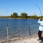
For those navigating the St. Lucie Inlet, be extremely cautious during an outgoing tide paired with a strong east wind, as the mouth can become treacherous with standing waves. Otherwise, the seas have been relatively calm during the morning hours, providing excellent windows for both offshore trolling and inshore flats fishing. To beat the heat and find the most active fish, focus your efforts on the first light of dawn, dusk, or night tides. Midday fishing will be sluggish as water temperatures peak.
From the editor
Tired of fishing with strangers you can’t trust?
Nautrek is the first social network for serious anglers — verified partners, real trips, cost splitting and intel sharing without burning your spots. Private beta now open.
Primary Target (Inshore): Snook. The summer spawn is in full swing, and massive breeder snook are staging up around the inlets, passes, and nearshore beaches. Note that harvest is strictly closed for the summer, making this a world-class catch-and-release fishery right now. You have a very realistic shot at a 40-inch trophy.
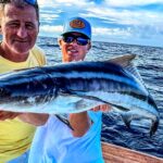
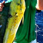
Primary Target (Offshore): Mahi-Mahi and Sailfish. The offshore bite has been excellent just 5 to 7 miles off the coast. The summer sailfish bite is heating up, and gaffer-sized dolphin are consistently being found under weed lines and frigate birds.
Sleeper Pick: Mangrove Snapper. Often overlooked by anglers chasing silver kings and linesiders, mangrove snapper move into the inshore estuaries and around bridge pilings in heavy numbers during the summer. They offer fantastic light-tackle action and are excellent table fare.
Baitfish Report: We are seeing a healthy flush of pass crabs moving through the causeways during the outgoing tides, which is ringing the dinner bell for tarpon. On the beaches and nearshore reefs, pilchards and threadfin herring are the dominant forage. Match your presentations to these bait sources for maximum success.
Tactical Strategy
Inshore & Nearshore (Snook and Tarpon)
Where: Focus your efforts on the St. Lucie Inlet and the Roosevelt Bridge in downtown Stuart. For wading anglers, the Jensen Beach Causeway offers consistent action along the grass flats and drop-offs.
Timing: Night tides and the first two hours of daylight are your highest percentage windows. Snook will push into deeper water during the heat of the day to stay cool, so target the 8-15 foot drop-offs with moving current if you are fishing midday.
Lures & Bait: For night fishing the shadow lines at the Roosevelt Bridge, throw a 1.5-ounce Flare Hawk jig in chartreuse and white. Work it slow and low against the bottom. For early morning topwater action on the flats, a Heddon Super Spook Jr. in bone or silver mullet will draw explosive strikes. If you prefer live bait, free-line live pilchards on a 4/0 inline circle hook with a 40-pound fluorocarbon leader for snook. For tarpon, drift live pass crabs on a 6/0 circle hook during the outgoing tide at the causeways.
Pro Tip: When targeting staging breeder snook around the inlet, upsize your tackle. Use a minimum of 40-pound braided main line and 60-pound fluorocarbon leader. The goal is to land these spawning fish quickly to minimize exhaustion and ensure a healthy release.
Offshore (Mahi-Mahi and Sailfish)
Where: Push north toward Fort Pierce and focus on the 150 to 200-foot depths. Look for temperature breaks, current rips, and sargassum weed lines.
Tactics: Trolling naked and skirted ballyhoo at 5 to 7 knots is the standard and highly effective approach. Keep a pitch bait ready (a live pilchard or threadfin on a spinning rod) for when schoolie Mahi rush the boat. The sailfish are aggressively taking live baits slow-trolled or kite-fished over the nearshore reefs.
Pro Tip: If you find a floating piece of debris or a dense weed patch holding Mahi, leave the first hooked fish in the water near the boat. The rest of the school will often stay close to their hooked companion, allowing your crew to pitch baits and double or triple up.
Regulations Snapshot
Florida's Fish and Wildlife Conservation Commission (FWC) heavily regulates these waters to protect spawning stocks. Always verify local rules, but here are the critical summer regulations for the Stuart area:
Species
Season Status
Key Regulations & Limits
Snook
CLOSED
Catch and Release ONLY during summer. Must use non-offset circle hooks when using natural bait. Handle with extreme care.
Tarpon
Open (Catch & Release)
Catch and Release ONLY. Fish over 40 inches MUST remain in the water at all times during release.
Mahi-Mahi (Dolphin)
Open
Minimum size limit is 20 inches fork length. Bag limit is 5 per harvester per day (Atlantic waters).
Mangrove Snapper
Open
Minimum size limit is 10 inches. Bag limit is 5 per harvester per day.
Regional Alternative
Palm City Spillway & The North Fork
If the coastal winds pick up or the St. Lucie Inlet is too rough to navigate safely, head inland to the Palm City Spillway or the North Fork of the St. Lucie River. These protected, brackish waters are a local favorite when coastal conditions deteriorate.
Tactical Approach: When water is actively flowing through the spillway, it creates an absolute feeding frenzy. You will find a unique mix of saltwater and freshwater species here, including snook, juvenile tarpon, jack crevalle, and largemouth bass. Throw a 1/2-ounce D.O.A. TerrorEyz in rootbeer/gold, bouncing it directly in the turbulent water of the spillway wash. Alternatively, pitching live shiners into the eddies will almost guarantee a mixed-bag catch. Access is easy from the shore, making it a perfect quick-strike mission if your boat plans get canceled.
Pro Tip: Pay attention to the water clarity in the North Fork. If recent heavy rains have muddied the water, switch your artificial lures to darker silhouettes (black or purple) to give the fish a better profile to strike against in the stained water.
Tight lines!
Editor's Choice: Must-Have Gear
FISHINGSIR Next-Gen Waterproof Chest Waders
★★★★★4.4 (7,370+ reviews)
2-Ply Tech: Upgraded nylon with 2.5x higher density than standard fabrics.
100% Waterproof: Lab-approved intrusion resistance with taped visible seams.
Ultra-Lightweight: Designed for all-day comfort while hunting or fishing.
As an Amazon Associate I earn from qualifying purchases. #ad
Loading forecast...
Live Fishing Conditions: Tides, Weather & Waves
Get real‑time tides, marine weather, swell and solunar activity for each spot so you know exactly when conditions line up for your best chance at a bite.
🎣
Stuart, FL
Loading coordinates...
🌤️
WEATHER CONDITIONS
--°F
--°C
Loading...
🌡️
Feels Like--°F--°C
💧
Humidity--%
💨
Wind-- mph-- km/h
🧭
Direction--
📊
Pressure-- inHg-- hPa
☀️
UV Index--
🌊
MARINE CONDITIONS
🌊Wave Height
-- ft
-- m
Loading...
🧭Wave Direction
--°
Loading...
⏱️Wave Period
-- s
Loading...
📈Tide Status
-- ft
-- m
Loading...
🌙
LUNAR & SOLUNAR
🌕
Loading...
Illumination: --%
Major Period--:-- - --:----:-- - --:--
Minor Period--:-- - --:----:-- - --:--
🌅Sunrise--:--
🌇Sunset--:--
📅
24-HOUR FORECAST
Loading fishing conditions...
Fishing Spots Map
🎣
Book a Fishing Charter near Stuart, FL Fishing Report Today 🎣
Local guides & charters. Verified captains, instant booking, best price guaranteed.
There was an error loading the map. Please try refreshing the page.
Info
Local Access & Facilities
Stuart, Florida, sits at a prestigious geographical convergence that few other fisheries can claim. Located where the extensive St. Lucie River system meets the biodiverse Indian River Lagoon, and just a short run from the Atlantic Ocean, this location serves as the eastern gateway to the Okeechobee Waterway. For the serious angler, this means a unique ability to target freshwater bass, brackish snook and tarpon, and pelagic sailfish all within a relatively tight radius. The topography here is defined by the transition from inland canal systems to the mangrove-lined estuaries that define the Treasure Coast.
The atmosphere is distinct from the high-pressure tourism of Miami or the remote isolation of the Keys. This is a working fishery with a heavy emphasis on navigation and boat handling, largely due to the lock systems and the active waterways. The water conditions vary drastically from the tannic, fresh outflows of the canal to the crystal-clear incoming tides at the inlet. The bottom topography is a mix of dredged channels, natural riverbeds, and the nearshore reef systems that make this area famous for its winter sailfish run.
Anglers targeting this area are typically looking for a "Grand Slam" potential. The primary draws are the massive Snook that patrol the bridges and spillways, particularly around the St. Lucie Lock, and the Tarpon that roll in the estuary during seasonal shifts. However, the logistical hub of Stuart also supports heavy offshore vessels looking to utilize the inlet for deep-water access. Understanding the interplay between the canal releases and the lagoon's health is often the key to unlocking the bite in this complex ecosystem.
Access & Getting There
Reaching the primary access points in Stuart typically involves navigating the I-95 corridor. For those towing larger vessels, taking Exit 101 (Stuart/Indiantown) and following SR 76 West is the most direct route to the inland facilities. This route avoids some of the downtown congestion and leads directly to Locks Road, a critical artery for anglers launching at the canal system. Traffic on Federal Highway (US 1) can be heavy during mid-morning and late afternoon, so early departures are essential to avoid delays between the highway and the ramp.
The boat launch situation here caters to a mix of vessel sizes. The St. Lucie South facility is the premier launch point for the canal system. It is located approximately 6.3 miles from the city center and offers a robust infrastructure managed by the Corps of Engineers. The ramps here are designed to handle the traffic of the Okeechobee Waterway, but skippers should be mindful of the current generated by the locks. Opening and closing schedules can dictate water movement, making loading and unloading challenging during peak flow. For those staying closer to the salt, there are unnamed public ramps near latitude 27.19, though parking capacity can be a limiting factor on weekends.
💡 Captain's Tip: Lock Operations
When launching or transiting near the St. Lucie Lock, pay close attention to the lock operators. Currents can change rapidly during chamber cycles. Furthermore, this area is a known hotspot for manatees; idle speeds are strictly enforced and propeller vigilance is mandatory to avoid fines and wildlife strikes.
Parking strategies vary significantly depending on your launch time. For anglers utilizing the downtown or urban access points, the One8 Parking lot on 256 S Colorado Ave is a strategic asset because it operates 24 hours a day. This allows for true "dawn patrol" starts or overnight trips without the fear of being towed or locked in. Public Parking at 401 S Colorado Ave is another viable option, rated highly for accessibility. For those meeting crew or consolidating vehicles, the Sailfish Circle P+R on SE Dixie Hwy provides a safe staging area before heading to the water.
Weather contingencies in Stuart are dictated by the trade winds and the lock schedules. When the Easterly trades blow over 15 knots, the Indian River Lagoon can develop a steep, uncomfortable chop, making the protected waters of the St. Lucie Canal a preferred fallback. The canal system offers significant wind protection due to the surrounding vegetation and leeward banks. Conversely, during periods of heavy rain, the canal discharge can dirty the water quickly; in these conditions, pushing closer to the Jupiter Inlet or the ocean-side beaches often yields cleaner water and better visibility for sight fishing.
Stuart, FL Pre-Trip Checklist
Facilities & Amenities
The infrastructure in Stuart is tailored to the serious boater, with a mix of high-end marine services and practical, working-class tackle shops. You won't find a generic approach here; the local businesses are highly specialized. For bait and terminal tackle, Snook Nook Discount Bait & Tackle in Jensen Beach is an institution. Opening at 6:00 AM, it is perfectly timed for anglers heading out for the morning bite. They are known for reliable live bait and specific local knowledge on snook movements.
For specialized gear, particularly for fly anglers or those targeting light-tackle species, 772 Fly and Light Tackle Charters (located on NW Sunset Blvd) serves a dual purpose as a resource hub. If your expedition requires heavy modification or custom rod work, Leffler Custom Rods in nearby Jupiter is the go-to artisan shop. They are located about 19 miles south but are worth the drive for expert repairs or custom builds suited to the heavy drag pressures of offshore fishing.
Facility Name
Type
Key Feature
Distance from Center
St. Lucie South
Campground/Marina
Cruiser Sites (Boat Camping) & 50 Amp Power
6.3 miles
Indiantown Marina
Marina
Inland Lake Okeechobee Access
18.4 miles
Snook Nook Bait & Tackle
Shop
Opens 6:00 AM Daily
3.9 miles
One8 Parking
Parking
Open 24 Hours
0.1 miles
A critical piece of "negative knowledge" for captains planning a trip here involves fuel and ice logistics. While St. Lucie South offers excellent camping and docking, it is primarily a campground and lock facility. Do not expect full-service marina amenities like a high-speed fuel dock or extensive ship store provisioning at the campground itself. It is advisable to fuel up the vessel and the truck at the stations along SR 76 or US 1 before committing to the launch ramp. Similarly, while Indiantown Marina supports the inland side, it is a significant distance (18+ miles) from the Stuart city center, so planning your fuel stops is essential.
Lodging logistics in Stuart offer a rare opportunity for boat-based accommodation. St. Lucie South Campground features dedicated "cruiser sites" specifically designed for boat campers. These slips come equipped with 50-amp electric and water hookups, allowing you to sleep aboard your vessel in a protected slip right on the waterway. This is a massive advantage for multi-day trips, eliminating the need to haul out and trailer to a hotel every night. For those preferring land-based stays, standard RV and tent sites are available, often with riverfront views.
💡 Captain's Tip: Provisioning
Most local tackle shops open early, but for heavy provisioning, hit the Truck Court/Loading Zone area at Treasure Coast Square if you are towing a large rig. It offers ample turning radius for boat trailers that standard grocery store lots cannot accommodate.
Permits, Regulations & Fees
Fishing in the Stuart area requires strict adherence to both state and federal regulations, managed primarily by the State Fishing Agency and federal partners. The importance of these rules cannot be overstated, as this region hosts critical habitats for protected species. The Nathaniel P. Reed Hobe Sound National Wildlife Refuge is a primary example. This area protects the largest contiguous section of undeveloped beach in Southeastern Florida and is a vital nesting ground for sea turtles. Anglers fishing the surf or nearshore waters here must be hyper-aware of nesting seasons and avoid disturbing marked dunes or nests.
The Jupiter Inlet Lighthouse Outstanding Natural Area (ONA) represents another layer of regulatory complexity. As part of the National Conservation Lands, this 120-acre site at the confluence of the Loxahatchee River and the Indian River Lagoon is protected for its historical and natural resources. While boating and fishing are popular, specific zones may restrict anchoring to protect seagrass beds and submerged archaeological sites. The "Kapu" or sacred nature of these historical lands should be respected; avoid trespassing on the lighthouse grounds or disturbing the shoreline vegetation.
Permitting for the St. Lucie South campground and boat slips is handled through the Recreation.gov system. Reservations are highly recommended, especially during the winter season when "snowbird" traffic peaks. The campground enforces strict rules regarding equipment; for instance, boat slips have width restrictions, and slip #8 or #1 are recommended for wider vessels. Failing to book the correct slip size can result in being turned away at the dock. Additionally, standard Florida saltwater and freshwater fishing licenses are required depending on which side of the lock you are casting in.
Events & Seasonal Information
The rhythm of the Stuart fishery is dictated by the seasons and the flow of water. Winter brings the renowned sailfish run offshore, attracting high-caliber sportfishing fleets to the local marinas. During this time, the boat ramps and channels leading to the St. Lucie Inlet can be congested with tournament traffic. Conversely, the summer months shift the focus to the inshore game, with Snook breeding seasons regulating where and how you can fish. The summer also brings the heavy rains, which can trigger lock releases from Lake Okeechobee, drastically changing the salinity and water color in the St. Lucie River.
The Hobe Sound National Wildlife Refuge dictates a different kind of seasonal rhythm. Sea turtle nesting season (typically March through October) may limit night fishing access on specific beaches. It is crucial to check the refuge's specific calendar before planning a surf fishing expedition during these months. For boaters, the manatee migration in winter concentrates these mammals near warm water discharges and lock systems, necessitating slow speeds and added travel time to your spots.
💡 Captain's Tip: Wind & Tides
The best bite in the estuary often correlates with the incoming tide pushing clean ocean water into the lagoon. However, if the trade winds pick up from the East against an outgoing tide at the inlet, the standing waves can be hazardous for smaller skiffs. Plan your inlet transits accordingly.
Contact Information & Resources
For official information regarding lock operations, camping reservations, and water conditions, the St. Lucie South facility can be reached directly at 772-287-1382. They are the authority on lock schedules and slip availability. For inquiries regarding the Nathaniel P. Reed Hobe Sound National Wildlife Refuge, including beach access and conservation rules, contact the refuge headquarters at 772-546-6141 or via email at HobeSound@fws.gov. The Jupiter Inlet Lighthouse ONA is managed by the Bureau of Land Management and can be reached at 601-331-7407.
Safety in this region requires self-reliance. While tow boat services are available, the transition zones between freshwater canals and open ocean can create communication dead zones or delayed response times. Always file a float plan, especially when transiting the locks or heading offshore. For precise locations, real-time wind conditions, and detailed bathymetry of the nearby spots, consult the live dashboard and interactive maps below.
Our spot reports combine data-driven forecasts with curated local information. The forecast is generated by our proprietary Fishing Score algorithm (0–100%), which analyzes real-time data from Open-Meteo API, validated against NOAA CO-OPS tide gauges and USGS water-monitoring stations. The model weights tide dynamics (35%), wave energy (25%), wind patterns (20%) and time of day (20%)—factors shown to influence fish feeding behavior through marine-biology research and decades of charter log data.
Access, facilities and services information for each fishing spot is sourced from official datasets such as Recreation.gov (RIDB), state park & wildlife agencies, and geospatial providers like Google Maps. These sections undergo scheduled re-validation every 3–6 months to ensure that boat ramps, park access, contact details and local services remain accurate.
Narrative sections (catches, seasonal behavior, local tips) are synthesized from these data sources and refined following the Fishing Reports Today editorial guidelines, combining bibliographic research from ichthyology and oceanography with expert angler experience. Our team reviews reports on a regular basis, while the forecast model itself updates every 6 hours for real-time accuracy.
⚠️ Important: Always verify current local regulations, access restrictions and weather conditions before fishing. These reports are intended as a planning aid, not a guarantee of catches or safety. When in doubt, contact local authorities or park managers listed on the page.
To provide the best experiences, we use technologies like cookies to store and/or access device information. Consenting to these technologies will allow us to process data such as browsing behavior or unique IDs on this site. Not consenting or withdrawing consent, may adversely affect certain features and functions.
Functional Always active
The technical storage or access is strictly necessary for the legitimate purpose of enabling the use of a specific service explicitly requested by the subscriber or user, or for the sole purpose of carrying out the transmission of a communication over an electronic communications network.
Preferences
The technical storage or access is necessary for the legitimate purpose of storing preferences that are not requested by the subscriber or user.
Statistics
The technical storage or access that is used exclusively for statistical purposes.The technical storage or access that is used exclusively for anonymous statistical purposes. Without a subpoena, voluntary compliance on the part of your Internet Service Provider, or additional records from a third party, information stored or retrieved for this purpose alone cannot usually be used to identify you.
Marketing & Affiliates
The technical storage or access is required to create user profiles to send advertising, or to track the user on a website or across several websites for similar marketing purposes, including affiliate tracking for products recommended in our reports.


Leave a Reply