Mazurik Boat Ramp & Lake Erie Western Basin Fishing Report
As a Senior Fishing Editor and a Pro Guide who spends countless days launching out of the Mazurik Boat Ramp on the Marblehead Peninsula, I can tell you that spring on Lake Erie is nothing short of legendary. We are currently sitting on one of the most robust fisheries on the planet. The post-spawn feed is in full swing, and the fish are aggressively putting on weight. Whether you are a seasoned tournament angler or a weekend warrior, here is your comprehensive, tactical breakdown for maximizing your time on the water out of Mazurik.
1. GO/NO-GO STATUS
Verdict: GO - WITH WIND CAUTION
Safety Advisory: Spring on Lake Erie demands the utmost respect from every angler. Current water temperatures are hovering in the upper 40s to low 50s (approximately 51 degrees off Toledo and cooling slightly as you push further east). At these frigid temperatures, hypothermia is a rapid and severe threat if you go overboard. Wearing a well-fitted, Coast Guard-approved PFD is mandatory, and keeping a set of dry clothes in a waterproof bag is highly recommended.
From the editor
Tired of fishing with strangers you can’t trust?
Nautrek is the first social network for serious anglers — verified partners, real trips, cost splitting and intel sharing without burning your spots. Private beta now open.
Weather Impact: Spring weather is notoriously volatile. While the Mazurik access provides a fantastic, protected boat bay and safe harbor, the open lake is a different animal entirely. Winds blowing out of the North or Northeast will stack up dangerous, tightly spaced waves in the shallow Western Basin. Always check the marine forecast before leaving the dock. If the winds are light or blowing moderately from the South or Southwest, you have a green light for world-class fishing.
2. SPECIES INTEL
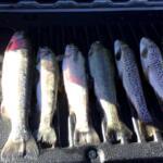
Primary Target: Walleye Lake Erie is rightfully crowned the Walleye Capital of the World, and the current population estimates are staggering—hovering between 58 and 80 million fish. The post-spawn feed is highly active right now. Anglers are seeing incredible numbers of 17 to 22-inch "eater" class fish, mixed heavily with genuine 25-inch-plus trophies migrating back from their shallow spawning grounds.
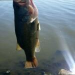
Sleeper Pick: Smallmouth Bass While the armada of boats is entirely focused on walleye, the smallmouth bass fishing around the rocky shorelines of Kelleys Island and South Bass Island (Put-in-Bay) is phenomenal. These giant bronzebacks are pulling up to their shallow spawning grounds. A 5-pound smallmouth is common here, making it a world-class sleeper target for those willing to cast the nearshore rock piles.
Baitfish Report: Emerald shiners and gizzard shad are the primary forage driving the food web. With the water still carrying a bit of spring stain from recent rains and river runoff, matching the hatch means using lures with strong profiles and high-contrast colors to mimic distressed baitfish in choppy water.
3. TACTICAL STRATEGY
To maximize your time on the water, you need to approach the Western and Central Basin transition zones with a specific game plan. Here is exactly how we are putting fish in the boat this week.
Where to Fish
From the Mazurik four-lane concrete ramps, you have prime access to the best structure on the lake. For the trollers, make the run north of the Western Basin reef complex and focus on the 22 to 26-foot depth contours. Another highly productive zone is east of Kelleys Island in 40 to 45 feet of water. If you prefer casting and jigging, focus on the 10 to 16-foot water near Turtle Creek, Mouse Island Reef, or the shallow rock piles off Kelleys Island Shoal.
Lure Selection & Color
Trolling: Deep-diving jerkbaits are producing easy limits. Run unassisted deep-diving crankbaits (such as Bandit Deep Walleyes or Rapala Husky Jerks) or run them assisted with 2-ounce inline snap weights to get your lures down to the 15 to 20-foot strike zone. Deploy your crankbaits on inline planer boards to spread your lines and avoid spooking fish with the boat hull. Speed is critical; dial your trolling motors in at 1.8 to 2.0 mph.
Casting: A 5/8-ounce or 3/4-ounce hair jig is the ticket. In Lake Erie's slightly stained spring water, you cannot go wrong with purple, chartreuse, and pink. "Purple Hair Jigs" rigged with a stinger hook are a local religion. For crankbaits, custom colors like "Pink Lemonade," "Blue Chrome," or anything with a bright chartreuse belly will trigger aggressive reaction strikes.
Bait & Rigging
If the jig bite gets tough, tip your hair jigs or lead-head jigs with a lively emerald shiner. Hook the shiner through the lips to keep it swimming naturally. The added scent and flash will often turn curious lookers into aggressive biters, especially on bluebird sky days when the fish press tight to the bottom. Fluorocarbon leaders (12 to 15-pound test) are highly recommended to remain invisible to heavily pressured walleye.
Timing the Bite
The dawn patrol is absolutely critical for the shallow casting bite on the reefs. As the sun rises and penetrates the water column, the walleye will slide deeper to protect their sensitive eyes. By mid-morning, transition from casting the 10-foot rock piles to trolling the 25-foot mud flats.
Pro Tip: When vertical jigging the reefs, keep your jig no more than 6 to 12 inches off the bottom. Lake Erie walleye will often pin the bait to the rocks, and lifting it too high pulls it right out of their strike window. Short, sharp snaps followed by a controlled fall will get the job done.
Pro Tip: Mazurik is a high-traffic access point featuring a state-of-the-art fish cleaning station. When utilizing the station after a successful trip, remember it is for fish waste only. Do not overload the grinder, and be courteous by utilizing the designated parking spots rather than blocking the "make ready" boat lanes!
4. REGULATIONS SNAPSHOT
Before you launch, ensure you are fully compliant with Ohio Department of Natural Resources (ODNR) regulations for the Lake Erie Zone. Here is your current cheat sheet:
Species
Minimum Size
Daily Bag Limit
Season Notes
Walleye
15 inches
6 fish
Open year-round
Black Bass (Largemouth & Smallmouth)
18 inches
1 fish
May 1 - June 26 (Strict conservation limit)
Yellow Perch
No minimum
30 fish
West Zone specific limit
White Bass
No minimum
No limit
Open year-round
5. REGIONAL ALTERNATIVE
If you arrive at Marblehead and Lake Erie is churning with 4 to 6-foot rollers from a nasty North wind, do not risk your life or your vessel. Your best backup plan is to trailer the boat 20 minutes south to Sandusky Bay. Launch at the Dempsey Fishing Access.
Sandusky Bay offers significant geographical protection from northern blows and is an absolute hotspot for aggressive White Bass and massive Channel Catfish during the spring months. Anchor up near the bay bridges or deeper channel swings and soak cut bait (gizzard shad or raw shrimp) on a slip-sinker rig on the bottom for channel cats. For white bass, cast 1/4-ounce silver inline spinners or small white twister-tail grubs along the shorelines and current seams. The action is often non-stop, easily saving what would otherwise be a blown-out day on the big water.
Tight lines!
Editor's Choice: Must-Have Gear
FISHINGSIR Next-Gen Waterproof Chest Waders
★★★★★4.4 (7,370+ reviews)
2-Ply Tech: Upgraded nylon with 2.5x higher density than standard fabrics.
100% Waterproof: Lab-approved intrusion resistance with taped visible seams.
Ultra-Lightweight: Designed for all-day comfort while hunting or fishing.
As an Amazon Associate I earn from qualifying purchases. #ad
Loading forecast...
Live Fishing Conditions: Tides, Weather & Waves
Get real‑time tides, marine weather, swell and solunar activity for each spot so you know exactly when conditions line up for your best chance at a bite.
🎣
Mazurick Boat Ramp
Loading coordinates...
🌤️
WEATHER CONDITIONS
--°F
--°C
Loading...
🌡️
Feels Like--°F--°C
💧
Humidity--%
💨
Wind-- mph-- km/h
🧭
Direction--
📊
Pressure-- inHg-- hPa
☀️
UV Index--
🌊
MARINE CONDITIONS
🌊Wave Height
-- ft
-- m
Loading...
🧭Wave Direction
--°
Loading...
⏱️Wave Period
-- s
Loading...
📈Tide Status
-- ft
-- m
Loading...
🌙
LUNAR & SOLUNAR
🌕
Loading...
Illumination: --%
Major Period--:-- - --:----:-- - --:--
Minor Period--:-- - --:----:-- - --:--
🌅Sunrise--:--
🌇Sunset--:--
📅
24-HOUR FORECAST
Loading fishing conditions...
Fishing Spots Map
🎣
Book a Fishing Charter near Mazurick Boat Ramp Fishing Report Today 🎣
Local guides & charters. Verified captains, instant booking, best price guaranteed.
There was an error loading the map. Please try refreshing the page.
Info
Local Access & Facilities
The high-country fishery surrounding the Mazurick Boat Ramp in Forest Lakes, Arizona, offers a distinct experience for anglers seeking solitude among the ponderosa pines. Situated within the Apache-Sitgreaves National Forests, this location serves as a gateway to the cool, productive waters characteristic of the Mogollon Rim region. Unlike the bustling, manicured marinas found in lower elevations, this spot retains a rugged, alpine atmosphere where the air is thin and the water is crisp. The environment here is defined by red dirt trails, towering timber, and a quiet intensity that appeals to serious freshwater enthusiasts.
For the seasoned captain or dedicated shore angler, this area represents a logistical shift from urban fishing. The infrastructure is designed for self-reliance, catering to those who are comfortable hauling their own gear and navigating forest service roads. While the name might suggest a massive concrete facility, the reality on the ground in Forest Lakes is more understated and integrated with the natural landscape. The primary draw here is the access it provides to high-elevation waters where game fish thrive in cooler temperatures, offering a reprieve from the desert heat below.
Understanding the lay of the land is critical before hitching up the trailer. The area is a mix of developed recreation zones and raw forest access, requiring a strategic approach to vehicle staging and launch timing. Whether you are targeting trout in the nearby lakes or exploring the creek systems, success at this location often comes down to preparation and understanding the nuances of the local forest roads. The following guide breaks down the essential logistics to ensure your trip to the high country is efficient and productive.
Access & Getting There
Reaching the access points around Forest Lakes generally involves travel along the primary artery of AZ-260, a scenic but winding highway that demands attention, especially when towing heavy loads. The transition from the highway to the water often requires navigating secondary routes such as Forest Road 237. Experienced drivers know that traffic on the 260 can swell significantly on weekends, particularly with campers and RVs escaping the valley heat. To maximize fishing time, plan your arrival to avoid the mid-morning congestion that often clogs the turnoffs near the rim.
The launch situation in this region is functional but varies by specific water body. The data indicates the presence of multiple boat ramps within a short radius, with the nearest being approximately 3.7 miles from the central hub, and others at 6.6 and 7.4 miles out. These are typically Forest Service style ramps—often concrete but sometimes transitioning to gravel or natural bottom depending on water levels. For those hauling larger aluminum fishing boats or fiberglass rigs, it is prudent to inspect the ramp condition before backing down, as seasonal fluctuations in water depth can alter the traction and angle of the launch significantly.
💡 Captain's Tip: Staging Strategy
If you are towing a larger rig or meeting a group, utilize the 237 B Trailhead just past mile post 1 off Forest Road 237. It offers a solid staging location with better turning radius than some of the tighter water-side access points.
Weather in this high-altitude corridor is the primary variable for access. Summer monsoons can turn hard-packed dirt roads into slick mud in minutes, potentially complicating the drive out if you are towing with a 2WD vehicle. When the afternoon thunderheads build over the Rim, wind shear can whip up significant chop on the water and make trailering difficult. The smart play is to launch early and be prepared to haul out by early afternoon if the sky turns dark. Parking is generally available, with specific designated areas like the Horton Springs Parking Lot, though this is a considerable distance (over 15 miles) from the immediate fishing grounds, serving more as an overflow or hiking base.
Mazurick Boat Ramp Pre-Trip Checklist
Facilities & Amenities
The infrastructure around Forest Lakes is purpose-built for the outdoor recreationist rather than the luxury tourist. For immediate tackle and provisions, Gilligan's Forest Lakes General Store is the local lifeline. Located roughly 2 miles from the core access area on AZ-260, this shop is essential for last-minute bait, ice, and basic gear repairs. However, anglers planning a "dawn patrol" launch should note that the store opens at 7:00 AM. If you intend to have lines in the water at first light, you must secure your bait and supplies the evening before.
Accommodations in the immediate vicinity are dominated by RV parks and campgrounds, reflecting the mobile nature of the angler base here. Five Lakes RV Park is the most convenient commercial option, situated less than 3 miles away, making it an excellent base camp for multi-day excursions. For a more immersive nature experience, the Fr 171 Campground on Old Rim Rd puts you roughly 4.5 miles from the action. These facilities are generally well-maintained, but they fill up rapidly during the peak season. The table below outlines the primary lodging logistics for planning your stay.
Facility Name
Distance
Type
Notes
Five Lakes RV Park
2.9 miles
RV Park
Closest commercial lodging; high user rating.
Fr 171 Campground
4.5 miles
Campground
Located on Old Rim Rd; rustic forest setting.
Boulders RV Park
13.9 miles
RV Park
Located in Heber; reliable overflow option.
Mountain Retreat RV Park
16.9 miles
RV Park
Open 24 hours; good for late arrivals.
It is important to note what is not available at the water's edge. While the data indicates the presence of restrooms (Public Restroom 1 and 2, and R502) within a 1.8-mile radius, do not expect full-service marinas with fuel docks or mechanic services. You must fuel your vessel on the highway before entering the forest road network. Additionally, while the Al Fulton Point Picnic Area offers family-friendly shore access and amenities roughly 5 miles out, specialized fish cleaning stations are not guaranteed at every ramp, so bringing a cooler dedicated to transport is a wise move.
💡 Captain's Tip: Fuel Logistics
There are no fuel docks on the water. Top off your boat and tow vehicle at the stations in Heber-Overgaard or Payson before committing to the forest roads, as consumption increases with the elevation climb.
Permits, Regulations & Fees
Fishing activities in this sector fall under the jurisdiction of the State Fishing Agency. While the specific data indicates no special "permit_required" flags beyond the standard state license, strict adherence to statewide regulations is mandatory. This area is heavily patrolled due to its popularity and the sensitivity of the high-country ecosystem. Anglers should be intimately familiar with bag limits for trout and other game fish, as these can vary seasonally or by specific body of water within the national forest.
Beyond the legal requirements, there is a cultural and environmental imperative to respect the land. The Apache-Sitgreaves National Forests contain areas of historical and cultural significance. The concept of stewardship here is paramount; "pack it in, pack it out" is not just a suggestion, it is the rule. The use of the 237 B Trailhead and other staging areas relies on users keeping them clean. Discarded line and bait containers are major threats to local wildlife. Furthermore, while the area is listed as wheelchair accessible, visitors should verify the current status of specific shoreline access points like Al Fulton Point to ensure they meet immediate needs.
Events & Seasonal Information
The rhythm of the fishery here is dictated entirely by the seasons. The high elevation means that winter conditions can persist well into spring, with Forest Road 237 and other access routes potentially subject to seasonal closures due to snowpack or mud. The prime window for easy access typically opens in late spring and extends through early autumn. During the peak summer months, the area sees increased pressure, not just from anglers but from hikers utilizing the Larson Ridge Trailhead and Canyon Dr Access.
Timing your day is crucial. The wind patterns on the Rim are predictable; calm mornings often give way to gusty afternoons. Experienced locals know to hit the water immediately at sunrise to capitalize on the glass-calm conditions and active feeding windows. If you are shore fishing at spots like Al Fulton Point, the early morning hours also provide the best opportunity to secure a prime spot before the recreational crowds arrive. There are no major tournament circuits explicitly listed for this specific ramp in the data, suggesting this is a location favored more by recreational experts than competitive fleets.
💡 Captain's Tip: Wind Warning
Trade winds and thermal breezes kick up reliably by 10:00 AM. If you are in a small craft or kayak, plan your drift to end near the launch by mid-morning to avoid fighting a stiff headwind on the return leg.
Contact Information & Resources
For the most current information regarding road closures, fire restrictions, and facility status, the primary authority is the Forest Service. They manage the Apache-Sitgreaves National Forests and the associated recreation areas. In the event of an emergency, cell service can be spotty in the deep timber and canyons, so carrying a satellite messenger or having a clear travel plan filed with someone on shore is recommended. Self-reliance is key in this environment.
For precise locations, real-time weather updates, and detailed topography of the boat ramps and shore entry points mentioned, consult the live dashboard and interactive maps below.
Our spot reports combine data-driven forecasts with curated local information. The forecast is generated by our proprietary Fishing Score algorithm (0–100%), which analyzes real-time data from Open-Meteo API, validated against NOAA CO-OPS tide gauges and USGS water-monitoring stations. The model weights tide dynamics (35%), wave energy (25%), wind patterns (20%) and time of day (20%)—factors shown to influence fish feeding behavior through marine-biology research and decades of charter log data.
Access, facilities and services information for each fishing spot is sourced from official datasets such as Recreation.gov (RIDB), state park & wildlife agencies, and geospatial providers like Google Maps. These sections undergo scheduled re-validation every 3–6 months to ensure that boat ramps, park access, contact details and local services remain accurate.
Narrative sections (catches, seasonal behavior, local tips) are synthesized from these data sources and refined following the Fishing Reports Today editorial guidelines, combining bibliographic research from ichthyology and oceanography with expert angler experience. Our team reviews reports on a regular basis, while the forecast model itself updates every 6 hours for real-time accuracy.
⚠️ Important: Always verify current local regulations, access restrictions and weather conditions before fishing. These reports are intended as a planning aid, not a guarantee of catches or safety. When in doubt, contact local authorities or park managers listed on the page.
To provide the best experiences, we use technologies like cookies to store and/or access device information. Consenting to these technologies will allow us to process data such as browsing behavior or unique IDs on this site. Not consenting or withdrawing consent, may adversely affect certain features and functions.
Functional Always active
The technical storage or access is strictly necessary for the legitimate purpose of enabling the use of a specific service explicitly requested by the subscriber or user, or for the sole purpose of carrying out the transmission of a communication over an electronic communications network.
Preferences
The technical storage or access is necessary for the legitimate purpose of storing preferences that are not requested by the subscriber or user.
Statistics
The technical storage or access that is used exclusively for statistical purposes.The technical storage or access that is used exclusively for anonymous statistical purposes. Without a subpoena, voluntary compliance on the part of your Internet Service Provider, or additional records from a third party, information stored or retrieved for this purpose alone cannot usually be used to identify you.
Marketing & Affiliates
The technical storage or access is required to create user profiles to send advertising, or to track the user on a website or across several websites for similar marketing purposes, including affiliate tracking for products recommended in our reports.


Leave a Reply