Lake Superior North Shore, Minnesota Fishing Report Today 🎣
9 months ago · Updated 5 days ago

GO/NO-GO STATUS
Verdict: GO
Summer conditions have firmly stabilized across the North Shore, opening up prime fishing windows for both small boat anglers and offshore trolling vessels. The weather patterns are currently highly favorable for nearshore casting and deep-water trolling. However, you must always respect the Big Lake. While inland temperatures are soaring, Lake Superior's surface temperatures often hover in the mid-40s to low-50s offshore. A sudden east wind can push fog banks in rapidly, building dangerous swells and dropping ambient temperatures by twenty degrees in a matter of minutes. Always pack heavy cold-weather gear, monitor marine band VHF weather channels constantly, and ensure your vessel is equipped with up-to-date safety equipment. For shore anglers, conditions are phenomenal, but use extreme caution on wet basalt rocks near the splash zone, as rogue waves are a constant threat.
SPECIES INTEL
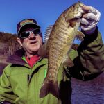
Primary Target: Lake Trout
Lake Trout are the undisputed kings of the North Shore right now. Recent fisheries surveys indicate a record-high abundance of these native predators. Thanks to a highly successful year-class of cisco (lake herring) pushing through the system, the lake trout are exceptionally well-fed, heavy-shouldered, and highly aggressive. Rather than strictly hugging the bottom structure, you will find active pods of lakers suspended in the middle of the water column, actively hunting bait schools.

Sleeper Pick: Coho, Chinook, and Pink Salmon
While many anglers hyper-focus on the lake trout bite, the pelagic salmon bite is explosive and often overlooked by bottom-bouncers. The same cisco boom feeding the lakers has allowed non-native salmonids to reach staggering proportions this season. If you are willing to dedicate your spread to the upper third of the water column, you have a legitimate shot at double-digit Coho and massive Chinook salmon cruising the thermal breaks. Additionally, moderate numbers of Pink Salmon are currently being caught in the top 60 feet of the water column, providing excellent light-tackle action.
Baitfish Report
The forage base is currently dominated by massive schools of cisco and rainbow smelt. These bait balls are dense, highly mobile, and dictate predator movements. When selecting your presentation, mimic the elongated, silver-sided profile of a cisco or the slender, iridescent flash of a smelt. Because the baitfish have matured, do not be afraid to upsize your lures to match the larger forage currently present in the system.
TACTICAL STRATEGY
Where to Deploy
For boat anglers working the Upper Shore (Twin Points up through Grand Marais and Hovland), focus your efforts on the 60 to 120-foot depth contours. Look for suspended fish holding around the 60-foot mark over much deeper water. The offshore humps near Silver Bay and Taconite Harbor are currently holding massive concentrations of bait.
For shore-bound anglers, the Two Harbors Breakwall and the deep-water access near McQuade Harbor are your best bets. The long reach of the Two Harbors breakwall gives you access to the deep, cold water that cruising salmon and trout utilize to trap baitfish against the structure. The mouth of the Lester River is also worth a look for cruising fish pushing into the warmer plume.
Pro Tip: Keep a close eye on your marine electronics. If you mark thick bait balls but aren't getting bit, immediately change your trolling speed or direction. A sudden acceleration or a sharp "S" turn will cause your spoons to flutter unpredictably or stall, often triggering a trailing, hesitant lake trout to strike out of pure reflex.
Lure Selection and Gear
If you are trolling, large spoon patterns are dominating the bite. Run 4-inch to 5-inch trolling spoons to match the cisco profile. If you are casting from shore, aerodynamic, heavy hardware is essential to punch through the coastal wind and achieve maximum distance. A 3/4-ounce Krocodile spoon or a 2/3-ounce Little Cleo are mandatory in your surf bag. Pair these with a 9 to 11-foot medium-heavy spinning rod spooled with 20-pound braided line and a 12-pound fluorocarbon leader for maximum casting distance and invisibility in the gin-clear water.
Color Patterns
Lake Superior's water clarity is exceptional right now. For sunny, high-sky conditions, rely on natural metallic finishes: silver/blue and silver/green are highly effective. However, recent reports show that purple and green combinations (often called "UV Green Dolphin" or "Purple Haze") are triggering aggressive reaction strikes from suspended lake trout, especially when fished off downriggers down deep where light penetration shifts and UV colors excel.
Bait and Rigging
For trolling, run a multi-level mixed spread to cover the water column. Deploy downriggers targeting the 50-70 foot depths for lake trout, while running lead core lines (5 to 7 colors) or Dipsy Divers higher in the column for roaming salmon. Run your spoons clean, or utilize an 8-inch silver flasher paired with a blue/green trolling fly for a larger, noisier profile.
Pro Tip: When shore casting the breakwalls, swap out the factory treble hooks on your spoons for a single 1/0 or 2/0 Siwash hook. Not only does this comply with tributary and nearshore regulations in many restricted zones, but it also results in a much higher landing percentage when battling acrobatic salmon, and snags significantly less on the jagged rocky bottom.
Timing the Bite
While the classic dawn patrol is always effective, the late afternoon and evening bite has been significantly outperforming the morning window lately. Anglers fishing the last three hours of daylight are capitalizing on baitfish pushing higher in the water column as the sun angle drops. If you are shore casting, the twilight window into the first hour of complete darkness is prime time for big fish pushing shallow.
REGULATIONS SNAPSHOT
The Minnesota Department of Natural Resources has implemented several crucial updates for the 2026 season that directly impact North Shore anglers. It is your responsibility to know these before hitting the water:
- Salmon Limits: The previous restriction limiting anglers to only one Atlantic Salmon has been completely removed. The new regulation allows for a five (5) combined total for all salmon species (Chinook, Coho, Pink, Atlantic).
- Lake Trout: The possession limit remains three (3) fish.
- Tackle Restrictions: New statewide rules allow up to three hooks within 18 inches on a single tackle configuration. However, only one bait is allowed per line, and stinger hooks are only permitted on artificial baits.
- Tributary Boundaries: Below posted boundaries on Lake Superior tributaries, anglers are strictly restricted to a single hook or fly (absolutely no treble hooks allowed).
Pro Tip: Always double-check the posted boundary signs on specific rivers like the Lester, French, or Knife rivers. Regulations, including hook types and open seasons, shift dramatically the moment you step upstream of the designated markers. Ignorance of the boundary line is not an excuse for a citation.
REGIONAL ALTERNATIVE
Superior National Forest Inland Lakes
If an angry east wind whips Lake Superior into a frenzy of six-foot rollers, do not pack up and go home. The inland lakes of the Superior National Forest, easily accessible via the Gunflint Trail out of Grand Marais or Highway 1 out of Finland, offer world-class, sheltered alternatives.
Target Species: Walleye, Smallmouth Bass, and Inland Lake Trout.
Tactical Approach: The inland waters warm up much faster than the Big Lake, putting fish into their stable summer patterns. Smallmouth bass have wrapped up their spawn and are aggressively feeding on rocky points and submerged boulder transitions in 8 to 15 feet of water. Throw a 1/8-ounce tungsten jig paired with a 3-inch green pumpkin tube bait, or work a suspending jerkbait aggressively over the rock piles. For walleye, target the deep weed edges or mid-lake humps during the low-light hours using a slip bobber rig tipped with a lively leech or a crawler harness. The inland lakes provide sheltered, glass-calm waters surrounded by towering pines when Superior is unfishable, saving your trip and filling the cooler with premium fillets.
Tight lines!

FISHINGSIR Next-Gen Waterproof Chest Waders
- 2-Ply Tech: Upgraded nylon with 2.5x higher density than standard fabrics.
- 100% Waterproof: Lab-approved intrusion resistance with taped visible seams.
- Ultra-Lightweight: Designed for all-day comfort while hunting or fishing.
✓ Amazon's Choice | 100+ bought last month
Bandit Walleye Deep
Mandatory for reaching deep schools in 35-50ft mud flats.
Check Price on Amazon #adAs an Amazon Associate I earn from qualifying purchases. #ad
Live Fishing Conditions: Tides, Weather & Waves
Get real‑time tides, marine weather, swell and solunar activity for each spot so you know exactly when conditions line up for your best chance at a bite.
Lake Superior North Shore, Minnesota
Loading coordinates...
WEATHER CONDITIONS
Loading...
MARINE CONDITIONS
LUNAR & SOLUNAR
Loading...
Illumination: --%
24-HOUR FORECAST
Fishing Spots Map
Local guides & charters. Verified captains, instant booking, best price guaranteed.
Local Access & Facilities
Lake Superior North Shore, Minnesota
Parking
Bait & Tackle
Fishing Charters
Lodging
Boat Ramps
Restrooms
Family Friendly
Accessibility
Wheelchair Access
Available
Pets Allowed
Not Confirmed
⚠️ Some accessibility info not officially confirmed. Please verify with location directly.
Local guides & charters. Verified captains, instant booking, best price guaranteed.
Nearby Spots


About Our Fishing Reports & Forecasts
Our spot reports combine data-driven forecasts with curated local information. The forecast is generated by our proprietary Fishing Score algorithm (0–100%), which analyzes real-time data from Open-Meteo API, validated against NOAA CO-OPS tide gauges and USGS water-monitoring stations. The model weights tide dynamics (35%), wave energy (25%), wind patterns (20%) and time of day (20%)—factors shown to influence fish feeding behavior through marine-biology research and decades of charter log data.
Access, facilities and services information for each fishing spot is sourced from official datasets such as Recreation.gov (RIDB), state park & wildlife agencies, and geospatial providers like Google Maps. These sections undergo scheduled re-validation every 3–6 months to ensure that boat ramps, park access, contact details and local services remain accurate.
Narrative sections (catches, seasonal behavior, local tips) are synthesized from these data sources and refined following the Fishing Reports Today editorial guidelines, combining bibliographic research from ichthyology and oceanography with expert angler experience. Our team reviews reports on a regular basis, while the forecast model itself updates every 6 hours for real-time accuracy.
⚠️ Important: Always verify current local regulations, access restrictions and weather conditions before fishing. These reports are intended as a planning aid, not a guarantee of catches or safety. When in doubt, contact local authorities or park managers listed on the page.
Leave a Reply