Key Largo Summer Transition: The Definitive Angler's Briefing
The seasonal shift is officially complete across the Upper Keys, and the legendary summer pattern has taken hold. As a Senior Fishing Editor and Key Largo guide, I can confidently report that the relentless spring winds have finally laid down, giving way to the slick-calm, glassy mornings that offshore anglers dream about. The water temperatures are steadily climbing, the Gulf Stream is pushing rich, blue water close to the reef tract, and the pelagic migration is in full swing. Whether you are hunting the deep-water blue rips or stalking the shallow backcountry flats, the ecosystem is incredibly active right now.
GO/NO-GO STATUS
Verdict: GO - WITH SQUALL CAUTION
Current seasonal conditions dictate a definitive "GO" for all vessels, but it comes with a strict safety advisory regarding the summer weather pattern. The morning hours offer spectacular, mirror-like conditions, making it safe for even smaller center consoles to push out past the reef. However, the extreme midday heat index causes massive thermal thunderstorms to build over the mainland Everglades. By mid-to-late afternoon, these severe squalls predictably march eastward across Florida Bay and into the Atlantic.
🎣Nautrek
Private Beta
J
M
R
100+ anglers on the waitlist
The fishing network where your reputation matters.
Find trusted captains, join real trips with cost splitting, and build your Angler Rank. Your spots stay private — you decide who sees your intel.
Weather Impact Assessment: Plan your trips around a "dawn patrol" schedule. Leaving the dock before sunrise not only ensures you capitalize on the most aggressive low-light feeding windows, but it also allows you to be safely back at the marina or tucked into a protected sound before the afternoon lightning and high winds arrive. Hydration and heavy sun protection are non-negotiable right now.
SPECIES INTEL
The summer biomass in Key Largo is incredibly diverse, offering distinct targets depending on which side of the Overseas Highway you choose to fish.
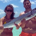
Offshore, the "Slammer" Mahi-Mahi are running in force. These heavy bulls and cows are congregating along deep-water temperature breaks and floating sargassum weedlines. On the Atlantic reef tract, the Mutton Snapper are gathering for their annual summer spawning aggregations around the full moon phases, offering some of the most explosive, drag-screaming bottom action of the entire year.
Sleeper Pick: Shallow-Water Patch Reef Muttons
While the majority of the fleet burns expensive fuel running to the 200-foot drop-offs to deep-drop, elite local guides are exploiting a highly productive, lesser-known pattern: giant Mutton Snappers holding on shallow patch reefs in Hawk Channel. In just 10 to 15 feet of water, these brutes are actively feeding on the sand edges of coral heads. This provides an incredible light-tackle challenge that most visiting anglers completely overlook in their rush to reach the Gulf Stream.
Baitfish Report
The offshore pelagic bite is currently being driven by massive schools of flying fish and migrating ballyhoo. Inshore, and particularly around the patch reefs and backcountry mangrove shorelines, thick pods of pilchards (scaled sardines) and pinfish have moved in. Matching your bait profile to these specific forage species is the key to triggering strikes from pressured fish.
TACTICAL STRATEGY
Offshore Pelagic Hunt
Where: Bypass the scattered, nearshore "schoolie" dolphins and push out to the 600 to 800-foot depths. Utilize your bathymetry charts to locate high-profile underwater structures, such as the Duane Wreck off Key Largo. These massive structures create deep-water upwellings—deflecting cold, nutrient-rich currents toward the surface. This traps plankton, which draws the baitfish, which in turn brings the Slammer Mahi and Wahoo.
Lure & Bait: Troll skirted, wire-rigged ballyhoo on 8/0 inline circle hooks. In the ultra-clear summer Gulf Stream water, Blue/White and Pink/White Islander skirts are vastly outperforming darker colors. Keep a heavy pitch rod rigged with a naked, chunked ballyhoo on a 5/0 circle hook sitting in the leaning post, ready for immediate deployment.
Timing: The first two hours of daylight are critical. Pelagics use the low-angle morning sun to ambush prey silhouetted against the surface.
Pro Tip: When you hook a large Mahi, do not immediately boat it. Leave the hooked fish swimming in the water ten feet behind the transom. Mahi are highly competitive schooling fish; the rest of the pack will follow their hooked counterpart right up to the boat, allowing your crew to pick them off one by one with pitch baits.
Patch Reef & Backcountry Tactics
Where: For the shallow Mutton Snapper, target the geological formations of Hawk Channel. Look for steep, small depth gradients on your sonar where the sand meets coral rubble. For backcountry Snook, navigate to the mangrove-lined channels along the Everglades National Park boundary, specifically working the current seams near Largo Sound and Garden Cove.
Lure & Bait: To fool line-shy Muttons in 12 feet of crystal-clear water, you must downsize your terminal tackle. Use an excessively long, 30 to 40-foot fluorocarbon leader (40lb test) tied to a 3/0 circle hook, pinning a frisky live pinfish near the bottom. For backcountry Snook, cast a 1/4oz tungsten jig head paired with a 4-inch white paddletail directly into the shaded mangrove roots.
Timing: Tidal movement is absolute. Fish the last two hours of the incoming tide and the first hour of the outgoing. Stagnant water equals a dead bite.
Pro Tip: When fishing the Hawk Channel patch reefs, your success relies entirely on your chum slick. Purchase high-quality, fine-mesh chum blocks from local suppliers and deploy them continuously. A heavy, unbroken chum slick will draw big Snapper and Grouper completely out of their rocky crevices and right up to the surface behind your vessel.
REGULATIONS SNAPSHOT
Monroe County and the Florida Fish and Wildlife Conservation Commission (FWC) strictly enforce regional management zones. Always verify current vessel limits prior to departure, but adhere to these critical summer guidelines:
Species
Current Status
Key Tactical Regulations
Snook
CLOSED for Harvest
Strictly catch-and-release only during the summer months to protect vital spawning populations. Handle with wet hands and release quickly.
Mahi-Mahi (Dolphin)
OPEN
Strict minimum size limits apply. Be aware of both individual daily bag limits and maximum vessel limits, which are heavily monitored at the docks.
Atlantic Grouper
OPEN
The Atlantic season is open. Non-offset circle hooks are legally required when fishing with natural baits for all reef fish species.
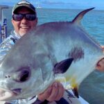
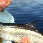
Tarpon
Catch & Release Only
Any Tarpon over 40 inches must remain in the water at all times. Do not drag large fish over the gunwales for photographs.
Pro Tip: You are legally required to have a descending device or venting tool rigged and ready for immediate use on your vessel when targeting reef fish. This ensures the safe, ethical release of non-target species suffering from barotrauma.
REGIONAL ALTERNATIVE
If an unseasonal low-pressure system moves in and the Atlantic offshore bite becomes unfishable due to high seas, Key Largo offers an elite "Plan B." Abandon the ocean side and head west through the cuts into the protected, shallow waters of Florida Bay and the Everglades National Park backcountry (such as Tarpon Basin or Blackwater Sound).
Target Species: Tarpon, Redfish, and Spotted Seatrout.
Tactical Approach: Trade your heavy conventional gear for 3000 to 4000 series spinning outfits loaded with 15lb braided line. The labyrinth of mangrove islands blocks the heavy winds, allowing for comfortable, controlled drifts. Utilize popping corks rigged with live shrimp or cast weedless gold spoons tight to the mangrove shorelines. The water here is shallower and frequently tannin-stained, meaning stealth, quiet boat positioning, and accurate casting will yield far better results than relying solely on your electronics.
Tight lines!
Editor's Choice: Must-Have Gear
FISHINGSIR Next-Gen Waterproof Chest Waders
★★★★★4.4 (7,370+ reviews)
2-Ply Tech: Upgraded nylon with 2.5x higher density than standard fabrics.
100% Waterproof: Lab-approved intrusion resistance with taped visible seams.
Ultra-Lightweight: Designed for all-day comfort while hunting or fishing.
As an Amazon Associate I earn from qualifying purchases. #ad
Loading forecast...
Live Fishing Conditions: Tides, Weather & Waves
Get real‑time tides, marine weather, swell and solunar activity for each spot so you know exactly when conditions line up for your best chance at a bite.
🎣
Key Largo
Loading coordinates...
🌤️
WEATHER CONDITIONS
--°F
--°C
Loading...
🌡️
Feels Like--°F--°C
💧
Humidity--%
💨
Wind-- mph-- km/h
🧭
Direction--
📊
Pressure-- inHg-- hPa
☀️
UV Index--
🌊
MARINE CONDITIONS
🌊Wave Height
-- ft
-- m
Loading...
🧭Wave Direction
--°
Loading...
⏱️Wave Period
-- s
Loading...
📈Tide Status
-- ft
-- m
Loading...
🌙
LUNAR & SOLUNAR
🌕
Loading...
Illumination: --%
Major Period--:-- - --:----:-- - --:--
Minor Period--:-- - --:----:-- - --:--
🌅Sunrise--:--
🌇Sunset--:--
📅
24-HOUR FORECAST
Loading fishing conditions...
Fishing Spots Map
🎣
Book a Fishing Charter near Key Largo Fishing Report Today 🎣
Local guides & charters. Verified captains, instant booking, best price guaranteed.
There was an error loading the map. Please try refreshing the page.
Info
Local Access & Facilities
Key Largo represents more than just the first island in the Florida Keys chain; for the serious angler, it is the threshold between the mainland pressure and the sub-tropical abundance of the archipelago. Situated at the convergence of the Everglades' nutrient-rich backcountry and the crystalline depths of the Atlantic, this fishery offers a diversity of water that few locations can rival. The atmosphere here shifts palpably from the urban sprawl of Homestead into a maritime culture defined by mangroves, coral heads, and the hum of outboards. It is a place where the Atlantic Ocean’s pelagic giants are often just a short run from the dock, yet the technical poling skiff captain can find endless challenges in the skinny water of the bay side.
The topography here is distinct, dominated by the fossilized coral rock that forms the backbone of the island. To the west, the water is stained with tannins and teeming with tarpon and snook in the shadows of the mangroves. To the east, the barrier reef—part of the third-largest reef system in the world—protects the coastline and nurtures massive populations of snapper, grouper, and migratory pelagics. For the seasoned captain, Key Largo serves as a strategic base of operations, offering the logistical convenience of the mainland with the biological richness of the Caribbean. The vibe is less manicured than a resort town but more accessible than the Lower Keys, striking a balance that appeals to anglers who prioritize time on the water over poolside amenities.
Primary targets here vary wildly by season and specific location, but the constants are the reef dwellers and the backcountry prowlers. Whether you are hauling a heavy center console to chase sailfish along the drop-off or towing a technical skiff to hunt bonefish on the oceanside flats, the local infrastructure supports the obsession. The proximity to the Gulf Stream means the blue water is accessible, while the expansive Florida Bay offers sanctuary when the trade winds blow hard from the east.
Access & Getting There
Reaching Key Largo requires navigating the inevitable funnel of U.S. Highway 1 (the Overseas Highway). For anglers towing boats from the mainland, the stretch from Florida City to Key Largo is the critical choke point. Experienced locals know that timing your arrival is as important as checking the tide charts. The two-lane stretch known as the "18 Mile Stretch" can become a parking lot on weekends and holidays. To maximize fishing time, the strategy is always to clear Florida City well before dawn. Once you cross the Jewfish Creek Bridge, you have officially entered the fishing zone, but traffic can still be dense as you move toward the marinas.
For those trailering vessels, the launch situation is anchored by major public facilities like John Pennekamp Coral Reef State Park. This is a high-capacity launch, but it is also one of the most popular tourist destinations in the state. The ramps are generally well-maintained and wide, suitable for larger center consoles, but the sheer volume of recreational kayakers and snorkel tours can create logistical headaches mid-morning. The park offers trailer parking, which is a premium commodity in the Keys, but it fills rapidly. The savvy captain launches at first light, not only to catch the bite but to ensure a parking spot for the trailer is secured before the day-trippers arrive.
💡 Captain's Tip: Beat the Bottleneck
Traffic on the 18 Mile Stretch southbound on Friday afternoons and northbound on Sunday afternoons can add hours to your trip. Plan your haul to cross the bridge before 6:00 AM or after 8:00 PM to avoid the congestion and safeguard your transmission from endless idling.
Weather plays a massive role in accessibility here. Key Largo is exposed to the prevailing easterly trade winds. When the forecast calls for winds exceeding 15 knots from the east or southeast, the oceanside ramps and cuts can become treacherous, particularly for smaller skiffs. In these conditions, the smart play is to utilize access points that dump directly into the Florida Bay or the Intracoastal Waterway (ICW) on the leeward side. The shoreline access points, such as those near Crocodile Lake National Wildlife Refuge, offer calmer alternatives for shore-bound anglers or kayakers looking to avoid the chop, though specific access rules for the refuge must be strictly adhered to.
Parking for vehicles without trailers is available at several designated spots along the Overseas Highway. Locations like the lot at 97450 Overseas Highway and the Basin area provide reliable staging grounds. However, security is always a consideration. While generally safe, leaving a vehicle overnight in an unmonitored lot while you do an overnight offshore trip is not recommended. Stick to the designated marina parking or well-lit public lots like BIRDSPOTS in Tavernier if you are consolidating gear into a buddy's boat.
Key Largo Pre-Trip Checklist
Facilities & Amenities
The infrastructure in Key Largo is built around the marine industry, but finding the right facility for specialized angling needs requires local intel. Unlike the generic big-box stores on the mainland, the shops here are specialized. For bait, Don't Touch The Bait on Ocean Bay Drive is a critical resource for the serious angler because of its 24-hour operation. When you are planning a 3:00 AM departure to catch the falling tide at a specific bridge or to make a long run for swordfish, having access to ice and bait at any hour is a logistical lifesaver. Similarly, JD Outdoor Adventures opens its doors at 6:00 AM, catering specifically to the "dawn patrol" crowd who need to be on the water while the casual tourists are still asleep.
The charter fleet in this region is world-class, though it is spread out. While Key Largo has its own reputable captains, many of the heavy hitters are docked slightly south in Islamorada and Tavernier. Operators like Coastal Outfitters Sport Fishing Charters and Skins and Fins Charters are within a short drive. If you are looking for specific technical charters—such as fly fishing for tarpon—it is often worth the short drive to Tavernier to link up with specialists. The local fleet is known for a high level of professionalism; these are not part-time hobbyists but career captains who depend on the fishery for their livelihood.
💡 Captain's Tip: The 24-Hour Advantage
Nothing kills a trip faster than waiting for a bait shop to open while the tide is running. Utilize the 24-hour access at Don't Touch The Bait to load up on ice and frozen bait the night before, or immediately upon arrival, so you can hit the ramp without delay.
It is important to note a few gaps in amenities. While fuel is readily available at marinas, the price per gallon on the water can be significantly higher than on the highway. Anglers trailering boats should make a habit of fueling up at the larger gas stations in Florida City or along the Overseas Highway before launching. Additionally, while there are fish cleaning stations at major points like Pennekamp, smaller ramps often lack running water or disposal bins. Bring your own heavy-duty trash bags and a cooler dedicated to catch transport to avoid regulatory issues or spoiling the meat.
For accommodation, the area offers a range of options that cater to the boat-towing crowd. Keys Ventures @96 and Sun Outdoors Islamorada are well-regarded for being angler-friendly. For those who prefer a more immersive, rugged experience, the Ernest Coe Campground offers proximity to the Everglades side of the fishery. Staying here puts you in prime position to access the backcountry waters of Whitewater Bay and the coastal prairie, provided you are equipped for the mosquitoes and the heat.
Permits, Regulations & Fees
Navigating the regulatory environment in Key Largo is as complex as navigating its shoals. This area sits at the intersection of multiple protected zones, including the Florida Keys National Marine Sanctuary, Everglades National Park, and state waters. Possession of a standard Florida saltwater fishing license is the baseline, but it is rarely enough if you plan to move between zones. If your fishing takes you into the Everglades National Park boundaries—which is common when fishing the backcountry from Key Largo—you must possess a specific park pass and adhere to their distinct boating safety gear requirements.
The Crocodile Lake National Wildlife Refuge presents a unique regulatory scenario. Established to protect the American crocodile, this area contains critical nesting habitats. While the refuge includes 650 acres of open water, large portions of the land and shoreline are strictly protected to prevent disturbing the crocodiles and the endangered Key Largo woodrat. This is not a place for casual exploration; access is often restricted to specific corridors. Anglers must respect "Area Closed" signage implicitly. The berms created by old canal dredging are favored nesting sites, and stepping onto them is a federal offense that carries heavy fines.
💡 Captain's Tip: Know Your Zones
You can cross invisible boundaries between State Waters, National Marine Sanctuaries, and National Parks within minutes. Each zone has different rules regarding bag limits and gear. Keep a digital chart plotter with overlay zones active to ensure you remain compliant.
Cultural respect is also paramount. The concept of "Kapu"—or forbidden/sacred areas—applies to the ecological sanctuaries here. The coral reefs, particularly around Pennekamp and the sanctuary preservation areas (SPAs), are often "no-take" zones or have restrictions on anchoring to protect the delicate coral structures. Mooring buoys are provided and must be used. Anchoring on coral is not only destructive but illegal. Understanding these regulations is not just about avoiding tickets; it is about ensuring the longevity of the fishery that attracts us all.
Events & Seasonal Information
The rhythm of Key Largo is dictated by the seasons. The winter months bring the "snowbirds" and the sailfish, creating a busy atmosphere on the water and on the highway. During this time, the trade winds are consistent, often making offshore access challenging for smaller vessels. Conversely, the summer months bring the doldrums—flat calm days that are perfect for running deep for swordfish or exploring the far reaches of the backcountry, provided you can handle the intense tropical heat and afternoon thunderstorms.
Major tournaments, particularly those targeting billfish and tarpon, occur primarily in the late spring and summer. During these weeks, the best guides are booked months, sometimes years, in advance, and the boat ramps are at maximum capacity. If you are planning a trip during the Gold Cup Tarpon Tournament or similar events, expect increased pressure on the flats and a higher standard of etiquette required when poling near other skiffs.
Timing your day is critical. In the summer, the bite is often early and late. The mid-day sun shuts down much of the shallow water activity as water temperatures spike. Experienced locals will fish from dawn until 11:00 AM, take a siesta during the heat of the day, and return for the evening bite. In the winter, the window opens up, and mid-day fishing can be productive as the sun warms the flats, activating the crabs and shrimp that bonefish feed on.
Contact Information & Resources
For the most current information on access and conditions, direct contact with managing agencies is recommended. The Ernest F. Coe Visitor Center (Phone: 305-242-7700) is the primary resource for Everglades-related inquiries and is an excellent first stop for orientation if you plan to fish the backcountry. For issues regarding the refuge, the Crocodile Lake National Wildlife Refuge office can be reached at 305-451-4223.
Safety in this environment is self-regulated. Cell reception can be spotty in the backcountry and offshore. Always file a float plan with a reliable contact on land. Heat exhaustion is a genuine threat; carry more water than you think you need. In the event of an emergency, VHF Channel 16 is your lifeline to the Coast Guard, but be aware that response times can vary depending on your distance from the station.
For precise locations, real-time weather conditions, and detailed facility maps, consult the live dashboard and interactive widgets below.
Our spot reports combine data-driven forecasts with curated local information. The forecast is generated by our proprietary Fishing Score algorithm (0–100%), which analyzes real-time data from Open-Meteo API, validated against NOAA CO-OPS tide gauges and USGS water-monitoring stations. The model weights tide dynamics (35%), wave energy (25%), wind patterns (20%) and time of day (20%)—factors shown to influence fish feeding behavior through marine-biology research and decades of charter log data.
Access, facilities and services information for each fishing spot is sourced from official datasets such as Recreation.gov (RIDB), state park & wildlife agencies, and geospatial providers like Google Maps. These sections undergo scheduled re-validation every 3–6 months to ensure that boat ramps, park access, contact details and local services remain accurate.
Narrative sections (catches, seasonal behavior, local tips) are synthesized from these data sources and refined following the Fishing Reports Today editorial guidelines, combining bibliographic research from ichthyology and oceanography with expert angler experience. Our team reviews reports on a regular basis, while the forecast model itself updates every 6 hours for real-time accuracy.
⚠️ Important: Always verify current local regulations, access restrictions and weather conditions before fishing. These reports are intended as a planning aid, not a guarantee of catches or safety. When in doubt, contact local authorities or park managers listed on the page.
To provide the best experiences, we use technologies like cookies to store and/or access device information. Consenting to these technologies will allow us to process data such as browsing behavior or unique IDs on this site. Not consenting or withdrawing consent, may adversely affect certain features and functions.
Functional Always active
The technical storage or access is strictly necessary for the legitimate purpose of enabling the use of a specific service explicitly requested by the subscriber or user, or for the sole purpose of carrying out the transmission of a communication over an electronic communications network.
Preferences
The technical storage or access is necessary for the legitimate purpose of storing preferences that are not requested by the subscriber or user.
Statistics
The technical storage or access that is used exclusively for statistical purposes.The technical storage or access that is used exclusively for anonymous statistical purposes. Without a subpoena, voluntary compliance on the part of your Internet Service Provider, or additional records from a third party, information stored or retrieved for this purpose alone cannot usually be used to identify you.
Marketing & Affiliates
The technical storage or access is required to create user profiles to send advertising, or to track the user on a website or across several websites for similar marketing purposes, including affiliate tracking for products recommended in our reports.


Leave a Reply