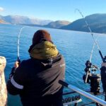
The spring migration is hitting its absolute peak along the Jersey Shore, making this a prime window for anglers. Ocean water temperatures have steadily climbed into the upper 50s and low 60s, which is the exact thermal preference for our premier gamefish to feed aggressively. The surf zone is currently boasting clean, green water with minimal weed interference along the tide line, creating highly fishable conditions from the sand.
However, boaters must exercise extreme CAUTION around the major inlets, particularly Barnegat Inlet and Manasquan Inlet. When a hard outgoing tide clashes with a stiff easterly onshore wind, standing waves will stack up quickly, creating treacherous and potentially unsafe navigation conditions. Always time your inlet crossings during the slack tide if the wind is howling, or opt for the back bays if the ocean swell becomes too aggressive.
🎣Nautrek
Private Beta
J
M
R
100+ anglers on the waitlist
The fishing network where your reputation matters.
Find trusted captains, join real trips with cost splitting, and build your Angler Rank. Your spots stay private — you decide who sees your intel.
The spring run is firing on all cylinders. We are seeing a massive push of quality striped bass in the 30-to-40-inch class dominating the surf, inlets, and back bays. These fish are actively migrating up the coast and staging around heavy structure to ambush prey. The overall abundance of bass is staggering, and the quality of the fish coming over the rails is exactly what you hope for during the peak spring run.
Sleeper Pick: Black Drum
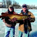
While the majority of the fleet is endlessly chasing striped bass, the night-shift black drum bite has been nothing short of spectacular. Anglers soaking baits after dark in the Delaware Bay and along the southern barrier island beaches are connecting with true prehistoric monsters. We are seeing regular reports of drum pushing past the 60-pound mark. These fish offer incredible pulling power and are entirely overlooked by the plug-casting crowd.
Baitfish Report
The forage base is incredibly diverse right now, which means you need to carry a variety of offerings to match the hatch. Massive pods of adult bunker (menhaden) are moving tight along the beaches, drawing the attention of trophy-sized bass. Right in the wash, the warming water has triggered a massive emergence of sand fleas (mole crabs). In the backwaters and estuaries, bloodworms, grass shrimp, and small spearing are the primary forage driving the bite.
TACTICAL STRATEGY
Where to Deploy
For surfcasters, the northern stretch of Long Beach Island (LBI) up toward Barnegat Light is prime real estate. Do not just cast blindly to the horizon; focus your efforts on the deeper troughs running parallel to the beach and the cuts between the outer sandbars where rip currents form. If you are targeting early-season summer flounder (fluke), direct your attention to the shallow, sun-warmed mudflats of the back bays during the outgoing tide. Specifically, target the 4-to-8-foot drop-offs near the Intracoastal Waterway channels where the water is a few degrees warmer than the surrounding flats.
Lure and Bait Selection
Plugs & Lures: For daytime stripers, jointed glide baits and heavy flutter spoons are producing aggressive reaction strikes. When targeting fluke in the backwaters, a 1/2-ounce to 3/4-ounce bucktail tipped with a 4-inch swimming mullet soft plastic is deadly.
Color Patterns: Bone, white, and bunker-patterned plugs are excelling in the clean ocean surf. In the stained back bays, switch your bucktails and soft plastics to chartreuse, nuclear chicken, or hot pink to maximize visibility.
Live & Cut Bait: Fresh, un-frozen surf clams and bunker chunks are the absolute ticket for both striped bass and black drum. Fish these on a standard fish-finder rig with a short, 40-pound fluorocarbon leader and an 8/0 inline circle hook to ensure a healthy release.
Pro Tip: Do not overlook the shoreline wash! Rig live sand fleas on a standard high-low rig and drop it just past the breaking waves. Striped bass will root through the suds in less than two feet of water to gorge on these crustaceans.
Timing the Bite
The night shift is heavily outperforming daytime hours for trophy striped bass and black drum. Focus your efforts from dusk until the false dawn, especially around the new and full moon phases when the tidal pulls are strongest. For daytime anglers, the last two hours of the incoming tide pushing clean, oxygen-rich ocean water into the inlets has been the most productive feeding window.
Pro Tip: Black sea bass are currently heavily stacked on offshore wrecks and reefs. Until the nearshore waters warm up a few more degrees, you will need to bypass the inshore lumps and target deeper structure in the 80-to-100-foot range to find consistent limits of keeper-sized fish.
REGULATIONS SNAPSHOT
Understanding and strictly adhering to current regulations is critical for preserving these world-class fisheries. Be incredibly careful when handling slot-sized striped bass; always support their belly and minimize their time out of the water to ensure survival.
Note: Always verify local zone exceptions, such as Island Beach State Park or Delaware Bay, before harvesting, as specific zones often have reduced size limits for species like summer flounder.
Species
Minimum Size
Bag Limit
Season Status
Striped Bass
28" to less than 31" (Slot)
1 per angler/day
Open
Summer Flounder (Fluke)
18" (Standard Statewide)
3 per angler/day
Open
Black Sea Bass
12.5"
10 per angler/day
Open
Black Drum
16"
3 per angler/day
Open
Pro Tip: When targeting black drum, make sure your drag is properly set before you cast. These fish are bottom-hugging bulldozers, and a locked-down drag will result in a snapped leader the second a 60-pounder makes a run for deeper water.
REGIONAL ALTERNATIVE
If the ocean surf is blown out by hard onshore winds or heavy ground swells, do not cancel your trip. Instead, retreat to the sheltered backwaters of Barnegat Bay, the Mullica River, or Great Egg Harbor. These inland waters offer a fantastic backup plan, as they rarely get too rough to fish safely and hold plenty of hungry targets.
Target Species: Schoolie Striped Bass and Bluefish
Tactical Approach: Drift the sod banks and marsh islands out of the wind. Throw 3/8-ounce jig heads paired with paddle-tail swimbaits or cast topwater poppers early in the morning. The spring bluefish invasion is in full swing, and these aggressive predators have been pushing deep into the inlets and bays. They will readily crush surface plugs and metal casting jigs, providing non-stop, light-tackle action even when the ocean is completely unfishable. Look for diving birds or nervous water to pinpoint the schools, and always tie on a short trace of heavy fluorocarbon or light wire to prevent their razor-sharp teeth from cutting you off.
Tight lines!
Editor's Choice: Must-Have Gear
FISHINGSIR Next-Gen Waterproof Chest Waders
★★★★★4.4 (7,370+ reviews)
2-Ply Tech: Upgraded nylon with 2.5x higher density than standard fabrics.
100% Waterproof: Lab-approved intrusion resistance with taped visible seams.
Ultra-Lightweight: Designed for all-day comfort while hunting or fishing.
As an Amazon Associate I earn from qualifying purchases. #ad
Loading forecast...
Live Fishing Conditions: Tides, Weather & Waves
Get real‑time tides, marine weather, swell and solunar activity for each spot so you know exactly when conditions line up for your best chance at a bite.
🎣
Jersey Shore
Loading coordinates...
🌤️
WEATHER CONDITIONS
--°F
--°C
Loading...
🌡️
Feels Like--°F--°C
💧
Humidity--%
💨
Wind-- mph-- km/h
🧭
Direction--
📊
Pressure-- inHg-- hPa
☀️
UV Index--
🌊
MARINE CONDITIONS
🌊Wave Height
-- ft
-- m
Loading...
🧭Wave Direction
--°
Loading...
⏱️Wave Period
-- s
Loading...
📈Tide Status
-- ft
-- m
Loading...
🌙
LUNAR & SOLUNAR
🌕
Loading...
Illumination: --%
Major Period--:-- - --:----:-- - --:--
Minor Period--:-- - --:----:-- - --:--
🌅Sunrise--:--
🌇Sunset--:--
📅
24-HOUR FORECAST
Loading fishing conditions...
Fishing Spots Map
🎣
Book a Fishing Charter near Jersey Shore Fishing Report Today 🎣
Local guides & charters. Verified captains, instant booking, best price guaranteed.
There was an error loading the map. Please try refreshing the page.
Info
Local Access & Facilities
Jersey Shore, Pennsylvania, might share a name with a famous coastline, but seasoned anglers know this region for its pristine inland waters and rugged Appalachian valleys. Situated as a gateway to the legendary Pine Creek, this area offers diverse topography ranging from intimate, shaded trout streams to the expansive open waters of nearby reservoirs. The vibe here is decisively rustic, deeply rooted in Pennsylvania's rich angling heritage, and surrounded by dense forests that frame the valley.
Expert fly casters and light-tackle specialists flock to this region to target aggressive wild trout in the moving waters, while heavy-hitting bass anglers look toward the sprawling lakes just a short drive away. The fishery is dynamic, requiring anglers to read water levels, understand seasonal hatches, and navigate a mix of developed parklands and wild, unmanicured riverbanks. It is a destination that rewards local knowledge and diligent preparation.
Whether you are launching a specialized bass boat into a sprawling reservoir or hiking in wading boots along historic rail trails, the logistical landscape of Jersey Shore demands respect. The infrastructure here is a mix of highly developed state park facilities and rugged, bare-bones local access points. Understanding how to navigate these contrasting environments is the key to a successful expedition.
Access & Getting There
Navigating the waterways around Jersey Shore requires a strategic approach to both driving routes and launch timings. For those targeting the moving waters, the Pine Creek Rail Trail serves as the primary artery. The main trailhead parking is located less than a mile from the center of town and is open around the clock. This allows eager anglers to secure premium parking well before the dawn hatch begins.
Further up the trail, access points like Whitetail Access and Ramsey Access offer strategic entry points for wading. These spots are roughly three to six miles out and are highly favored by local guides seeking less pressured water. Parking at these secondary access points can be tight, especially during the peak spring trout season, so arriving early is absolutely critical for securing a spot.
💡 Captain's Tip: Launch Ramp Realities
The three primary local boat ramps are entirely unlit and lack basic amenities like restrooms or fish cleaning stations. Always arrive with your own high-lumen headlamps for pre-dawn launching, and complete all your tackle prep before leaving your hotel or campsite.
For those hauling larger vessels, the premier deep-water access is located about twenty miles away at the Foster Joseph Sayers Dam within Bald Eagle State Park. Accessible via Interstate 80 at Exit 23, this route takes you ten miles north on PA 150. The roads are well-maintained, but heavy trailer haulers should remain vigilant for wildlife crossings during the early morning hours.
Local weather contingencies play a massive role in access strategy. During periods of heavy rain, river access points can become treacherous with fast-moving, muddy water. When river conditions blow out, seasoned captains pivot to the 1,730-acre lake at Bald Eagle State Park. The lake offers a more controlled environment with a fully equipped marina and sheltered coves that provide refuge when valley winds pick up.
Jersey Shore Pre-Trip Checklist
Facilities & Amenities
The local infrastructure caters heavily to the self-reliant angler, though a few specialized shops provide critical support. If you are executing a dawn patrol, Clinger's Bait Tackle and Trapping Supplies is your absolute go-to. Opening at 6:00 AM daily, it is positioned just a few miles from the main access points and stocks the essential gear needed for the local waters. They understand the early rhythms of serious fishermen.
For highly specialized fly fishing gear, anglers must look a bit further out. TCO Fly Shop in Muncy is roughly twenty-two miles away. While they carry top-tier equipment and offer expert local intelligence, they do not open until 10:00 AM. This makes TCO an ideal mid-day stop to restock after your morning session, rather than a pre-launch destination.
💡 Captain's Tip: Negative Knowledge on Amenities
Do not expect to find fuel or ice at the immediate local boat ramps. You must top off your tanks and fill your coolers at convenience stores along the main highway before navigating down to the water's edge.
A unique and highly valuable facility in this region is the Northeast Fishery Center and Lamar National Fish Hatchery. Located about eighteen miles from Jersey Shore, this center conducts cutting-edge research on fish culture and genetics. While not a place to cast a line, visiting the center provides expert anglers with profound insights into the health, behavior, and management of the local wild fish populations.
Lodging logistics should be planned around your target species and launch times. Tarmar Farms operates around the clock, making it ideal for anglers arriving late at night after a long highway haul. Alternatively, Ravensburg State Park offers closer, more rugged accommodations just under seven miles from the primary fishing grounds, perfect for those who want to wake up in the woods.
Facility Name
Category
Distance
Specialty / Notes
Clinger's Bait Tackle
Tackle Shop
3.6 miles
Opens at 6:00 AM; ideal for dawn patrol supplies.
TCO Fly Shop
Fly Shop
22.7 miles
Opens at 10:00 AM; premium fly gear and local intel.
Tarmar Farms
Lodging
16.1 miles
Open 24 hours; excellent for late-night arrivals.
Ravensburg State Park
Lodging/Camping
6.7 miles
Close proximity to trails; rugged outdoor setting.
Permits, Regulations & Fees
Navigating the legal landscape in this region is straightforward but strictly enforced. All fishing regulations are actively managed by the State Fishing Agency. Because this area features a mix of wild trout streams, stocked waters, and large reservoirs, the rules can change dramatically depending on exactly where you drop your line. Familiarizing yourself with the specific waterbody designations is a mandatory part of trip preparation.
The presence of the Lamar National Fish Hatchery underscores the region's commitment to conservation. Certain stretches of water near hatchery tributaries may have specific seasonal closures or tackle restrictions to protect vulnerable breeding populations. These rules are not just bureaucratic; they are essential to maintaining the high caliber of the fishery that draws experts from across the state.
Fortunately, access to the immediate local boat ramps and the Pine Creek Rail Trail parking areas does not require a specific launch fee. However, if you venture out to the highly developed Bald Eagle State Park, be prepared for standard state park regulations. While general access is often free, specific marina services, camping, and specialized facility use will incur costs.
Cultural and environmental respect is paramount. Many of the shore access points, such as the South Avis Playground, are shared with local families and hikers. Furthermore, the region is fully wheelchair accessible in its developed areas. Anglers are expected to practice flawless leave-no-trace ethics, particularly when wading through the delicate riparian zones along the rail trail.
Events & Seasonal Information
The rhythms of the Jersey Shore fishery are entirely dictated by the shifting Appalachian seasons. Spring brings heavy runoff and aggressive trout feeding on massive insect hatches. During this time, the moving waters are the primary draw. By mid-summer, water levels in the creeks drop and temperatures rise, prompting seasoned guides to shift their focus to the deeper, cooler waters of the nearby dams and reservoirs.
Winter transforms the landscape completely. The local facilities, particularly around Foster Joseph Sayers Dam, pivot to support robust winter sports. Ice fishing becomes a major draw when the 1,730-acre lake freezes over solid. Anglers must monitor ice thickness reports diligently, as the varying depths of the reservoir can lead to unpredictable freezing patterns.
💡 Captain's Tip: Timing the Trade Winds
Valley winds tend to funnel aggressively through the Pine Creek corridor by mid-morning. Plan your precision casting for the first three hours of daylight, and switch to heavier tackle or move to sheltered coves by 10:00 AM when the gusts peak.
Tournaments and community fishing events are periodically hosted by the local hatcheries and state parks. The Northeast Fishery Center occasionally runs educational fishing events that draw significant local crowds. If you are planning a quiet, solitary expedition, it is wise to check the state park and hatchery calendars to avoid overlapping with these high-traffic community days.
Contact Information & Resources
Self-reliance is your best asset when fishing the immediate Jersey Shore access points, but knowing who to contact is crucial. The State Fishing Agency is your primary resource for up-to-the-minute regulation changes and water condition alerts. For those utilizing the larger reservoir, the management at Bald Eagle State Park can provide real-time updates on marina status and ramp closures.
If you are interested in the scientific side of the fishery, Steve Davis at the Northeast Fishery Center is the point of contact for scheduling educational tours. In terms of safety, always ensure your vessel has reliable communication gear, as cell service can drop precipitously once you hike or float deep into the river valleys. Always leave a float plan with your lodging host or a local tackle shop.
For precise locations, live weather conditions, and interactive routing to all the ramps and shops mentioned, consult the live dashboard and maps below.
🎣
Jersey Shore
Jersey Shore • Pennsylvania • 41.2020, -77.2644
🅿️
Parking
5
River view Park Parking Lot
⭐ 5.010.3 mi
📍Riverview Park, Palmetto Dr, Lock Haven, PA 17745, USA
Our spot reports combine data-driven forecasts with curated local information. The forecast is generated by our proprietary Fishing Score algorithm (0–100%), which analyzes real-time data from Open-Meteo API, validated against NOAA CO-OPS tide gauges and USGS water-monitoring stations. The model weights tide dynamics (35%), wave energy (25%), wind patterns (20%) and time of day (20%)—factors shown to influence fish feeding behavior through marine-biology research and decades of charter log data.
Access, facilities and services information for each fishing spot is sourced from official datasets such as Recreation.gov (RIDB), state park & wildlife agencies, and geospatial providers like Google Maps. These sections undergo scheduled re-validation every 3–6 months to ensure that boat ramps, park access, contact details and local services remain accurate.
Narrative sections (catches, seasonal behavior, local tips) are synthesized from these data sources and refined following the Fishing Reports Today editorial guidelines, combining bibliographic research from ichthyology and oceanography with expert angler experience. Our team reviews reports on a regular basis, while the forecast model itself updates every 6 hours for real-time accuracy.
⚠️ Important: Always verify current local regulations, access restrictions and weather conditions before fishing. These reports are intended as a planning aid, not a guarantee of catches or safety. When in doubt, contact local authorities or park managers listed on the page.
To provide the best experiences, we use technologies like cookies to store and/or access device information. Consenting to these technologies will allow us to process data such as browsing behavior or unique IDs on this site. Not consenting or withdrawing consent, may adversely affect certain features and functions.
Functional Always active
The technical storage or access is strictly necessary for the legitimate purpose of enabling the use of a specific service explicitly requested by the subscriber or user, or for the sole purpose of carrying out the transmission of a communication over an electronic communications network.
Preferences
The technical storage or access is necessary for the legitimate purpose of storing preferences that are not requested by the subscriber or user.
Statistics
The technical storage or access that is used exclusively for statistical purposes.The technical storage or access that is used exclusively for anonymous statistical purposes. Without a subpoena, voluntary compliance on the part of your Internet Service Provider, or additional records from a third party, information stored or retrieved for this purpose alone cannot usually be used to identify you.
Marketing & Affiliates
The technical storage or access is required to create user profiles to send advertising, or to track the user on a website or across several websites for similar marketing purposes, including affiliate tracking for products recommended in our reports.


Leave a Reply