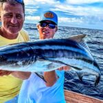
0%

Daytona Beach, FL Fishing Report Today 🎣

4 months ago · Updated 2 weeks ago

Daytona Beach Fishing Report: Winter Sheepshead Peak & River Giants

Region: Daytona Beach / Ponce Inlet / St. Johns River
Report Status: GO - PRIME WINTER PATTERNS
Water Temp: 61°F - 64°F (Cooling Trend)
Wind: Moderate North/Northeast (Check daily marine forecast)

1. GO/NO-GO STATUS

Verdict: GO.

We are squarely in the winter transition, which filters out the fair-weather anglers and leaves the die-hards with excellent opportunities. The Sheepshead bite is currently rated "Red Hot" at Ponce Inlet, providing the most reliable action for table fare. However, a CAUTION advisory is in effect for small skiffs near the inlet mouth due to stiff North winds whipping up the outgoing tide. If the inlet is too rough, the St. Johns River offers protected water where massive Longnose Gar are schooling in record numbers.


2. SPECIES INTEL (Bio-Verified)

PRIMARY TARGET: Sheepshead (Archosargus probatocephalus)

  • Activity Level: HIGH (Verified by recent catch reports and seasonal timing).
  • Why Now: Cold fronts push these structure-loving sparids to congregate around the Ponce Inlet jetties and bridge pilings to spawn. They are aggressive and feeding heavily on crustaceans.
  • Bio Note: While they rank #15 in our observation data, this is deceptive; they are currently the most targeted species by pros.

SLEEPER PICK: Longnose Gar (Lepisosteus osseus)

  • Activity Level: EXTREME (Ranked #1 in Biological Data).
  • The Intel: Our biological ground truth data shows an explosion of Gar observations (22 confirmed sightings) in the last 30 days, specifically near Orange City and Blue Spring State Park. While tourists watch them from the boardwalk, savvy anglers are targeting them in the main St. Johns River channel where they are actively hunting.
  • Size Class: Trophy potential. Specimens over 40 inches are common right now.

BAITFISH REPORT: Matching the Hatch

  • Pinfish (Rank #3): Abundant in the Indian River Lagoon. Small live pinfish are the superior bait for Snook and large Redfish right now.
  • Sea Mullet (Rank #11): Schools are thinning out, but cut mullet remains the best scent bait for Redfish and Gar.

3. TACTICAL STRATEGY

SCENARIO A: The "Convict" Sweep (Saltwater)

Location: Ponce de Leon Inlet Jetties (North side for safer footing, South side for boat access) and the Dunlawton Bridge pilings.

  • The Setup: You need to scrape the barnacles to ring the dinner bell. Use a flat-blade shovel or hoe (where legal) to scrape a piling, then drop your bait directly into the chum cloud.
  • Terminal Tackle:
    • Rig: 1/2 oz to 1 oz "Sheepshead Jig" (boxing glove shape) or a knocker rig with a #1 or #2 Mosquito hook.
    • Leader: 20lb Fluorocarbon (Essential—the water is clearer in winter).
  • Bait: Fiddler Crabs are the gold standard. Sand Fleas are a close second. If you can't get those, live shrimp threaded tail-first work, but expect "bait stealers" like Pinfish to harass you.
  • Timing: The last 2 hours of the incoming tide and the first hour of the outgoing. The slack tide allows for the most precise vertical presentation.

Pro Tip: "Set the hook before you feel the bite." Sheepshead are notorious thieves. If you feel weight or a 'crunchy' sensation, lift the rod tip sharply. Do not wait for a tug.

SCENARIO B: River Monster Hunting (Freshwater)

Location: St. Johns River, specifically near the confluence of the Blue Spring Run (Orange City). WARNING: Fishing is prohibited inside the Blue Spring Run during Manatee Season (Nov 15 - Mar 31). You must anchor in the main river channel at the mouth of the run.

  • The Setup: Gar are surfacing to breathe air and patrolling the drop-offs near the spring outflow, looking for stunned baitfish.
  • Terminal Tackle:
    • Lure: 3-4 inch frayed nylon rope lure (no hooks). The gar's teeth get tangled in the nylon.
    • Bait Rig: Carolina rig with a steel leader (12 inches) and a #2/0 circle hook baited with a chunk of Cut Mullet or Shiner.
  • Technique: Cast into the eddy where the clear spring water mixes with the tannic river water. Let the bait sit on the bottom.

4. REGULATIONS SNAPSHOT (2026 Verified)

SpeciesMin Size (Total Length)Daily Bag LimitNotes
Sheepshead12 inches8 per harvesterMust remain in whole condition.
Gray (Mangrove) Snapper10 inches5 per harvesterState waters rule.
Red Drum (Redfish)18" min - 27" max1 per harvesterSlot limit is strictly enforced.
Longnose GarNo Size LimitNo Bag LimitFlorida resident license required.

5. REGIONAL ALTERNATIVE

Condition: If Ponce Inlet is blown out by 20+ knot North winds (unsafe for small craft).

The Move: Mosquito Lagoon (North End).

  • Access: Launch at Riverbreeze Park (Oakhill) or JB's Fish Camp.
  • Target: Black Drum and Speckled Trout.
  • Tactic: Find deep holes (3-5ft) in the flats or residential canals. Dead stick a piece of peeling shrimp or blue crab on a jig head. The fish are cold and lethargic; they will not chase a fast-moving lure. Slow down your retrieve to a crawl.

Tight lines!

Loading forecast...

Live Fishing Conditions: Tides, Weather & Waves

Get real‑time tides, marine weather, swell and solunar activity for each spot so you know exactly when conditions line up for your best chance at a bite.

🎣

Daytona Beach, FL

Loading coordinates...

🌤️

WEATHER CONDITIONS

Weather
-- °F
--°C

Loading...

🌡️
Feels Like --°F --°C
💧
Humidity --%
💨
Wind -- mph -- km/h
🧭
Direction --
📊
Pressure -- inHg -- hPa
☀️
UV Index --
🌊

MARINE CONDITIONS

🌊 Wave Height
-- ft
-- m
Loading...
🧭 Wave Direction
--°
Loading...
⏱️ Wave Period
-- s
Loading...
📈 Tide Status
-- ft
-- m
Loading...
🌙

LUNAR & SOLUNAR

🌕

Loading...

Illumination: --%

Major Period --:-- - --:-- --:-- - --:--
Minor Period --:-- - --:-- --:-- - --:--
🌅 Sunrise --:--
🌇 Sunset --:--
📅

24-HOUR FORECAST

Loading fishing conditions...

Fishing Spots Map

My location
Loading map...

Local Access & Facilities

Introduction

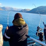
Daytona Beach offers a convergence of aquatic environments that few other fisheries in Florida can match. To the east, the hard-packed sands of the Atlantic coast provide a legendary surf fishing arena where anglers can drive their vehicles directly to the water's edge. Inland, the Halifax River—part of the Intracoastal Waterway—offers a brackish playground for inshore game fish. Yet, for the serious angler willing to trailer a boat slightly west, the St. Johns River system and the Lake Woodruff National Wildlife Refuge present a prehistoric landscape of freshwater marshes, hardwood swamps, and dark water teeming with bass and panfish. This is a fishery defined by its variety, requiring a captain who can switch gears from heavy surf casting to technical shallow-water poling within the same weekend.The atmosphere here shifts dramatically depending on your chosen heading. The beachfront is energetic, historic, and often busy, characterized by the rumble of vehicles on sand and the rhythmic crashing of the Atlantic. Conversely, the backcountry of the Canaveral National Seashore to the south and the refuge to the west offers profound silence, broken only by the cry of a limpkin or the splash of a gator. For the expert angler, Daytona is not just a destination; it is a logistical hub. It serves as the perfect launchpad for targeting migratory Pompano in the surf, bull Redfish in the cuts, or trophy Largemouth Bass in the untamed wilderness.Navigating this region requires an understanding of distinct ecosystems. The transition from the high-energy saltwater coast to the tea-colored freshwater swamps happens over just a few miles of asphalt. Seasoned skippers know that success here relies on playing the wind and tides. When the Atlantic trade winds blow out the surf, the leeward mangroves of the Mosquito Lagoon or the sheltered creeks of Lake Woodruff offer viable, productive alternatives. This guide breaks down the essential access points, facilities, and regulations you need to effectively work these waters.

💡 Captain's Tip: Playing the Wind

Daytona's geography offers a unique advantage: versatility. If the easterly trade winds exceed 15 knots, blowing out the beach and the main Halifax River channel, trailer west to Lake Woodruff. The heavy timber and marsh grass provide excellent windbreaks, allowing you to fish calm freshwater pockets even when the coast is unfishable.

Access & Getting There

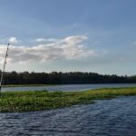
Accessing the prime fishing grounds around Daytona Beach requires a strategic approach to traffic and launch selection. The area is bisected by I-95 and US-1, which serve as the primary north-south arteries. For those towing vessels, International Speedway Boulevard is the main east-west connector, linking the beachside ramps to the inland freshwater fisheries. Traffic on these routes can be heavy during peak tourist seasons and race weeks; expert anglers plan their haul-outs for early dawn or late evening to avoid the mid-day congestion common near the speedway and beach approaches.For surf anglers, the Seabreeze Blvd Beach Vehicle Ramp is a critical access point. Located centrally at 29.2356° N, -81.0121° W, this ramp allows four-wheel-drive vehicles to access the sand. Unlike standard parking lots, this access puts your cooler and rod holders mere feet from the breaking surf. However, access is tide-dependent. High tides can narrow the drivable beach significantly, and soft sand pockets are common near the dunes. It is imperative to air down tires if you are driving a heavier rig and to check the tide tables before committing to a spot for the day.Boat access to the freshwater interior centers around the Lake Woodruff National Wildlife Refuge, located approximately 25 miles west of the city. The primary access is via DeLeon Springs. From Highway 17, seasoned navigators turn west onto Grand Avenue and then south to Mud Lake Road. The refuge headquarters is located at 2045 Mud Lake Road. The launch situation here is primitive compared to the coastal marinas; it is designed for johnboats, skiffs, and kayaks suitable for navigating narrow canals and shallow marshes. There are no high-capacity concrete mega-ramps here; preparation and a shallow-draft vessel are prerequisites for success.To the south, accessing the Canaveral National Seashore and the famous Mosquito Lagoon requires trailering down US-1 to Oak Hill or New Smyrna Beach. Access points here open up to the Intracoastal Waterway. The boat access near Riverbreeze Park (referenced in camping data for Bissette Bay) serves as a gateway to the spoil islands and backcountry flats. The channels here are marked, but the flats are notoriously shallow. Local knowledge of the "zones" is vital, as running aground in the protected seagrass beds carries stiff fines and potential prop damage.

💡 Captain's Tip: Shallow Water Navigation

When accessing campsites like Brickhouse Cove in the southern lagoon, a standard bay boat may not suffice. The approach is extremely shallow. Experienced locals utilize technical poling skiffs, canoes, or kayaks to reach these secluded zones. Always check your draft against the tide chart before attempting to access the interior spoil islands.

Daytona Beach, FL Pre-Trip Checklist

Facilities & Amenities

The infrastructure in Daytona Beach caters to a broad spectrum of anglers, from the heavy-tackle surf caster to the fly-fishing purist. For bait and tackle, Donald's Bait & Tackle in Port Orange is a staple for the dawn patrol crowd. Located at 96 Dunlawton Ave, they open at 5:00 AM most days, allowing captains to stock up on live shrimp and ice before the sun breaks the horizon. Their proximity to the Dunlawton Bridge makes them a convenient stop for those fishing the Halifax River.For those pushing further south towards the inlet or lagoon, E & J Bait and Tackle on S Ridgewood Ave offers extended hours, staying open until 10:00 PM or even 12:00 AM on weekends. This is crucial for night anglers targeting Snook under the dock lights or preparing for a midnight shark fishing session in the surf. Further north in Ormond Beach, Fish On Bait & Tackle opens at 6:00 AM, servicing anglers heading toward the Tomoka Basin. If your expedition takes you south to the Mosquito Lagoon, Chums Bait Shop & General Store on Turtlemound Rd is the last logistical outpost, located roughly 21.9 miles from the city center.When it comes to marine services, the area has specialized support. Cycle Gear on W International Speedway Blvd is available for small engine parts and maintenance supplies often needed by DIY boaters. For those seeking guided expertise, the local fleet is robust. On The Hook Fishing Charters and Daytona Beach Fishing Charters operate locally, offering insight into the current bite. These captains are essential resources for understanding the seasonal movements of migratory stocks along the coast.Lodging options for the traveling angler vary by target species. For freshwater enthusiasts focused on the St. Johns River system, Highland Park Fish Camp in DeLand is a legendary institution. Located 25 miles from the coast, it offers direct access to the bass grounds and understands the needs of boaters. Closer to the coast, Lake Belle RV Resort in Holly Hill provides a central location for RV-based anglers fishing the Halifax River.However, the crown jewel of local accommodation for the adventurous is the backcountry camping within Canaveral National Seashore. This is not a facility with electricity or running water; it is a raw, boat-in experience. There are fourteen designated island campsites, including Government Cut (accommodating up to 20 people), Orange Island (small groups of 6), and Headwinds. These sites offer zero amenities—no ice, no fuel, no fresh water. You must pack in every ounce of water and pack out every piece of trash. The reward is waking up on a spoil island surrounded by tailing Redfish.

💡 Captain's Tip: Provisioning for the Islands

If you plan to camp at Canaveral National Seashore, note that there are absolutely no amenities on the islands. "Missing amenities" here means everything. You must bring portable waste systems (if required by current regs), ample freshwater (1 gallon per person/day minimum), and heavy-duty bug protection. The mosquitoes in the lagoon are legendary for a reason.

Permits, Regulations & Fees

Fishing in Daytona Beach falls under the jurisdiction of the State Fishing Agency, and strict adherence to licensing is mandatory. Florida requires separate licenses for freshwater and saltwater fishing. If you plan to fish the brackish transition zones where the Halifax River meets freshwater creeks, it is prudent to carry both. Enforcement is active, particularly at high-traffic ramps and beach access points.For those venturing into the Canaveral National Seashore, a specific permitting system is in place for backcountry camping. Reservations are mandatory and can be made up to six months in advance. The fee is currently $25 per night. It is critical to note that you must secure your specific island site—such as Bissette Bay or Scout Island—at the time of booking. The permit system is rigid: changes to the date of entry require a full cancellation and re-booking. No-shows forfeit their fees, and refunds are generally only issued for administrative closures or extreme weather events.The Lake Woodruff National Wildlife Refuge operates under specific federal regulations to protect migratory birds and wilderness character. While fishing is a recognized activity, it is secondary to the refuge's conservation mission. Special restrictions often apply to motor usage in designated Wilderness Areas. For example, the Lake Woodruff Wilderness covers 1,066 acres, including Bird Island and Dexter Island. In these zones, the "leave no trace" ethic is not just a suggestion; it is law. Airboats and high-speed running may be restricted in specific impoundments or during waterfowl nesting seasons.Cultural respect is also paramount. The region has a deep history, from the Timucuan Indian populations to early settlers. Mounds and middens are present in the Lake Woodruff area and along the lagoon. These are protected archaeological sites. Disturbing artifacts or walking on sensitive midden mounds is strictly prohibited. The concept of "Kapu" or sacredness should be applied to these historical footprints; anglers are guests in a landscape that has supported fishing cultures for thousands of years.

Events & Seasonal Information

The fishing calendar in Daytona is dictated by the rhythms of migration and weather. In the Lake Woodruff NWR, the water levels and bird migrations define the seasons. Ducks account for more than half of the migratory birds, arriving in the cooler months. For anglers, spring (May and June) marks the movement of manatees into the refuge and nearby springs, signaling warming waters that fire up the warm-water game fish.On the coast, the transition from winter to spring brings the cobia run and the return of pompano to the surf. Summer offers calmer seas for nearshore tarpon but brings the intense heat and daily thunderstorms characteristic of Central Florida. The "dawn patrol" isn't just about beating the crowds; it's a safety necessity to get off the open water before the afternoon lightning storms build over the mainland.Tournament season typically heats up in the summer months, with various Kingfish and Tarpon tournaments drawing crowds. However, the backcountry angler looks for the winter tides in the Mosquito Lagoon. Lower water levels in winter concentrate the fish in the deeper holes and channels, making sites like Government Cut and Shipyard Island prime basecamps for technical winter fishing.

Contact Information & Resources

For the most current information on water levels, closures, and permits, direct contact with managing agencies is essential. Lake Woodruff National Wildlife Refuge: The headquarters can be reached at 386-985-4673 or via email at lakewoodruff@fws.gov. They are the authority on access to the western freshwater wilderness. Canaveral National Seashore: For camping permits and lagoon conditions, contact the visitor center or ranger station. While a direct phone line for the permit desk varies, general park information is crucial for checking on island closures.* Emergency & Safety: Cell reception can be spotty in the refuge and the deeper parts of the lagoon. A VHF radio is standard equipment for any boat heading into the backcountry. In case of emergency on the water, the Coast Guard monitors Channel 16.For precise locations of the boat ramps, detailed boundaries of the wilderness areas, and real-time weather conditions, consult the live dashboard and interactive maps below.
🎣

Daytona Beach, FL

Daytona Beach • Florida • 29.2367, -81.0074
🅿️

Parking

5
Platinum Painting and Coatings Inc.
⭐ 4.9 6.7 mi
📍 1414 Royal Grove Ln, Port Orange, FL 32129, USA
🕒
Monday: 8:00 AM – 6:00 PM
Tuesday: 8:00 AM – 6:00 PM
Wednesday: 8:00 AM – 6:00 PM
Thursday: 8:00 AM – 6:00 PM
Friday: 8:00 AM – 6:00 PM
Saturday: 8:00 AM – 6:00 PM
Sunday: 8:00 AM – 6:00 PM
🚗 Get Directions
Cycle Gear
⭐ 4.8 4.8 mi
📍 1808 W International Speedway Blvd Ste 104, Daytona Beach, FL 32114, USA
🕒
Monday: 10:00 AM – 7:00 PM
Tuesday: 10:00 AM – 7:00 PM
Wednesday: 10:00 AM – 7:00 PM
Thursday: 10:00 AM – 7:00 PM
Friday: 10:00 AM – 7:00 PM
Saturday: 10:00 AM – 6:00 PM
Sunday: 10:00 AM – 6:00 PM
🚗 Get Directions
Custom Lighting Efx
⭐ 4.8 8.1 mi
📍 1170 U.S. Rte 1, Ormond Beach, FL 32174, USA
🕒
Monday: 9:00 AM – 5:00 PM
Tuesday: 9:00 AM – 5:00 PM
Wednesday: 9:00 AM – 5:00 PM
Thursday: 9:00 AM – 5:00 PM
Friday: 9:00 AM – 6:00 PM
Saturday: Closed
Sunday: Closed
🚗 Get Directions
LAZ Parking - Ocean Center
⭐ 4.7 0.6 mi
📍 101 N Atlantic Ave, Daytona Beach, FL 32118, USA
🕒
Monday: Open 24 hours
Tuesday: Open 24 hours
Wednesday: Open 24 hours
Thursday: Open 24 hours
Friday: Open 24 hours
Saturday: Open 24 hours
Sunday: Open 24 hours
🚗 Get Directions
🐟

Bait & Tackle

5
92 Tackle
⭐ 5.0 20.5 mi
📍 1324 E International Speedway Blvd, DeLand, FL 32724, USA
🕒
Monday: 10:00 AM – 5:00 PM
Tuesday: 10:00 AM – 5:00 PM
Wednesday: 10:00 AM – 5:00 PM
Thursday: 10:00 AM – 5:00 PM
Friday: 10:00 AM – 5:00 PM
Saturday: 10:00 AM – 5:00 PM
Sunday: Closed
🚗 Get Directions
Fish On Bait & Tackle
⭐ 4.9 13.1 mi
📍 35 High Bridge Rd Suite A, Ormond Beach, FL 32174, USA
🕒
Monday: 6:00 AM – 6:00 PM
Tuesday: 6:00 AM – 6:00 PM
Wednesday: 6:00 AM – 6:00 PM
Thursday: 6:00 AM – 6:00 PM
Friday: 6:00 AM – 6:00 PM
Saturday: 6:00 AM – 6:00 PM
Sunday: 6:00 AM – 6:00 PM
🚗 Get Directions
Chums Bait Shop & General Store
⭐ 4.9 21.9 mi
📍 6495 Turtlemound Rd, New Smyrna Beach, FL 32169, USA
🕒
Monday: 8:00 AM – 4:00 PM
Tuesday: 8:00 AM – 4:00 PM
Wednesday: 8:00 AM – 4:00 PM
Thursday: 8:00 AM – 4:00 PM
Friday: 8:00 AM – 4:00 PM
Saturday: 8:00 AM – 4:00 PM
Sunday: 8:00 AM – 4:00 PM
🚗 Get Directions
Donald's Bait & Tackle
⭐ 4.8 6.5 mi
📍 96 Dunlawton Ave, Port Orange, FL 32127, USA
🕒
Monday: 5:00 AM – 7:00 PM
Tuesday: 5:00 AM – 7:00 PM
Wednesday: 5:00 AM – 7:00 PM
Thursday: 5:00 AM – 7:00 PM
Friday: 5:00 AM – 8:00 PM
Saturday: 5:00 AM – 8:00 PM
Sunday: 5:00 AM – 7:00 PM
🚗 Get Directions
E & J Bait and Tackle
⭐ 4.8 7.9 mi
📍 5253 S Ridgewood Ave, Port Orange, FL 32127, USA
🕒
Monday: 6:00 AM – 10:00 PM
Tuesday: 6:00 AM – 10:00 PM
Wednesday: 6:00 AM – 10:00 PM
Thursday: 6:00 AM – 10:00 PM
Friday: 6:00 AM – 12:00 AM
Saturday: 6:00 AM – 12:00 AM
Sunday: 6:00 AM – 8:00 PM
🚗 Get Directions
🚤

Fishing Charters

2
On The Hook Fishing Charters in Daytona Beach
⭐ 5.0 5.1 mi
📍 1 Oceans W Blvd, Daytona Beach Shores, FL 32118, USA
🕒
Monday: Open 24 hours
Tuesday: Open 24 hours
Wednesday: Open 24 hours
Thursday: Open 24 hours
Friday: Open 24 hours
Saturday: Open 24 hours
Sunday: Open 24 hours
🚗 Get Directions
Daytona Beach Fishing Charters
⭐ 5.0 3.0 mi
📍 11 Robben Terrace, Daytona Beach, FL 32118, USA
🕒
Monday: Open 24 hours
Tuesday: Open 24 hours
Wednesday: Open 24 hours
Thursday: Open 24 hours
Friday: Open 24 hours
Saturday: Open 24 hours
Sunday: Open 24 hours
🚗 Get Directions
🏠

Lodging

5
Lake Belle RV Resort
⭐ 5.0 3.0 mi
📍 490 Flomich St, Holly Hill, FL 32117, USA
🕒
Monday: 9:00 AM – 5:00 PM
Tuesday: 9:00 AM – 5:00 PM
Wednesday: 9:00 AM – 5:00 PM
Thursday: 9:00 AM – 5:00 PM
Friday: 9:00 AM – 5:00 PM
Saturday: 9:00 AM – 5:00 PM
Sunday: 9:00 AM – 5:00 PM
🚗 Get Directions
Daytona 200 Motorcycle Club
⭐ 4.9 9.8 mi
📍 3602 W International Speedway Blvd, Daytona Beach, FL 32124, USA
🕒
Monday: 9:00 AM – 6:00 PM
Tuesday: 9:00 AM – 6:00 PM
Wednesday: 9:00 AM – 6:00 PM
Thursday: 9:00 AM – 6:00 PM
Friday: 9:00 AM – 6:00 PM
Saturday: 9:00 AM – 6:00 PM
Sunday: 9:00 AM – 6:00 PM
🚗 Get Directions
Highland Park Fish Camp
⭐ 4.6 25.0 mi
📍 2640 Highland Park Rd, DeLand, FL 32720, USA
🕒
Monday: 6:00 AM – 5:00 PM
Tuesday: 6:00 AM – 5:00 PM
Wednesday: 6:00 AM – 5:00 PM
Thursday: 6:00 AM – 5:00 PM
Friday: 6:00 AM – 5:00 PM
Saturday: 6:00 AM – 5:00 PM
Sunday: 6:00 AM – 5:00 PM
🚗 Get Directions

Boat Ramps

3
🚻

Restrooms

3
👨‍👩‍👧‍👦

Family Friendly

2

Accessibility

Wheelchair Access

Available

🐕

Pets Allowed

Not Confirmed

⚠️ Some accessibility info not officially confirmed. Please verify with location directly.

📍 Showing 25 facilities on map

📊

About Our Fishing Reports & Forecasts

Our spot reports combine data-driven forecasts with curated local information. The forecast is generated by our proprietary Fishing Score algorithm (0–100%), which analyzes real-time data from Open-Meteo API, validated against NOAA CO-OPS tide gauges and USGS water-monitoring stations. The model weights tide dynamics (35%), wave energy (25%), wind patterns (20%) and time of day (20%)—factors shown to influence fish feeding behavior through marine-biology research and decades of charter log data.

Access, facilities and services information for each fishing spot is sourced from official datasets such as Recreation.gov (RIDB), state park & wildlife agencies, and geospatial providers like Google Maps. These sections undergo scheduled re-validation every 3–6 months to ensure that boat ramps, park access, contact details and local services remain accurate.

Narrative sections (catches, seasonal behavior, local tips) are synthesized from these data sources and refined following the Fishing Reports Today editorial guidelines, combining bibliographic research from ichthyology and oceanography with expert angler experience. Our team reviews reports on a regular basis, while the forecast model itself updates every 6 hours for real-time accuracy.

⚠️ Important: Always verify current local regulations, access restrictions and weather conditions before fishing. These reports are intended as a planning aid, not a guarantee of catches or safety. When in doubt, contact local authorities or park managers listed on the page.

Learn more about our methodology & data sources

Leave a Reply

Your email address will not be published. Required fields are marked *