
The South Platte Impoundment: A Strategic Overview
Situated on the South Platte River just southwest of Littleton, Chatfield Reservoir serves as a critical flood control structure that has evolved into a premier recreational fishery. Spanning 1,479 acres of surface water surrounded by over 5,000 acres of parkland, this body of water offers a diverse aquatic environment ranging from deep channels near the dam to expansive flats. The reservoir acts as the second line of defense against regional floods, creating a dynamic ecosystem where water levels can fluctuate, constantly reshaping the littoral zones that experienced anglers target.
The atmosphere here is a unique blend of suburban accessibility and rugged Front Range beauty. While the hum of the nearby highway is audible, the backdrop features the dramatic red-rock formations of the foothills and stands of Ponderosa pine and Gamble oak. It is a fishery that demands versatility, where captains must be prepared to switch from open-water trolling to working structure along the riparian edges.
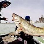
For the serious angler, the draw here is the volume of water and the variety of structure. Unlike smaller municipal ponds, Chatfield provides enough acreage to run a proper center console or bass boat, allowing for the use of advanced electronics to locate schools in the main basin. The presence of the Chatfield Nature Preserve nearby ensures that water quality and environmental integrity remain high priorities for the management agencies.
Access & Getting There
Accessing the reservoir is straightforward for those familiar with the Denver Metro area, but timing is critical. The primary route involves taking C-470 to the Wadsworth Boulevard interchange. Because this is a major commuter artery, traffic can be heavy during weekday rush hours. Seasoned skippers know that towing a wide-beam boat through this corridor requires patience between 4:00 PM and 6:00 PM; a pre-dawn departure is always the superior strategy to beat the congestion.
Once inside the State Park, the launch infrastructure is robust but can get crowded. The facility features multiple launch points, with the South Boat Launch being a primary target for those looking to access the upper reaches of the reservoir quickly. The ramps are generally well-maintained concrete, suitable for larger fiberglass hulls. However, water level fluctuations managed by the Army Corps of Engineers can alter the ramp angle and traction, so inspecting the waterline before backing down is standard procedure.
💡 Captain's Tip: Trailer Management
While the South Boat Launch offers dedicated trailer parking, these spots fill rapidly on summer weekends. Plan to be at the gate when it opens, or consider a mid-week assault to ensure you have ample room to maneuver your rig without the pressure of a waiting line.
Weather on the Front Range is notoriously volatile. The reservoir is exposed to winds coming off the foothills, and conditions can shift from glass-calm to whitecaps in under 30 minutes. When the forecast calls for gusts over 15 mph, the open center of the lake becomes challenging for smaller craft. In these conditions, sticking to the leeward coves or the protected waters near the Jamison Picnic Area or Deer Creek Day Use areas is a prudent move.
Chatfield Reservoir Pre-Trip Checklist
Facilities & Amenities
While the park itself is well-equipped for recreation, anglers often need to look just outside the boundaries for specialized support. For bait and immediate tackle needs, Ken's Anglers is the closest reliable outpost, located just 3.4 miles from the water. Opening at 7:00 AM daily, it is the logical pitstop for live bait and local intelligence before hitting the ramp. For more extensive gear requirements, Discount Fishing Tackle on South Santa Fe Drive (approx. 9.9 miles away) offers a broader selection of hard goods.
Fly fishermen targeting the river inlets or shallows should note the presence of The Confluence Rod Company and Fly Fish Colorado in the wider region. These resources indicate a healthy local culture of fly angling, suggesting that the reservoir's tributaries and flats hold potential for those willing to wield a long rod. If you are looking to hire local knowledge, River Trekker Outfitters operates in the area, providing guided expertise that can cut the learning curve significantly.
💡 Captain's Tip: Fuel Logistics
There is no dedicated fuel dock listed explicitly for the launch areas in the immediate facility data. Captains should operate under the assumption that they need to fuel up on the highway before entering the park. Running dry on 1,400 acres of water is a mistake you only make once.
For multi-day excursions, on-site options are available but geared towards camping. The Indian Creek Equestrian Campground, located about 10.4 miles away, offers a rustic base camp, particularly for those who might be combining angling with packing in on horseback. This facility provides gravel driveways and is strictly for those in possession of a horse, so standard boat-camping anglers should look to the main park campgrounds or nearby accommodation like the NYR-Nationwide Youth Roundup facility for lodging.
Permits, Regulations & Fees
Navigating the regulatory environment at Chatfield requires attention to both state and federal rules. As a State Park leasing land from the Army Corps of Engineers, the area is managed strictly to balance recreation with flood control and conservation. A valid State Parks pass is typically required for vehicle entry, in addition to any vessel registration fees. Fishing activities fall under the jurisdiction of the state fishing agency, and officers patrol both the gates and the water frequently.
Conservation zones are a critical aspect of this fishery. The Chatfield Nature Preserve is a sensitive area dedicated to environmental study. Anglers must respect all buoy lines and signage demarcating restricted zones. These areas act as nurseries and sanctuaries for the bird populations and aquatic life that sustain the fishery. Ignorance of a "No Wake" or "Exclusion Zone" marker is not a valid defense here.
Cultural respect is also paramount. The Hildebrand Homestead, listed on the National Register of Historic Places, is located within the vicinity. While primarily a land-based attraction, its presence serves as a reminder of the historical significance of the South Platte valley. Anglers utilizing the shoreline access points near Deer Creek should be mindful of leaving no trace to preserve the integrity of these public lands.
Events & Seasonal Information
The reservoir operates as a year-round fishery, though the tactics change drastically with the seasons. Summer brings heavy recreational boat traffic—wakeboarders and jet skis—which forces serious anglers to adjust their clocks. The "Dawn Patrol" is essential from June through August; the best fishing window is often closing just as the recreational fleet is launching at 10:00 AM. Conversely, the shoulder seasons of late fall and early spring offer solitude and often the most aggressive feeding windows as fish prepare for or recover from winter.
💡 Captain's Tip: Wind Patterns
Local skippers watch the flags. The typical weather pattern involves calm mornings followed by afternoon thunderstorms rolling off the mountains. If you see towering cumulus clouds building over the foothills to the west, it is time to pull the trolling motor and head for the ramp immediately.
While specific tournament schedules vary annually, the size and accessibility of Chatfield make it a frequent host for local club derbies and regional competitive circuits. These events usually launch from the main ramps at first light. If you are not competing, check the local boards or ask at Ken's Anglers about scheduled events to avoid the congestion of a 50-boat blast-off.
Contact Information & Resources
For the most current information regarding water levels, ramp closures, or emergency alerts, direct contact with the managing agencies is recommended. The regional ranger district can be reached at 303-275-5610. This line is particularly useful for checking on conditions at the Indian Creek area or general forest service notices that might impact the watershed.
Safety on the water is the responsibility of the captain. Cell reception is generally good across the reservoir due to its suburban proximity, but dead zones can exist in the deep channels near the dam. Always file a float plan and ensure your safety gear exceeds the minimum Coast Guard requirements.
For precise locations of the boat ramps, real-time weather data, and detailed locations of the tackle shops mentioned above, consult the live dashboard and interactive maps below.


Leave a Reply