Camp Far West Reservoir Fishing Report: Summer Pattern Update
1. GO/NO-GO STATUS
Verdict: CAUTION — EARLY GO
As we push deep into the summer season, Camp Far West Reservoir transitions into a highly dynamic and dual-use fishery. The current status is a definitive green light for early risers, but demands extreme caution by midday. Rapidly warming air temperatures have pushed surface water temperatures into the upper 70s and low 80s, establishing a distinct thermocline across the main lake body.
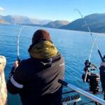
While the morning bite is highly productive, anglers must be off the main lake basin before the heavy recreational boat traffic, wakeboarders, and jet skiers turn the water into a dangerous washing machine. Safety should be your primary focus during these warmer months. Furthermore, summer irrigation drawdowns are actively dropping the water level on a daily basis. This continuous fluctuation is exposing uncharted rock piles, submerged timber, and shale ridges, particularly in the upper reaches of the Bear River and Rock Creek arms. Navigate these transition zones at idle speed, ensure your bilge pump is fully operational to handle rogue boat wakes, and keep your head on a swivel after 9:00 AM.
From the editor
Tired of fishing with strangers you can’t trust?
Nautrek is the first social network for serious anglers — verified partners, real trips, cost splitting and intel sharing without burning your spots. Private beta now open.
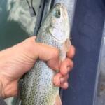
Camp Far West is highly regarded among tournament anglers as a high-volume numbers factory for aggressive Spotted Bass, complemented by a healthy kicker population of Largemouth Bass. Right now, the bass are locked into a quintessential summer pattern. The hyper-aggressive Spots are pushing baitfish into the shallow coves under the cover of darkness, while the larger, wiser females are suspending over intermediate depths and main-lake points to recover and feed during peak solunar windows. Their metabolism is peaking, making them highly susceptible to reaction strikes early in the day before retreating to the safety of deep structure.
Sleeper Pick: Channel Catfish
While the bass boats crowd the points at dawn, night anglers and shore fishermen are quietly putting together heavy stringers of Channel Catfish. The steep rocky banks near the dam and the muddy flats in the upper Bear River arm become prime hunting grounds for whiskerfish once the sun goes down and the boat wakes subside. Many anglers overlook this robust fishery, focusing entirely on the black bass, which leaves the catfish population relatively unpressured and willing to bite.
Baitfish Report: Threadfin Shad
The entire predatory ecosystem of Camp Far West revolves around Threadfin Shad. The summer shad schools are currently tightly balled up and moving along hard structures. You will see them flickering and dimpling on the surface at dawn as they are corralled by aggressive Spotted Bass. Matching this hatch with appropriately sized, slender profiles and translucent or reflective colors is the absolute key to unlocking the lake's potential right now.
3. TACTICAL STRATEGY
To consistently put fish in the boat during the dog days of summer, you need to be surgical with your timing and presentation. The fish are heavily pressured and highly conditioned to standard presentations, so refining your approach is critical.
Where: Focus your efforts on the steep rock bluff walls and transition banks in the lower main lake, or the submerged timber in the Bear River arm. Target the 15 to 25-foot depth range where the shallow flats drop off into the old river channel. The fish are using these steep breaks to move vertically in the water column as the sun rises, allowing them to ambush prey without expending unnecessary energy.
Lure: Start the morning with a topwater walking bait, such as a Zara Spook or a River2Sea Rover in bone or clear, working it parallel to the bank. As the sun hits the water and pushes the fish deeper, switch to a 1/8oz tungsten Ned rig or a 3-inch Yamamoto Scope Shad on a 1/4oz ball-head jig for mid-strolling through suspended schools.
Color: For plastics, translucent shad patterns like Electric Shad excel in the clearer main lake water. If you are dragging the bottom, Blue Craw or Green Pumpkin with red flake perfectly mimics the local crawdads hiding in the shale and chunk rock.
Bait: For the sleeper catfish bite, thread a chunk of cut anchovy, mackerel, or chicken liver onto a 2/0 circle hook on a sliding sinker rig. Fish this on the muddy flats in the upper river arms after dark, utilizing a 1-ounce egg sinker to keep the bait pinned to the bottom.
Timing: The golden window is from first light until 9:00 AM. Once the sun clears the foothills and the recreational boaters launch, the topwater bite dies and the fish retreat to deeper, cooler water. Late evening and night fishing are your best bets for avoiding the crowds and finding active fish.
Pro Tip: When fishing the Ned rig on those 15 to 25-foot drop-offs, less is more. Resist the urge to aggressively hop the bait. Instead, drag it slowly across the shale and employ long pauses (dead-sticking). The strikes will often feel like a subtle heaviness or a slight tick on the slack line. Let the natural water movement do the work for you.
Pro Tip: Pay close attention to the wind. A light morning ripple on the water breaks up the surface tension and extends the topwater bite by masking your presentation and making the fish less cautious. If you find a wind-blown point with shad flickering on the surface, camp out there—it will hold feeding fish much later into the morning than calm, protected coves.
4. REGULATIONS SNAPSHOT
Always consult the latest California Department of Fish and Wildlife (CDFW) regulations before hitting the water, but here is the current snapshot for Camp Far West Reservoir:
Species
Size Limit
Bag Limit
Season Status
Black Bass (Largemouth, Spotted, Smallmouth)
12 inches minimum
5 fish in combination
Open Year-Round
Channel Catfish
No size limit
10 fish
Open Year-Round
Sunfish/Bluegill
No size limit
No limit
Open Year-Round
Health Advisory Note: Due to historical gold mining in the Bear River watershed, the Office of Environmental Health Hazard Assessment (OEHHA) has issued specific consumption advisories for Camp Far West Reservoir regarding elevated mercury levels, particularly in Spotted Bass and Largemouth Bass. It is highly recommended to practice catch-and-release for larger predatory fish to ensure your safety and the health of the fishery.
5. REGIONAL ALTERNATIVE
If you arrive at Camp Far West and find the boat traffic too dangerous, the water levels unmanageable, or the wind howling down the main river channel, pack up your gear and head roughly 30 minutes north to Englebright Lake.
Englebright is a steep, narrow, river-run reservoir on the Yuba River that also boasts an incredible Spotted Bass population. More importantly for summer anglers, Englebright enforces strict speed limits on much of the lake, completely eliminating the jet ski and wakeboard traffic that plagues Camp Far West during the warmer months. Launch at the Skippers Cove Marina area and target the sheer
rock walls and deep drop-offs with finesse plastics like drop-shots and dart heads. The cooler water coming from New Bullards Bar upstream keeps the bass active throughout the day, offering a much more peaceful and consistent daytime fishing experience.
6. WEATHER & CONDITIONS
Expect classic Northern California summer weather for the foreseeable future. Morning lows will hover comfortably in the mid-60s, but temperatures will rapidly climb into the upper 90s or low 100s by mid-afternoon. Winds are generally light and variable at dawn, providing glassy surface conditions perfect for topwater, before picking up to 10-15 mph from the south/southwest in the afternoon. Water clarity remains fair to good (4-8 feet of visibility) in the main lake body, though the upper river arms are becoming heavily stained due to the continuous summer drawdowns.
7. LOCAL RESOURCES
For last-minute tackle needs, live bait, and up-to-date lake conditions, make sure to stock up in nearby Lincoln or Marysville before heading up the hill, as immediate lakeside amenities are limited. Always verify the status of the North and South Shore launch ramps, as dropping water levels can occasionally render certain lanes unusable. Ensure your boat registration and Quagga mussel inspection stickers are completely up to date before launching.
Tight lines!
Editor's Choice: Must-Have Gear
FISHINGSIR Next-Gen Waterproof Chest Waders
★★★★★4.4 (7,370+ reviews)
2-Ply Tech: Upgraded nylon with 2.5x higher density than standard fabrics.
100% Waterproof: Lab-approved intrusion resistance with taped visible seams.
Ultra-Lightweight: Designed for all-day comfort while hunting or fishing.
As an Amazon Associate I earn from qualifying purchases. #ad
Loading forecast...
Live Fishing Conditions: Tides, Weather & Waves
Get real‑time tides, marine weather, swell and solunar activity for each spot so you know exactly when conditions line up for your best chance at a bite.
🎣
Cam Far West Reservoir
Loading coordinates...
🌤️
WEATHER CONDITIONS
--°F
--°C
Loading...
🌡️
Feels Like--°F--°C
💧
Humidity--%
💨
Wind-- mph-- km/h
🧭
Direction--
📊
Pressure-- inHg-- hPa
☀️
UV Index--
🌊
MARINE CONDITIONS
🌊Wave Height
-- ft
-- m
Loading...
🧭Wave Direction
--°
Loading...
⏱️Wave Period
-- s
Loading...
📈Tide Status
-- ft
-- m
Loading...
🌙
LUNAR & SOLUNAR
🌕
Loading...
Illumination: --%
Major Period--:-- - --:----:-- - --:--
Minor Period--:-- - --:----:-- - --:--
🌅Sunrise--:--
🌇Sunset--:--
📅
24-HOUR FORECAST
Loading fishing conditions...
Fishing Spots Map
🎣
Book a Fishing Charter near Cam Far West Reservoir Fishing Report Today 🎣
Local guides & charters. Verified captains, instant booking, best price guaranteed.
There was an error loading the map. Please try refreshing the page.
Info
Local Access & Facilities
Situated in the semi-arid high desert of Colorado, Cam Far West Reservoir—known widely to locals and the state as the heart of Pueblo Reservoir—represents a distinct oasis for serious anglers navigating the Fryingpan-Arkansas Project. This fishery is defined by its dramatic contrast: deep, cool waters held back by the massive Pueblo Dam against a backdrop of limestone bluffs and shale ridges. For the expert angler, this is not merely a place to cast a line; it is a complex hydrological environment covering 4,646 surface acres with over 64 miles of shoreline that demands a strategic approach to bottom topography and wind patterns.
The atmosphere here is rugged yet accessible, sitting at an average elevation of 5,000 feet. Unlike the high-alpine lakes that remain frozen well into spring, this water offers a longer open-water season, making it a critical target for those chasing warm water species in the shoulder seasons. The reservoir is renowned for its diversity, holding significant populations of Walleye, Smallmouth Bass, and Largemouth Bass. It holds a place in history as the site where the Colorado state record Spotted Bass was landed in 1994, a fact that continues to draw tournament pros looking to exploit the rocky points and submerged structure that define the lake's character.
For the seasoned captain, the allure here is the variety of tactical options. You can troll deep channels for Walleye, pitch jigs against the steep canyon walls for Smallmouth, or work the shallower coves for Crappie and Northern Pike. The water clarity and temperature fluctuations, driven by the Arkansas River inflow, create a dynamic fishery where conditions can shift rapidly. Understanding the layout of the state park and the specific logistical realities of the boat ramps and support facilities is the first step to a successful campaign on these waters.
Access & Getting There
Reaching Cam Far West Reservoir requires navigating through Pueblo West, a route that is generally trailer-friendly but can see increased traffic volumes during peak summer weekends. Most anglers approaching from the north or south will utilize I-25, exiting onto US 50 westbound for approximately four miles. From there, the route turns south on Pueblo Blvd and then west onto Thatcher Ave, which leads directly into the park boundaries. The roads are paved and wide enough to accommodate heavy fiberglass boats and dual-axle trailers, but drivers should remain alert for wildlife, particularly deer, which are prevalent in the wildlife lands surrounding the reservoir.
💡 Captain's Tip: Wind Awareness
At 5,000 feet in a high-desert canyon, wind is your primary logistical enemy. The afternoon winds often whip down the Arkansas River valley, turning the main basin into a washing machine. Seasoned skippers launch early—often before dawn—and plan to be off the main open water or tucked into a leeward cove by 1:00 PM when the gusts typically peak.
The primary launch facilities are robust, designed to handle the 1.7 million annual visitors the park receives. There are two major boat ramps located on the reservoir, generally referred to as the North Shore and South Shore ramps. These ramps are concrete, multi-lane structures capable of handling substantial fishing vessels. However, during low water years—a common reality in the arid West—ramp availability can change. It is imperative to check current water levels before towing, as the distance from the parking lot to the water's edge can increase significantly during drawdown periods, complicating the launch process for solo anglers.
Parking at the launch sites is ample but fills rapidly during the summer season. The lots are designed with pull-through spaces for trailers, but the sheer volume of recreational boaters (wake boats and jet skis) can make maneuvering tight by mid-morning. For those fishing from the bank or launching kayaks, the Valco Ponds area offers a specialized parking lot roughly 3.3 miles from the main reservoir spots, providing a quieter alternative to the main marina hustle. Security patrols are present, but standard precautions regarding gear left in truck beds should always be observed.
Weather contingencies are a critical part of access planning here. The semi-arid climate means that while rain is infrequent, thunderstorms can be violent and sudden. The road surfaces can become slick with oil residue during the first few minutes of rain. Furthermore, while the park remains open year-round, winter access changes the dynamic significantly. The boat ramps generally remain accessible, but the support facilities, including fish cleaning stations and comfort stations, are often winterized and locked. Anglers targeting winter trout or walleye must be self-sufficient.
Cam Far West Reservoir Pre-Trip Checklist
Facilities & Amenities
The infrastructure surrounding Cam Far West Reservoir is well-developed, catering to both the casual weekender and the serious sportfishing enthusiast. The park itself hosts two full-service marina complexes, which is a luxury compared to many western reservoirs. These marinas provide slip rentals, fuel, and basic marine supplies, allowing captains to stay on the water longer without needing to haul out for refueling. However, seasoned anglers know that marina fuel prices carry a premium, so topping off at a station in Pueblo West before entering the park is the standard operating procedure for the budget-conscious.
When it comes to tackle and bait, the local ecosystem of shops is specialized. The Drift Fly Shop, located about 7.5 miles from the water on US-50, is the premier destination for those targeting trout or looking for high-quality terminal tackle. They open at 8:30 AM, which is late for the dawn patrol crowd, so planning ahead is necessary. For live bait and more general conventional gear, NicQwik on W Northern Ave serves as a reliable stop, open until 10:00 PM, making it a viable option for picking up nightcrawlers or ice the night before a trip. A unique local resource is TankMatez, though anglers should verify their specific stock for game fishing versus aquarium needs before relying on them for trip essentials.
💡 Captain's Tip: Winter Logistics
While the fishery is open year-round, the creature comforts are not. The state park facilities, including water spigots and flush toilets at the ramps, are closed during winter months. If you are planning a cold-water Walleye trip in January, bring your own freshwater and ensure your trailer bearings are prepped for cold-water submersion.
Lodging and overnighting logistics are a major strength of this location. The Lake Pueblo State Park offers immediate access through campgrounds like Yucca Flats. These sites are highly coveted because they allow you to sleep within minutes of the boat ramp, maximizing fishing time. Yucca Flats offers electrical hookups, which is essential for charging trolling motor batteries overnight. For those seeking a more rugged or historic experience away from the main lake noise, Davenport Campground and Mingus Ranch offer alternatives, though they are located over 20 miles away in the San Carlos Ranger District. These sites are better suited for anglers who are combining a fishing trip with a mountain retreat rather than those focused solely on maximizing hours on the water.
It is important to note the "negative knowledge" for this area: there are no boat repair shops directly on the water. If you spin a hub or blow a fuse, you will likely need to trail back into Pueblo or Canon City for service. Additionally, while there are fish cleaning stations mentioned in the general park descriptions, experienced locals often bring their own coolers and clean fish at home, as the public stations can become crowded or may be shut down for maintenance without widespread notice.
Permits, Regulations & Fees
Navigating the regulatory environment of Cam Far West Reservoir is critical for legal operation. This body of water is a State Park Fee Area, meaning a valid Parks Pass is required for every vehicle entering the grounds, in addition to any camping fees. This is separate from your fishing license. The management is overseen by Colorado Parks and Wildlife (CPW), and their rangers are active and present. They enforce not only catch limits but also boating safety regulations and, crucially, Aquatic Nuisance Species (ANS) protocols.
The ANS inspections are arguably the most significant regulatory hurdle for boaters in Colorado. Before launching, your vessel must undergo a mandatory inspection for zebra and quagga mussels. This is not a suggestion; it is a legal requirement. Boaters arriving from out of state or from other bodies of water should expect a thorough examination of their hull, livewells, and trailer. To expedite this process, ensure your boat is clean, drained, and dry before arrival. Arriving with standing water in your bilge or livewell can result in a denied launch and a mandatory decontamination period, ruining a planned trip.
Fishing regulations here generally follow statewide limits, but site-specific rules often apply to Bass and Walleye sizes to manage the trophy potential of the fishery. Anglers should consult the current season's brochure available at the Recreation Information Center or the entry gate. Cultural respect is also paramount; the reservoir borders wildlife lands and areas of historical significance. Accessing private property or restricted dam areas is strictly prohibited and heavily fined. The "Kapu" concept of stewardship, while Hawaiian in origin, applies here in the form of "Leave No Trace" principles, especially given the high visitor volume and the fragile high-desert ecosystem.
Events & Seasonal Information
The biological and recreational rhythms of the reservoir are dictated by the seasons. Spring is often the most dynamic time for anglers, as the water warms and species like Walleye and Bass move into shallower water to spawn. This is also when tournament pressure is highest. Several regional bass clubs and walleye circuits hold events here, often filling the parking lots by 5:00 AM. If you are not fishing a tournament, it is wise to check the event calendar to avoid days when hundreds of boats are competing for the same points.
Summer brings the recreational boating crowd. By mid-June, the water temperature rises, and the jet skis and wake boats dominate the main basins from late morning to evening. Serious anglers adjust to this by shifting to a nocturnal or dawn-patrol schedule. Night fishing for Catfish and Walleye is a popular and productive tactic during the heat of July and August, allowing you to avoid both the intense sun and the recreational boat traffic.
Fall sees a return to tranquility as the recreational traffic dies down. The cooling water triggers a feeding frenzy for Bass and Wiper (Hybrid Striped Bass), making it a favorite season for fly fishermen and light-tackle enthusiasts. Winter fishing is viable for the hardy, but it requires specialized safety gear and an awareness of hypothermia risks. The water levels also fluctuate seasonally based on agricultural demands downstream, altering the shoreline structure and exposing hazards that were safely submerged months prior.
Facilities Data
Facility Name
Type
Distance from Water
Notes & Specialization
Yucca Flats Campground
Lodging / Camping
1.7 miles
Located inside the State Park. Offers electrical hookups. Ideal for boat owners needing battery charging.
The Drift Fly Shop
Retail / Tackle
7.5 miles
Specializes in fly fishing gear. Opens at 8:30 AM. Located on US-50.
NicQwik
Bait / Supplies
7.4 miles
Convenience store with bait. Open until 10:00 PM. Good for late-night supplies.
Research Drive Storage
Parking / Storage
4.6 miles
Secure storage option nearby. Useful for multi-day trips if campground parking is full.
Mingus Ranch
Lodging / Cabin
23.1 miles
Historic 1908 cabin rental. Rustic experience (no running water). Far from ramp, best for retreats.
Davenport Campground
Camping
22.8 miles
Tent only. Located in Wet Mountains. High elevation (8,500 ft). scenic but distant from launch.
Contact Information & Resources
For immediate inquiries regarding park conditions, ramp status, or camping availability, the primary contact is the Lake Pueblo State Park office at 719-561-9320. They are the authority on daily operations and should be your first call if weather looks questionable. For issues regarding the distant campgrounds like Davenport or Mingus Ranch, contact the San Carlos Ranger District at 719-269-8500.
Safety on this water is a matter of self-reliance. Cell phone coverage is generally good near the main marina and dam but can be spotty in the deep western coves or up the river arms. Always file a float plan with someone on shore. In the event of an emergency, 911 is the standard protocol, but response times can vary depending on your location on the water. Be aware that the high-desert environment accelerates dehydration; carry more water than you think you need.
For precise locations of the boat ramps, real-time weather data, and detailed maps of the surrounding amenities, consult the live dashboard and interactive maps below.
Our spot reports combine data-driven forecasts with curated local information. The forecast is generated by our proprietary Fishing Score algorithm (0–100%), which analyzes real-time data from Open-Meteo API, validated against NOAA CO-OPS tide gauges and USGS water-monitoring stations. The model weights tide dynamics (35%), wave energy (25%), wind patterns (20%) and time of day (20%)—factors shown to influence fish feeding behavior through marine-biology research and decades of charter log data.
Access, facilities and services information for each fishing spot is sourced from official datasets such as Recreation.gov (RIDB), state park & wildlife agencies, and geospatial providers like Google Maps. These sections undergo scheduled re-validation every 3–6 months to ensure that boat ramps, park access, contact details and local services remain accurate.
Narrative sections (catches, seasonal behavior, local tips) are synthesized from these data sources and refined following the Fishing Reports Today editorial guidelines, combining bibliographic research from ichthyology and oceanography with expert angler experience. Our team reviews reports on a regular basis, while the forecast model itself updates every 6 hours for real-time accuracy.
⚠️ Important: Always verify current local regulations, access restrictions and weather conditions before fishing. These reports are intended as a planning aid, not a guarantee of catches or safety. When in doubt, contact local authorities or park managers listed on the page.
To provide the best experiences, we use technologies like cookies to store and/or access device information. Consenting to these technologies will allow us to process data such as browsing behavior or unique IDs on this site. Not consenting or withdrawing consent, may adversely affect certain features and functions.
Functional Always active
The technical storage or access is strictly necessary for the legitimate purpose of enabling the use of a specific service explicitly requested by the subscriber or user, or for the sole purpose of carrying out the transmission of a communication over an electronic communications network.
Preferences
The technical storage or access is necessary for the legitimate purpose of storing preferences that are not requested by the subscriber or user.
Statistics
The technical storage or access that is used exclusively for statistical purposes.The technical storage or access that is used exclusively for anonymous statistical purposes. Without a subpoena, voluntary compliance on the part of your Internet Service Provider, or additional records from a third party, information stored or retrieved for this purpose alone cannot usually be used to identify you.
Marketing & Affiliates
The technical storage or access is required to create user profiles to send advertising, or to track the user on a website or across several websites for similar marketing purposes, including affiliate tracking for products recommended in our reports.


Leave a Reply