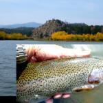
Welcome to the comprehensive summer briefing for the Cache la Poudre River. As Colorado's only federally designated Wild and Scenic River, the Poudre offers a masterclass in freestone canyon fishing. Flowing out of the high peaks of the Front Range down through Roosevelt National Forest, this river demands technical proficiency, adaptability, and a strong understanding of its diverse micro-habitats. Below is your definitive guide to dissecting the Poudre's currents and maximizing your time on the water during the summer season.
1. GO/NO-GO STATUS
The Cache la Poudre River is currently navigating the dynamic transition of summer, characterized by building snowmelt from the high country and fluctuating daily flows. As the snowpack releases, the river transitions from a lean, easily wadeable freestone into a heavier, pushier waterway. Anglers need to be prepared for changing conditions on a day-to-day basis.
Safety is a primary consideration during this seasonal window. Wading in the canyon sections along Highway 14 can become treacherous as the cubic feet per second (CFS) rises. Pocket water that was easily navigable weeks ago now features heavy seams and powerful hydraulics. Additionally, this is a major recreation corridor, so expect heavy raft, kayak, and tubing traffic as the ambient air temperature warms up. Weather patterns in the canyon can shift rapidly, with afternoon thunderstorms bringing sudden, localized spikes in water levels and turbidity.
🎣Nautrek
Private Beta
J
M
R
100+ anglers on the waitlist
The fishing network where your reputation matters.
Find trusted captains, join real trips with cost splitting, and build your Angler Rank. Your spots stay private — you decide who sees your intel.
This is not a blanket "No-Go," but rather a strong advisory to fish smart. The edges, slower seams, and deep pockets behind major boulders are holding active fish, but you must respect the current, avoid aggressive wading, and time your session to beat the runoff surges.
2. SPECIES INTEL
Primary Target: Brown and Rainbow Trout
The Cache la Poudre is a legendary wild trout fishery, heavily dominated by aggressive Brown Trout and a rapidly rebounding population of Rainbow Trout. Following extensive and ongoing efforts by Colorado Parks and Wildlife (CPW) to stock whirling-disease-resistant Rainbows, we are seeing a fantastic resurgence of these acrobatic fish in the canyon. Based on recent planting cycles, many of these Rainbows are now pushing the 12 to 14-inch mark, with older holdovers exceeding 16 inches. The Browns are actively holding in the undercut banks and darker, slower pools, while the Rainbows are increasingly found feeding in the faster riffles and oxygenated seams.
Sleeper Pick: North Fork Yellow Perch
While the main stem of the Poudre is a trout purist's dream, the North Fork—specifically the stretches and connected ponds near the Gateway Natural Area—holds a surprisingly robust population of Yellow Perch and Crappie. Most anglers drive right past these waters hunting for trout, leaving these panfish completely unpressured. They school up tightly near submerged vegetation and offer fantastic, fast-paced action when the main river is too blown out to fish effectively.
Pro Tip:When targeting the Yellow Perch in the lower North Fork ponds, downsize your gear dramatically. A 1/32oz micro-jig tipped with a tiny piece of an aquatic worm imitation under a slip bobber will out-fish traditional trout gear ten to one.
Baitfish & Forage Report
The river's biomass is incredibly diverse right now. The primary baitfish driving the predatory instincts of larger Brown Trout are Mottled Sculpins. These bottom-dwellers are abundant in the rocky substrates. On the invertebrate front, the summer menu is transitioning beautifully. We are seeing strong emergences of Pale Morning Duns (PMDs), robust Yellow Sally stoneflies, and the ever-reliable caddisflies in the evenings. Aquatic worms are also a major food source, particularly after an afternoon rain shower washes sediment into the system.
3. TACTICAL STRATEGY
Where to Deploy
To find success in current conditions, you must treat the Poudre as a series of connected micro-habitats rather than a uniform river. Avoid the heavy, main-channel currents. Instead, focus your efforts on the Wild Trout Water section starting at the Pingree Park Bridge and working upstream toward Rustic along Highway 14. Look for the "soft water"—the foam lines, eddies, and tailouts behind large granite boulders in 3 to 5 feet of water. Another high-percentage zone is the North Fork confluence near Gateway Natural Area, where the mixing currents create a natural 4-foot-deep feeding lane for educated trout.
Pro Tip:When fishing the pocket water of the Poudre, keep your casts short and your rod tip high. "High-sticking" allows you to keep your fly line off the conflicting surface currents, ensuring a drag-free drift through the strike zone.
Lure & Fly Selection
For the fly angler, a dry-dropper rig is the most efficient way to prospect the pocket water. Start with a buoyant, highly visible dry fly like a #14 Elk Hair Caddis or a #10 Fat Albert to mimic early terrestrial activity and suspend your nymph. For the dropper, run 18 to 24 inches of 5X fluorocarbon to a #18 Juju Baetis, a #16 Frenchie, or a #12 Pink San Juan Worm.
If you are targeting trophy Browns, strip a heavily weighted streamer through the deeper pools. A #4 Black Matuka or an Olive Articulated Sculpin will trigger aggressive reaction strikes when stripped erratically through the tailouts.
For spin anglers fishing the designated lure-friendly zones, swap out the standard hardware for a 1/16oz Panther Martin in Black/Gold, or a 1/8oz Kastmaster in Silver/Blue. Single, barbless hooks are highly recommended to reduce fish mortality.
Colors & Presentation
Water clarity will dictate your color palette. In the early morning when the water is running clear, stick to natural tones: olive, brown, and subtle grays. As the snowmelt increases throughout the afternoon, introducing a slight stain to the water, pivot to flies and lures with a touch of flash or fluorescent hot spots (like a pink bead or a chartreuse collar) to help the fish locate your presentation.
Bait Restrictions
It is critical to note that the most productive stretches of the Cache la Poudre are strictly managed as artificial flies and lures only. The use of live bait, cut bait, or scented artificial baits is strictly prohibited in these zones. Always verify the specific regulations for the mile marker you are parked at.
Timing the Bite
Right now, the clock is your most important piece of gear. The optimal feeding window opens at first light and generally runs until 10:30 AM. During this period, water temperatures are stable, clarity is at its peak, and the recreational tubing and rafting traffic is minimal. A secondary window opens in the late evening, offering explosive dry fly action during the caddis hatch, provided the afternoon runoff hasn't severely muddied the water.
Pro Tip:Watch the bubble lines. Wherever you see a line of foam and bubbles drifting down a seam, that is a natural conveyor belt of insect life. Drop your rig right into the bubbles and let the current do the work.
4. REGULATIONS SNAPSHOT
The Cache la Poudre River features complex, section-by-section management to protect its wild trout populations. Below is a snapshot of the critical regulations you must know before wetting a line.
River Section
Tackle Restrictions
Bag & Size Limits
Gateway Park to North Fork Confluence
Artificial Flies & Lures ONLY
Catch and Release ONLY (All Trout)
Pingree Park Bridge to Hombre Ranch
Artificial Flies & Lures ONLY
Catch and Release ONLY (All Trout)
RMNP Boundary to Joe Wright Creek
Artificial Flies & Lures ONLY
2 Trout Limit
North Fork (Seaman Reservoir downstream)
Artificial Flies & Lures ONLY
Catch and Release ONLY (All Trout)
Always handle fish with wet hands, keep them in the water as much as possible, and use barbless hooks to facilitate a quick, harmless release. A valid Colorado fishing license is required for all anglers aged 16 and older.
5. REGIONAL ALTERNATIVE
If the Poudre blows out due to a heavy afternoon thunderstorm or a massive spike in snowmelt, do not pack up and head home. Your premier regional fallback is the Big Thompson River, located just a short drive south near Estes Park.
The Big Thompson is a classic tailwater fishery below Lake Estes, meaning its flows are dam-controlled and far more stable during the turbulent summer runoff season. Access is phenomenal along Highway 34. The target species here remain Brown and Rainbow Trout, but the tactical approach requires more finesse. The fish in the Big Thompson see a lot of pressure and can be incredibly selective. Downsize your tippet to 6X and deploy technical midge and baetis patterns, such as a #20 Top Secret Midge or a #22 Zebra Midge. Focus your efforts on the deeper runs and the tail-outs of the major pools. The Big Thompson provides a reliable, clear-water sanctuary when the free-flowing freestone rivers are raging.
Tight lines!
Editor's Choice: Must-Have Gear
FISHINGSIR Next-Gen Waterproof Chest Waders
★★★★★4.4 (7,370+ reviews)
2-Ply Tech: Upgraded nylon with 2.5x higher density than standard fabrics.
100% Waterproof: Lab-approved intrusion resistance with taped visible seams.
Ultra-Lightweight: Designed for all-day comfort while hunting or fishing.
As an Amazon Associate I earn from qualifying purchases. #ad
Loading forecast...
Live Fishing Conditions: Tides, Weather & Waves
Get real‑time tides, marine weather, swell and solunar activity for each spot so you know exactly when conditions line up for your best chance at a bite.
🎣
Cache La Poudre
Loading coordinates...
🌤️
WEATHER CONDITIONS
--°F
--°C
Loading...
🌡️
Feels Like--°F--°C
💧
Humidity--%
💨
Wind-- mph-- km/h
🧭
Direction--
📊
Pressure-- inHg-- hPa
☀️
UV Index--
🌊
MARINE CONDITIONS
🌊Wave Height
-- ft
-- m
Loading...
🧭Wave Direction
--°
Loading...
⏱️Wave Period
-- s
Loading...
📈Tide Status
-- ft
-- m
Loading...
🌙
LUNAR & SOLUNAR
🌕
Loading...
Illumination: --%
Major Period--:-- - --:----:-- - --:--
Minor Period--:-- - --:----:-- - --:--
🌅Sunrise--:--
🌇Sunset--:--
📅
24-HOUR FORECAST
Loading fishing conditions...
Fishing Spots Map
🎣
Book a Fishing Charter near Cache La Poudre Fishing Report Today 🎣
Local guides & charters. Verified captains, instant booking, best price guaranteed.
There was an error loading the map. Please try refreshing the page.
Info
Local Access & Facilities
The Cache la Poudre River corridor, pushing northwest from the plains of Laporte and Fort Collins, offers one of the most dynamic freshwater fisheries in Colorado. Designated as the state's first National Wild and Scenic River, the Poudre carves through steep mountains, dense Ponderosa pines, and shimmering aspen groves. For the seasoned angler, this region presents a rugged, high-altitude arena defined by fast-moving pocket water and deep, dark pools. The atmosphere here is wild and untamed, demanding technical wading skills and precise casting.
While the river itself is a haven for purists targeting brown, cutthroat, and rainbow trout, the surrounding watershed offers serious diversity. Just minutes away, the sprawling expanse of Horsetooth Reservoir provides a completely different theater of operations. This massive impoundment caters to the heavy-tackle and boat-based crowd, holding aggressive smallmouth bass, wiper, and deep-dwelling walleye. Whether you are throwing dry flies in a secluded canyon or trolling deep structure in the reservoir, the local topography dictates your tactical approach.
Expert anglers know that mastering the Laporte and Fort Collins area requires understanding the distinct rhythms of both moving and still water. The transition from the manicured, urban staging grounds of Fort Collins to the black lava-like rock formations of the upper canyon happens rapidly. Success here relies heavily on logistical preparation, knowing exactly where to launch, and understanding how the seasonal weather patterns impact the watershed.
Access & Getting There
Navigating to the prime fishing grounds requires a dual strategy depending on your target water. For river access, Highway 14 is your primary artery, winding directly along the Cache la Poudre North Park Scenic Byway. Traffic moving up the canyon can bottleneck during peak summer weekends, largely due to the influx of whitewater rafting outfitters. Seasoned skippers know to push up the canyon well before dawn to secure premium pull-offs near Ansel Watrous or Stove Prairie before the recreational crowds arrive.
If you are hauling a vessel to Horsetooth Reservoir, the logistics shift toward managing steep grades and busy ramps. The reservoir features seven distinct boat-launch ramps spread across its 6.5 miles of length. The ramps are generally wide and well-maintained, but they can become incredibly slick during periods of low water or after heavy rains. Trailer parking is widely available at the primary ramps, but these lots frequently reach capacity by early morning during the summer peak.
Weather contingencies are critical when planning your access strategy in this high-elevation environment. When high winds funnel through the foothills, the open waters of Horsetooth Reservoir can become dangerously choppy, making the leeward ramps near Inlet Bay your safest bet for launching. Conversely, if sudden canyon thunderstorms blow out the upper Poudre River, turning the water muddy, anglers often pivot to the reservoir or head south toward Flatiron Reservoir for clearer conditions.
💡 Captain's Tip: Navigating the Horsetooth Drawdown
Reclamation projects and dam modernizations occasionally lower the water levels at Horsetooth Reservoir significantly. Always check current reservoir levels before hauling a heavy boat up the grade, as low water can render some of the secondary boat ramps unusable for larger vessels.
For shore-based anglers hitting the lower river stretches, parking strategy is heavily reliant on designated access points. The Shields Street River Access provides excellent, well-maintained parking close to the urban boundary. Further up into the foothills, anglers must rely on tight, gravel pull-outs. Always ensure your vehicle is completely off the asphalt of Highway 14, as local law enforcement strictly monitors the canyon for traffic hazards.
Cache La Poudre Pre-Trip Checklist
Facilities & Amenities
The infrastructure supporting the Cache la Poudre fishery is heavily concentrated in Fort Collins, functioning as the ultimate basecamp before ascending into the canyon. The local tackle scene is highly specialized toward fly fishing. Mountain Fly Shop operates as the premier Orvis-authorized dealer, providing high-end gear and hyper-local intel on current hatches. Meanwhile, St. Peter's Fly Shop - South is a vital hub for tying materials and expert advice on traversing the upper canyon waters.
For those targeting the reservoir species with heavy conventional gear, the immediate canyon area lacks specialized big-tackle outfitters. Anglers looking for heavy-duty trolling gear or specialized walleye rigs often need to source their equipment before leaving the highway corridors. Vancestackle, located roughly 23.9 miles away in Berthoud, is a reliable option for conventional tackle if you are willing to make the drive prior to your dawn patrol.
Lodging logistics dictate how early you can hit the water. For those wanting to sleep right on the river, the Ansel Watrous and Stove Prairie campgrounds offer excellent access. These sites feature gravel driveways capable of handling trailers up to 40 feet, complete with tent pads and fire rings. However, negative knowledge is vital here: neither campground offers electrical hookups, and you must haul in your own drinking water or rely on the basic vault toilets provided.
💡 Captain's Tip: Urban Staging for Canyon Starts
If you prefer a comfortable bed over a tent, The Armstrong Hotel in Fort Collins operates 24 hours a day. It is perfectly positioned for a 4:00 AM departure, allowing you to grab coffee and hit the canyon access points before the sun hits the water.
Below is a breakdown of the critical facilities and staging areas utilized by local experts.
Facility Name
Type
Distance
Key Feature
Mountain Fly Shop
Tackle & Gear
6.7 miles
Orvis Authorized Dealer
St. Peter's Fly Shop
Tackle & Gear
11.3 miles
Premium Fly Materials
Ansel Watrous
Campground
9.9 miles
Direct River Access
Stove Prairie
Campground
12.2 miles
40-Foot Trailer Capacity
Shields Street
Parking
5.1 miles
Lower River Access
The Armstrong Hotel
Lodging
6.8 miles
24-Hour Operations
Permits, Regulations & Fees
Fishing the Cache la Poudre and surrounding reservoirs requires strict adherence to the rules set forth by the State Fishing Agency. The regulations here are not just bureaucratic red tape; they are essential for preserving the delicate balance of a high-altitude, Wild and Scenic watershed. The native cutthroat and brown trout populations face intense pressure during the summer, making catch-and-release practices and barbless hook regulations common in specific upper stretches of the canyon.
Accessing the Arapaho & Roosevelt National Forests requires an understanding of federal land use fees. While driving the scenic byway is free, parking at developed recreation sites, day-use areas, and campgrounds generally requires a daily vehicle pass or a valid annual National Parks and Federal Recreational Lands Pass. When utilizing the boat ramps at Horsetooth Reservoir, Larimer County requires specific daily or annual entrance and boat launch permits, which fund the maintenance of the marinas and parking lots.
If you plan to utilize the canyon campgrounds as your base of operations, reservations are strictly managed. Modifications or cancellations for sites like Ansel Watrous incur a $10.00 service fee, and late cancellations carry steeper penalties. The US Forest Service mandates that all equipment, including trailers and RVs, must fit entirely within the designated gravel driveways, which are strictly capped at lengths of 33 to 40 feet depending on the specific site.
💡 Captain's Tip: Firewood and Invasive Species
Never transport firewood from outside the immediate area due to the risk of introducing invasive beetles. Dead and downed wood can be gathered within the forest, or you can purchase approved bundles directly from the campground hosts at Stove Prairie.
Cultural and environmental respect is paramount in this region. The river corridor borders sensitive ecological zones and private property tracts. Anglers must be hyper-aware of high-water marks and property lines to avoid trespassing. Furthermore, the introduction of aquatic nuisance species is a severe threat; all vessels launching at Horsetooth Reservoir are subject to mandatory state boat inspections to prevent the spread of zebra and quagga mussels.
Events & Seasonal Information
The fishing rhythms in the Laporte area are entirely dictated by the dramatic seasonal shifts of the Rocky Mountains. Winter transforms the landscape, bringing heavy snow and thick ice. Facilities like Flatiron Reservoir close completely during the winter months due to inaccessible, ice-choked roads. During this time, the river flows drop significantly, and anglers must downsize their presentations, targeting deep, slow-moving pools where trout hold to conserve energy.
Spring runoff, typically peaking between late May and June, blows out the river with muddy, fast-moving water. This is when seasoned guides pivot their attention entirely to Horsetooth Reservoir. The rising water levels in the reservoir push smallmouth bass into the shallows to spawn, creating explosive early-season action along the rocky shorelines and submerged timber.
Summer is the peak season, but it brings intense logistical challenges. The Cache la Poudre River becomes a highway for commercial whitewater rafting operations. To fish successfully during July and August, the dawn patrol is mandatory. You must be on the water by first light and off the main runs by mid-morning when the rafts begin their descents. Similarly, afternoon thunderstorms roll over the canyon almost daily at 2:00 PM, making early starts critical for both success and safety.
Contact Information & Resources
Self-reliance is the rule when operating in the upper stretches of the canyon, as cell service disappears rapidly once you leave the plains. The primary managing agency for the forest lands is the Canyon Lakes District Office, co-located with the forest headquarters at 2150 Centre Avenue in Fort Collins. They are your best resource for current road closures, fire bans, and trail conditions.
For reservoir conditions, the Larimer County Parks Department manages Horsetooth Reservoir and Flatiron Reservoir. Always verify water levels and ramp statuses directly with the county before hauling a boat. In the event of an emergency on the river, local swift-water rescue teams are dispatched through the county sheriff, but response times in the deep canyon can be lengthy. Always wear appropriate footwear with felt or studded soles for the slick river rocks, and carry comprehensive first-aid and foul-weather gear.
For precise locations and real-time conditions, consult the live dashboard and maps below.
Our spot reports combine data-driven forecasts with curated local information. The forecast is generated by our proprietary Fishing Score algorithm (0–100%), which analyzes real-time data from Open-Meteo API, validated against NOAA CO-OPS tide gauges and USGS water-monitoring stations. The model weights tide dynamics (35%), wave energy (25%), wind patterns (20%) and time of day (20%)—factors shown to influence fish feeding behavior through marine-biology research and decades of charter log data.
Access, facilities and services information for each fishing spot is sourced from official datasets such as Recreation.gov (RIDB), state park & wildlife agencies, and geospatial providers like Google Maps. These sections undergo scheduled re-validation every 3–6 months to ensure that boat ramps, park access, contact details and local services remain accurate.
Narrative sections (catches, seasonal behavior, local tips) are synthesized from these data sources and refined following the Fishing Reports Today editorial guidelines, combining bibliographic research from ichthyology and oceanography with expert angler experience. Our team reviews reports on a regular basis, while the forecast model itself updates every 6 hours for real-time accuracy.
⚠️ Important: Always verify current local regulations, access restrictions and weather conditions before fishing. These reports are intended as a planning aid, not a guarantee of catches or safety. When in doubt, contact local authorities or park managers listed on the page.
To provide the best experiences, we use technologies like cookies to store and/or access device information. Consenting to these technologies will allow us to process data such as browsing behavior or unique IDs on this site. Not consenting or withdrawing consent, may adversely affect certain features and functions.
Functional Always active
The technical storage or access is strictly necessary for the legitimate purpose of enabling the use of a specific service explicitly requested by the subscriber or user, or for the sole purpose of carrying out the transmission of a communication over an electronic communications network.
Preferences
The technical storage or access is necessary for the legitimate purpose of storing preferences that are not requested by the subscriber or user.
Statistics
The technical storage or access that is used exclusively for statistical purposes.The technical storage or access that is used exclusively for anonymous statistical purposes. Without a subpoena, voluntary compliance on the part of your Internet Service Provider, or additional records from a third party, information stored or retrieved for this purpose alone cannot usually be used to identify you.
Marketing & Affiliates
The technical storage or access is required to create user profiles to send advertising, or to track the user on a website or across several websites for similar marketing purposes, including affiliate tracking for products recommended in our reports.


Leave a Reply