


Overview: A High Desert Oasis for Warm Water Specialists
Situated in the semi-arid high desert plains of Pueblo West, Colorado, this fishery represents a distinct anomaly in a state best known for high-alpine trout streams. While the location data identifies this area near the massive impoundment of the Arkansas River, seasoned anglers recognize the unique topography immediately. This is a water body defined by limestone bluffs, shale shelves, and a surface area spanning over 4,600 acres. Unlike the clear, cold oligotrophic lakes of the high Rockies, this reservoir offers a complex food web that supports a diverse range of warm-water game fish, making it a premier destination for serious bass and walleye anglers.
The environment here is rugged and exposed. The landscape is dominated by piñon-juniper woodlands and red shale cliffs, creating a stark contrast against the blue water. For the expert angler, this topography translates into specific bottom structures: sheer drop-offs, submerged rock piles, and long, tapering points that hold fish during transition periods. The reservoir is part of the Fryingpan-Arkansas Project, created by a massive dam that crosses the Arkansas River. This engineering feat has created a fishery with a maximum depth that challenges even experienced captains to master their sonar, while the 64 miles of shoreline offer endless opportunities for working crankbaits and jigs against structure.
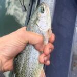
The primary draw for the professional class of anglers here is the "grand slam" potential. While stocked rainbow trout are present, the true trophies are the Smallmouth, Largemouth, and Spotted Bass—the latter of which holds a historic state record caught here in 1994. Furthermore, the Walleye, Wiper, and Channel Catfish populations are robust, requiring a versatile arsenal of techniques. The atmosphere is one of serious recreation; this is a Colorado State Park fee area that attracts heavy boat traffic in summer, meaning the astute angler must understand the rhythms of the "dawn patrol" to secure the best spots before the recreational fleet wakes up.
Access & Getting There
Reaching this fishery requires navigating the high plains infrastructure of Southern Colorado. The primary access corridor is via Interstate 25. For those towing heavy center consoles or bass boats, the route is generally trailer-friendly, but vigilance is required regarding crosswinds on the open highway. From I-25, the standard approach involves heading west on US Highway 50 for approximately four miles, then turning south on Pueblo Boulevard. The final leg involves a six-mile stretch west on Thatcher Avenue, which leads directly into the park boundaries. This route avoids the narrower residential streets of Pueblo West, providing a wider turning radius for larger rigs.
💡 Captain's Tip: Wind Management
The semi-arid desert environment surrounding the reservoir is notorious for sudden, violent wind shifts. Trade winds often kick up by 10:00 AM. When launching, always check the forecast for the "Fetch" direction. If winds are predicted to exceed 15 knots from the west, launch at the North Shore ramp to utilize the bluffs for leeward protection while loading and unloading.
The launch facilities are robust, designed to handle the 1.7 million annual visitors this recreation area attracts. There are two primary boat ramps servicing the reservoir, generally referred to as the North Shore and South Shore marinas. These ramps are concrete, multi-lane facilities capable of handling deep-draft vessels. However, "capable" does not always mean "easy." During peak summer weekends, the queue for the ramp can extend significantly. Experienced captains know to have their vessel prepped in the staging lane—straps off, plugs in, batteries on—before backing down. The ramps can become slick with algae during low-water years, so four-wheel drive is recommended for pulling heavier glass boats out of the water.
Parking is ample but tiered. The primary lots adjacent to the ramps accommodate trailers of substantial length, but they fill rapidly. For those arriving after 8:00 AM on a Saturday, you may be forced to park in overflow lots which can add a significant walk to the dock. Security patrols are present, as this is a managed State Park, but standard precautions regarding gear left in truck beds should apply. For anglers planning extended trips or seeking off-site storage, Research Drive Storage is located roughly 4.6 miles away in Pueblo West, offering a secure perimeter for dropping a trailer if you are staying at a hotel that doesn't permit boat parking.
Winter access presents a different set of challenges. While the reservoir itself remains accessible year-round (a rarity in Colorado), the State Park facilities, including some comfort stations and fish cleaning stations, close during the winter months. The ramps are generally kept open, but ice on the concrete can be treacherous. Anglers targeting the winter Walleye bite should carry sand or kitty litter for traction on the ramp and be prepared for a solitary experience, as the amenities are largely dormant from November through March.
Ridgway Reservoir Pre-Trip Checklist
Facilities & Amenities
The infrastructure surrounding the reservoir is a mix of high-volume public recreation facilities and specialized local businesses. Inside the park boundaries, the amenities are well-maintained by the Colorado Division of Parks and Outdoor Recreation. Anglers will find modern showers and restrooms at the campgrounds, which is a significant luxury after a long day of handling catfish or slime-coated pike. There are fish cleaning stations available during the peak season, though pro anglers often prefer to bleed and ice their catch immediately on the boat rather than waiting in line at the dockside tables.
For tackle and bait, local intelligence is key. The Drift Fly Shop, located about 7.5 miles from the water on US-50, is the premier hub for those targeting the tailwaters below the dam. While their focus is fly fishing, their knowledge of the Arkansas River flows and hatch charts is invaluable for anglers fishing the river section. For conventional gear, live bait, and last-minute supplies, NicQwik on Northern Avenue (7.4 miles away) serves as a reliable stop. It is worth noting that specialized heavy tackle for big wipers or specific bottom-bouncing rigs for walleye might require a trip into the main city of Pueblo, so stocking up on specific terminal tackle before leaving the metro area is advisable.
💡 Captain's Tip: Tailwater Logistics
Don't overlook the water below the dam. The Arkansas River tailwater is a world-class fishery in its own right. If the reservoir is blown out by wind, the river section immediately downstream offers sheltered, high-quality fishing for trout. Parking for this section is available at the Valco Ponds/Goodnight Barn area.
Lodging options vary from primitive to developed. For the angler who wants to be on the water at first light, camping within the park is the most strategic option. Yucca Flats Campground is located just 1.7 miles from the water and offers a rating of 4.7 stars, indicating high-quality maintenance. These sites often include electrical hookups, allowing you to charge trolling motor batteries overnight—a critical necessity for multi-day tournaments. For a more historic and rustic experience, the Mingus Ranch cabin (managed by the Forest Service) offers a step back in time. Located roughly 23 miles away, it provides a solitude that the main campgrounds lack, though it lacks running water, requiring you to pack in your own hydration.
It is critical to note a few "negatives" to save time. While there are marinas, fuel prices on the water are typically at a premium. Smart captains fuel up at the stations along US-50 or Pueblo Blvd before entering the park. Additionally, while there are "2 marina complexes" listed in the data, the availability of specialized marine mechanics on short notice is low. Ensure your outboard is serviced before arrival, as a breakdown here can mean a long tow and a ruined trip. The Davenport Campground, while scenic and historic with its Adirondack shelters, is over 22 miles away; it is not a viable base camp for serious anglers who want to maximize time on the water, but serves as an excellent retreat for a non-fishing rest day.
Permits, Regulations & Fees
Navigating the bureaucracy of this fishery is as important as navigating the channel markers. This is a State Park Fee Area, managed rigorously by Colorado Parks and Wildlife (CPW). A valid Colorado fishing license is the baseline requirement, but access to the water requires a separate vehicle entry pass. Daily passes are available at the gate, but frequent visitors should invest in the annual State Parks pass affixed to the windshield to expedite entry and avoid the queue at the gatehouse during peak hours.
The most critical regulatory hurdle for boaters in this region is the Aquatic Nuisance Species (ANS) Inspection. Colorado is aggressively protective of its waters against zebra and quagga mussels. All trailered vessels are subject to mandatory inspection upon entering the park. You must arrive with your boat Clean, Drained, and Dry. This includes live wells, bilge pumps, and even the lower unit of your motor. Failure to comply can result in a mandatory decontamination wash (which costs time and money) or a complete denial of launch. Experienced captains travel with the drain plug removed and visible to the inspectors to speed up this process.
💡 Captain's Tip: Inspection Efficiency
To breeze through the ANS inspection station, ensure your live well is bone dry and your transom plug is removed before you even pull up to the gate. Keep your receipts from any recent decontamination or inspections at other Colorado lakes, as this paperwork can sometimes expedite the interview process.
Conservation regulations are strictly enforced. The reservoir has specific size and bag limits, particularly for Smallmouth and Largemouth Bass, to protect the trophy potential of the fishery. The "wildlife lands" surrounding the reservoir, comprising approximately 25 square miles of semi-arid desert, are also protected. Off-road driving is strictly prohibited outside of designated areas like the Penrose Commons Recreation Area (located 21.6 miles away). Respect for the land is paramount; this area contains sensitive high-desert vegetation that takes decades to recover from tire tracks. Additionally, be aware of "Kapu" or restricted zones near the dam infrastructure itself, which are marked with buoys for safety and security.
Events & Seasonal Information
The rhythm of this fishery is dictated by the seasons of the high desert. Spring (late April to June) is the prime window for the Walleye spawn and the pre-spawn Bass bite. During this period, the shallow coves and rocky points warm faster than the main lake, concentrating fish in predictable patterns. This is also when the water levels are typically highest, fed by the runoff from the Fryingpan-Arkansas Project. As summer sets in, the water temperature rises, and the fish move to deeper structures. This is when the thermocline becomes the critical variable, and electronics are essential to locate suspended schools of Wiper and Bass.
Tournament season brings a different energy to the water. The reservoir hosts numerous local and regional bass tournaments, typically in the early summer. During these events, the pressure on the primary spots (the dam face, the north shore bluffs) increases exponentially. The savvy recreational angler will avoid tournament weekends or focus on the less-pressured "trash fish" like Carp or Catfish, which grow to immense sizes here but are largely ignored by the tournament fleets.
Fall brings a second peak in activity as fish gorge on shad to prepare for winter. The cooling water temperatures trigger aggressive feeding behaviors, making it an excellent time for throwing topwater lures or jerkbaits. Winter does not shut down the fishery completely, but it shifts the focus. While the park facilities close, the hardcore anglers switch to vertical jigging for deep-water species or, in rare severe winters, ice fishing in the protected coves, though ice conditions here can be inconsistent due to the latitude and sun exposure.
Contact Information & Resources
For the most current information regarding water levels, ramp closures, or emergency alerts, direct communication with the managing agencies is recommended. The Lake Pueblo State Park office can be reached at 719-561-9320. For inquiries regarding the surrounding camping facilities managed by the Forest Service, such as Davenport or Mingus Ranch, contact the San Carlos Ranger District at 719-269-8500. In the event of an on-water emergency, the park rangers patrol regularly, but cell reception can be spotty in the deep canyons; a VHF radio is a prudent safety backup.
For precise locations of the boat ramps, real-time weather conditions, and detailed bathymetry of the nearby spots mentioned, consult the interactive live dashboard and maps below.


Leave a Reply