Welcome to the definitive spring transition fishing intelligence report for Grenada Lake, Mississippi. As a Senior Fishing Editor and professional guide who navigates these legendary waters day in and day out, I can tell you firsthand that this reservoir is a highly complex and dynamic ecosystem. While globally recognized as the undisputed "Home of the 3-Pound Crappie," success here requires constant adaptation. The spring-to-summer transition brings rising water, shifting temperatures, and a massive influx of biological activity that dictates fish behavior. We have synthesized the latest on-the-water observations, bathymetric data, and structural analysis to give you the ultimate tactical advantage. Whether you are spider-rigging the main lake drop-offs or probing flooded timber, this comprehensive report provides the exact, verified intel you need to maximize your time on the water and put more trophy fish in the boat.
GO/NO-GO STATUS
Verdict: GO - WITH CAUTION
Current seasonal conditions on this 35,820-acre flood control reservoir dictate an optimistic but highly prepared approach. We are currently in the thick of the classic post-spawn transition period. Spring rainfall runoff frequently pushes water levels above the standard U.S. Army Corps of Engineers rule curve, resulting in heavily stained to downright muddy water conditions across the majority of the lake.
From the editor
Tired of fishing with strangers you can’t trust?
Nautrek is the first social network for serious anglers — verified partners, real trips, cost splitting and intel sharing without burning your spots. Private beta now open.
Safety Advisory: Ice conditions are entirely inapplicable for Mississippi during this season, but weather impacts are a serious factor. Keep your head on a swivel for heavy floating debris logs that wash down from the river arms during high-water events. Furthermore, monitor the wind forecast meticulously. Grenada's expansive open water can get dangerously rough, especially when sustained winds exceed 15 mph from the west or northwest. If afternoon pop-up thunderstorms threaten, do not hesitate to pull off the water.
SPECIES INTEL
Primary Target: Trophy White Crappie
Grenada Lake is globally recognized as the crappie capital of the world, where fish pushing the 3-pound to 4-pound mark are a legitimate daily possibility. Right now, the legendary "Grenada slabs" have completed their spawn and are transitioning back toward the main river channels. They are hungry, aggressive, and looking to pack on weight to recover from the reproductive cycle.
Sleeper Pick: Largemouth Bass
While 95 percent of anglers on this lake are staring intently at their forward-facing sonar screens for crappie, the largemouth bass bite is exceptionally underrated. As the water warms, bass push shallow to feed heavily on riprap banks and flooded buck brush. They hold incredibly tight to hard cover in the muddy water, making them highly susceptible to reaction strikes.
Baitfish Report: Threadfin and Gizzard Shad
Shad are the undisputed primary forage in this ecosystem. With water temperatures warming, the threadfin shad are actively schooling near secondary points and bridge pilings. Crappie are currently keying in on larger shad profiles. To trigger a strike in low-visibility conditions, you must match the hatch structurally but upsize your presentation to displace more water.
TACTICAL STRATEGY
Where to Fish
Focus your primary efforts on the upper Skuna and Yalobusha River arms. The post-spawn females have moved off the shallow flats and are now suspending 5 to 6 feet deep over 8 to 12 feet of water. Look for stump fields positioned right on the edge of deeper channel bends. The ledges near Graysport Crossing and the submerged timber around Youngs Landing are holding significant schools of staging fish. Additionally, utilize your electronics to locate some of the 3,000 unmarked Christmas tree and cedar top fish shelters placed strategically by the state—these are absolute magnets for transitioning crappie.
Lure Selection
Given the naturally turbid water, your presentation must appeal to a fish's lateral line and sense of smell. Upsize your plastics to bulky profiles that push water. Use a 1/8-ounce to 1/4-ounce tungsten jig head to maintain vertical control in the wind. Soft plastics like the Strike King Mr. Crappie Slabalicious, Slab Slangers, or a 2.5-inch Jenko Mermaid are highly productive right now.
Color Patterns
Contrast is critical. Natural hues will get lost in the muddy runoff. Brightly colored lures that produce flash or vibration work best. Black/Chartreuse, Glowing Orange, and Hot Pink are vastly outperforming natural shad colors.
Bait and Rigging
Spider-rigging is currently the most efficient method for targeting these suspended fish on the ledges. Run double-minnow rigs with heavy egg sinkers (1/2 to 3/4 ounce) to keep your lines perfectly vertical against the current and wind. For single-pole anglers utilizing forward-facing sonar, pitch large, lively shiners directly into the tops of submerged cedar trees or vertical standing timber.
Timing the Bite
The golden window is strictly between dawn and 10:30 AM. As the midday sun penetrates the water, crappie will bury themselves deep into the densest cover available or slide further down the channel drops, making them much harder to trigger.
Pro Tip: When spider-rigging the channel ledges, stagger your bait depths. Run your outside rods at 4 feet and your inside rods at 7 feet until you establish the exact depth the active fish are utilizing. In muddy water, crappie will feed up, but they will rarely dive down to chase a bait.
Pro Tip: If the crappie bite stalls, tie on a squarebill crankbait or a 1/2-ounce black-and-blue vibrating jig and parallel the riprap near the state park ramps. The largemouth bass will absolutely hammer a loud, vibrating bait in the midday heat.
REGULATIONS SNAPSHOT
The Mississippi Department of Wildlife, Fisheries, and Parks (MDWFP) recently implemented strict new regulations for the "Big Four" flood control reservoirs to protect the trophy genetics from increased fishing pressure and the widespread adoption of live sonar technology. It is your responsibility to stay compliant.
Species
Daily Bag Limit
Minimum Size
Special Rules
Crappie (White & Black)
10 per angler
12 inches
Maximum boat limit of 25 fish for vessels with 3 or more anglers.
Largemouth Bass
10 per angler
No minimum length
Check local ramp postings for any temporary slot limits.
Pro Tip: Grenada's world-class reputation relies entirely on its monster fish. While you are legally entitled to keep your 10-fish limit, we highly encourage taking a quick photo of those 3-pound-plus females and releasing them. Keep the 12-to-14-inch fish for the frying pan to ensure this fishery remains elite for future generations.
REGIONAL ALTERNATIVE
Sardis Lake
If heavy spring rains blow out Grenada Lake with excessive mud, or if high winds make the open water entirely unsafe for your vessel, pack up and head approximately an hour north to Sardis Lake. While Sardis might not boast the sheer volume of 3-pounders that Grenada does, it offers phenomenal numbers of 1.5 to 2-pound crappie and plenty of protected coves to hide from the wind.
Alternative Tactics
Focus on the lower end of Sardis, specifically the clear-water coves and secondary points. If you want fast action to fill a cooler, the Lower Sardis Lake area—specifically from the Sardis spillway down to Spalding Creek—currently features a 10-fish crappie limit with no minimum length requirement. Pitch 1/16-ounce hair jigs in natural colors around shoreline laydowns and riprap to salvage a blown-out day.
Tight lines!
Editor's Choice: Must-Have Gear
FISHINGSIR Next-Gen Waterproof Chest Waders
★★★★★4.4 (7,370+ reviews)
2-Ply Tech: Upgraded nylon with 2.5x higher density than standard fabrics.
100% Waterproof: Lab-approved intrusion resistance with taped visible seams.
Ultra-Lightweight: Designed for all-day comfort while hunting or fishing.
As an Amazon Associate I earn from qualifying purchases. #ad
Loading forecast...
Live Fishing Conditions: Tides, Weather & Waves
Get real‑time tides, marine weather, swell and solunar activity for each spot so you know exactly when conditions line up for your best chance at a bite.
🎣
Grenada Lake, Mississippi
Loading coordinates...
🌤️
WEATHER CONDITIONS
--°F
--°C
Loading...
🌡️
Feels Like--°F--°C
💧
Humidity--%
💨
Wind-- mph-- km/h
🧭
Direction--
📊
Pressure-- inHg-- hPa
☀️
UV Index--
🌊
MARINE CONDITIONS
🌊Wave Height
-- ft
-- m
Loading...
🧭Wave Direction
--°
Loading...
⏱️Wave Period
-- s
Loading...
📈Tide Status
-- ft
-- m
Loading...
🌙
LUNAR & SOLUNAR
🌕
Loading...
Illumination: --%
Major Period--:-- - --:----:-- - --:--
Minor Period--:-- - --:----:-- - --:--
🌅Sunrise--:--
🌇Sunset--:--
📅
24-HOUR FORECAST
Loading fishing conditions...
Fishing Spots Map
🎣
Book a Fishing Charter near Grenada Lake, Mississippi Fishing Report Today 🎣
Local guides & charters. Verified captains, instant booking, best price guaranteed.
There was an error loading the map. Please try refreshing the page.
Info
Local Access & Facilities
Grenada Lake is not merely a reservoir; it is a massive, V-shaped expanse of water formed by the convergence of the Yalobusha and Skuna Rivers that demands respect from even the most seasoned freshwater anglers. Spanning over 35,000 acres with nearly 148 miles of shoreline, this flood-control project managed by the U.S. Army Corps of Engineers has earned a legendary reputation, particularly among those chasing trophy crappie and largemouth bass. The geography here is distinct, defined by a rugged shoreline that shifts dramatically with the seasons, transitioning from a swollen summer pool to a drawn-down winter basin that reveals miles of mudflats and channel structures.
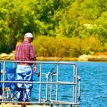
The atmosphere surrounding the lake is a blend of rich history and focused angling intensity. While the waters are famous for the "Thunder on Water" festival, the daily vibe is one of quiet determination, where serious captains navigate the submerged timber and creek channels. Unlike manicured urban fisheries, Grenada possesses a wilder character, bordered by civil war redoubts and dense bottomland hardwoods. Whether you are launching a bass boat for a tournament or setting up a heavy rig for a long weekend of trolling, understanding the logistical pulse of this Mississippi giant is the first step toward a successful haul.
Anglers traveling here will find themselves in the heart of the Mississippi hills, where the infrastructure is purpose-built for the outdoor lifestyle. The region caters heavily to the boating community, but the sheer scale of the water means that choosing the right launch point and understanding the local services can save you hours of transit time. From the high-traffic ramps near the dam to the quieter, wind-protected coves of the river arms, navigating the landside operations is just as critical as reading the depth finder.
Access & Getting There
Reaching Grenada Lake is a straightforward affair for those traveling the main arteries of the South, as the reservoir is conveniently situated along Interstate 55. For most anglers towing vessels, the primary approach involves taking the Grenada exit onto Highway 8 East. You will proceed through the city of Grenada for approximately three miles before turning left onto Scenic Loop 333. This route is generally trailer-friendly, wide enough to accommodate heavy rigs, but captains should remain vigilant for local traffic and seasonal congestion during festival weekends.
The North Abutment area serves as a primary hub for boaters, located directly on the north end of the Grenada Dam. Following Scenic Loop 333 across the dam offers a spectacular view of the water conditions before you even wet a line. However, logistical realities shift with the seasons. The water level is aggressively managed for flood control, and during the winter drawdown, the shoreline can recede as far as a mile from the summer campgrounds. This drastic fluctuation requires skippers to be acutely aware of ramp conditions; what is a deep-water launch in June may be high-and-dry mud in January.
💡 Captain's Tip: Winter Drawdown Logistics
Grenada is a flood control reservoir, meaning water levels drop significantly in winter. While some campsites face the water in summer, the shoreline can retreat up to a mile during the cold months. Always verify current ramp status and water levels before towing, as standard summer launch points may be inaccessible.
For those looking to avoid the main bustle near the dam, the North Graysport access offers a strategic alternative. Located near Gore Springs, this access point is reached by exiting I-55 on Highway 8 East and driving approximately 15 miles to the flashing light at Gore Springs. Turning left here and crossing the lake puts you in a prime position to access the distinct "V" shape of the reservoir where the rivers feed in. This area is notably quieter, positioned far enough inland to dampen the noise of heavy motorboat traffic often found near the main basin.
Parking at these facilities is generally robust, with paved aprons available at major campgrounds like North Abutment. However, during peak crappie season or the "Thunder on Water" festival in June, capacity can be tested. For those staging outside the immediate park boundaries, Truck Parking Club and 220 Truck Stop & Cafe are located roughly 12 miles away in Tillatoba, providing options for larger rigs needing a layover spot. Always ensure your vehicle and trailer are locked and secured, particularly when parking in overflow areas during high-traffic tournaments.
Grenada Lake, Mississippi Pre-Trip Checklist
Facilities & Amenities
The infrastructure surrounding Grenada Lake is tailored specifically for the needs of the dedicated angler and camper. The region supports a high caliber of specialized service providers rather than generic big-box stores. For bait and specialized tackle, the Grenada Crappie Den, located just over 6 miles from the water on Highway 8 East, is a staple for local intelligence and gear. Similarly, Reel Crappie Guides operates roughly 7 miles from the primary access points, offering both guide services and local expertise that can be invaluable for navigating the lake's shifting channels.
Accommodations in the immediate vicinity are designed to keep you close to the dawn bite. Drones Eye View RV Park is an exceptionally convenient option, located a mere 1.9 miles from the water, making it a prime base camp for those who want to minimize travel time between the bunk and the boat ramp. For anglers preferring a more solid roof, Lofts on the Square in nearby Grenada (6.7 miles away) offers high-rated lodging. If you are looking for on-water logistics, note that while there are robust camping facilities, fuel docks and heavy marine repair are less ubiquitous than on coastal fisheries, so fueling up your vessel on the highway before entering the park loops is standard procedure.
💡 Captain's Tip: Specialized Gear Sourcing
Local shops like the Grenada Crappie Den are not just retail outlets; they are information hubs. Stop in not just for minnows, but to ask about the current depth of the crappie bite. The local patterns change rapidly with water level adjustments, and the shop owners often have the most up-to-date intel.
The camping facilities managed by the Corps of Engineers are top-tier for RV anglers. North Abutment Campground is a modern facility boasting 88 RV site pads. Crucially for those running modern bass boats with heavy charging needs, these sites are equipped with 50-amp electric hookups. Sites #2 through #88 also feature sewer hookups, allowing for extended stays during the prime fishing seasons. The presence of a nearby boat ramp and pavilion makes this a central command post for many tournaments.
Alternatively, North Graysport Campground provides a slightly more secluded experience with 50 campsites, all featuring water and electric hookups, with sewer available on all sites. This campground is situated between the river arms, offering a strategic launch point for anglers targeting the river channels. Both campgrounds feature paved parking and hot showers, essential comforts after a long day exposed to the elements. Below is a detailed breakdown of the primary facility specifications:
Facility Name
Type
Capacity
Hookups
Key Amenities
North Abutment
Campground
88 RV Sites
50 Amp Electric, Water, Sewer (#2-88)
Boat Ramp, Pavilion, Amphitheater
North Graysport
Campground
50 RV Sites
50 Amp Electric, Water, Sewer (#1-50)
Boat Ramp, Hot Showers, Secluded Location
Grenada Lake Rec Area
Recreation Area
Day Use
N/A
Visitor Center, Fitness Trail, Tennis Courts
Permits, Regulations & Fees
Fishing and boating on Grenada Lake are subject to regulations managed by the State Fishing Agency and the U.S. Army Corps of Engineers. While no specific special use permit is flagged for general entry, all anglers must possess a valid Mississippi state fishing license. The importance of adherence to these regulations extends beyond legality; it is a matter of conservation for the trophy fisheries that make this lake famous. Size and creel limits, especially for crappie, are strictly enforced to maintain the quality of the stock.
Beyond the fish, the land itself holds significant historical value. The region is steeped in history, featuring an array of Civil War landmarks, including redoubts built by Confederates to fortify the Mississippi Central Railroad. These earthworks are protected cultural resources. Anglers exploring the shoreline or hiking the trails near the Visitor Center must respect these sites—digging, metal detecting, or disturbing the ground in these areas is strictly prohibited and culturally offensive.
Fee structures for camping and day use are standardized through the Recreation.gov system. Cancellations and changes to reservations at campgrounds like North Abutment and North Graysport incur service fees, typically around $10.00. Late cancellations can result in additional penalties. It is highly tailored for the reservation-based traveler, so booking your site well in advance of the spawn or the summer festival season is mandatory to secure a spot with the necessary electrical amperage for your boat.
Events & Seasonal Information
The rhythm of Grenada Lake is dictated by two major factors: the water level management cycle and the event calendar. The most significant annual event is the Thunder on Water Safe Boating Festival, held in June. This massive gathering features concerts, a youth fishing rodeo, tractor pulls, and a fireworks display. For the serious angler, this weekend represents a period of extreme on-water congestion. If your goal is solitary fishing, it is best to avoid the main harbor areas during this festival or launch from the more remote North Graysport ramps.
Seasonally, the lake transforms completely. Winter brings the drawdown, which concentrates fish but complicates navigation and access. This is often considered a prime time for experienced anglers who know how to read the exposed channels. Summer brings the full pool, opening up the flooded timber and backwater areas that are inaccessible during the colder months. The "V" shape of the lake, fed by the two rivers, creates distinct wind tunnels; when the trade winds or frontal systems push through, the main body can become treacherous, while the river arms offer sanctuary.
💡 Captain's Tip: Wind Awareness
The V-shape of Grenada Lake can funnel wind, creating surprisingly rough chop in the main basin. If the forecast calls for high winds, plan to launch at North Graysport or upstream in the river arms to utilize the land as a windbreak, rather than fighting the whitecaps near the North Abutment dam.
Contact Information & Resources
For the most accurate and up-to-date information regarding lake levels, ramp closures, and camping availability, direct communication with the managing agencies is recommended. The Grenada Lake Project Office can be reached at (662) 226-5911. For specific inquiries regarding the campgrounds, the facility line is (662) 226-1679. These numbers are your lifeline for confirming ramp usability during the transition seasons.
Safety on this water body is paramount, particularly regarding submerged structures and changing water levels. Cell service can be spotty in the deep river arms, so filing a float plan is always advised. In the event of an emergency, the local agencies are well-equipped for water rescue, but self-reliance is the mark of a professional. Ensure your vessel is equipped with all Coast Guard-required safety gear before leaving the dock.
For precise locations, real-time weather conditions, and detailed interactive maps of the boat ramps and bait shops mentioned here, consult the live dashboard and widgets below.
Our spot reports combine data-driven forecasts with curated local information. The forecast is generated by our proprietary Fishing Score algorithm (0–100%), which analyzes real-time data from Open-Meteo API, validated against NOAA CO-OPS tide gauges and USGS water-monitoring stations. The model weights tide dynamics (35%), wave energy (25%), wind patterns (20%) and time of day (20%)—factors shown to influence fish feeding behavior through marine-biology research and decades of charter log data.
Access, facilities and services information for each fishing spot is sourced from official datasets such as Recreation.gov (RIDB), state park & wildlife agencies, and geospatial providers like Google Maps. These sections undergo scheduled re-validation every 3–6 months to ensure that boat ramps, park access, contact details and local services remain accurate.
Narrative sections (catches, seasonal behavior, local tips) are synthesized from these data sources and refined following the Fishing Reports Today editorial guidelines, combining bibliographic research from ichthyology and oceanography with expert angler experience. Our team reviews reports on a regular basis, while the forecast model itself updates every 6 hours for real-time accuracy.
⚠️ Important: Always verify current local regulations, access restrictions and weather conditions before fishing. These reports are intended as a planning aid, not a guarantee of catches or safety. When in doubt, contact local authorities or park managers listed on the page.
To provide the best experiences, we use technologies like cookies to store and/or access device information. Consenting to these technologies will allow us to process data such as browsing behavior or unique IDs on this site. Not consenting or withdrawing consent, may adversely affect certain features and functions.
Functional Always active
The technical storage or access is strictly necessary for the legitimate purpose of enabling the use of a specific service explicitly requested by the subscriber or user, or for the sole purpose of carrying out the transmission of a communication over an electronic communications network.
Preferences
The technical storage or access is necessary for the legitimate purpose of storing preferences that are not requested by the subscriber or user.
Statistics
The technical storage or access that is used exclusively for statistical purposes.The technical storage or access that is used exclusively for anonymous statistical purposes. Without a subpoena, voluntary compliance on the part of your Internet Service Provider, or additional records from a third party, information stored or retrieved for this purpose alone cannot usually be used to identify you.
Marketing & Affiliates
The technical storage or access is required to create user profiles to send advertising, or to track the user on a website or across several websites for similar marketing purposes, including affiliate tracking for products recommended in our reports.
Leave a Reply