Spring has officially taken hold at Chatfield Reservoir, bringing with it fantastic open-water opportunities and rapidly warming water temperatures. The transition from the sluggish late-winter patterns to peak multi-species feeding windows is well underway. The walleye spawning operations are complete, meaning the seasonal closures near the dam have been lifted, granting anglers full access to the reservoir's 1,500 surface acres.
However, Front Range spring weather is notoriously unpredictable and demands respect. While the air temperature may feel like summer, the water temperatures are still cold enough to present a serious thermal shock hazard should you take an unexpected swim. Afternoon thunderstorms and high winds can sweep over the foothills with little warning, turning a calm surface into dangerous whitecaps in minutes. Wearing a properly fitted Personal Flotation Device (PFD) is absolutely essential for all boaters, kayakers, and float-tube anglers. Always keep one eye on the sky and monitor barometric shifts closely. If you see dark clouds cresting the foothills, it is time to head to the ramp.
🎣Nautrek
Private Beta
J
M
R
100+ anglers on the waitlist
The fishing network where your reputation matters.
Find trusted captains, join real trips with cost splitting, and build your Angler Rank. Your spots stay private — you decide who sees your intel.
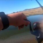
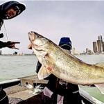
The post-spawn walleye bite is the undisputed main attraction at Chatfield right now. Having recovered from their exhausting spawning efforts, these apex predators are feeding aggressively to regain their body weight. They are currently migrating from their rocky spawning grounds toward mid-depth transition zones and shallow flats, actively hunting during low-light hours.
Sleeper Pick: Smallmouth Bass
While the majority of the boat traffic is busy trolling deep water for walleye or soaking bait for stocker trout, the smallmouth bass population offers an explosive, overlooked opportunity. These bronzebacks are heavily staging near hard-bottom structures and rocky shorelines. They are highly territorial as they prepare for their own upcoming spawn, making them incredibly susceptible to reaction strikes.
Baitfish Report
To catch the predators, you must understand the prey. The reservoir's current forage base is heavily dominated by juvenile gizzard shad, rainbow smelt, and emerging crayfish. As the water warms, crayfish are coming out of their winter dormancy, crawling along the rocky bottoms. Walleye and smallmouth bass are keying in on these specific profiles. Match the hatch by utilizing lures that mimic the erratic, darting action of a panicked smelt or the defensive, bottom-scuttling posture of a crayfish.
Tactical Strategy
Where to Deploy
To intercept feeding walleye, focus your angling efforts around the Plum Creek inlet on the southern end of the reservoir and the steep drop-offs adjacent to the swim beach on the western shore. These areas feature slightly warmer water inflows, which naturally concentrate baitfish. For smallmouth bass, target the submerged gravel pits in the southern portion of the lake and the jagged riprap along the main dam face on the north end. Work the 8-to-12-foot depth transitions where fish can easily slide up into the shallows to feed and drop back into deeper water for security.
Lure Selection
To consistently trigger strikes in these conditions, your tackle box should be equipped with the following proven profiles:
Suspending Jerkbaits: Rapala Mavrik, Rapala Husky Jerk (size HJ10), or Smithwick Rattlin' Rogue for aggressive, roaming walleye.
Jigs: 1/4oz tungsten football jigs paired with a craw-style trailer for targeting smallmouth bass tight to rocky structure.
Gliding Baits: Rapala Jigging Rap #5, which effectively mimics a dying baitfish when snapped aggressively off the bottom.
Color Patterns
Water clarity at Chatfield can vary greatly depending on the severity of the spring runoff and recent wind events. In clear water conditions, stick to natural, translucent profiles like ghost minnow, silver, and natural trout patterns. If the water is stained or murky from runoff, switch to high-visibility, UV-reflective colors like firetiger, clown, or chartreuse to help the fish locate your presentation through the gloom. For your crayfish jigs, green pumpkin and watermelon red flake are foolproof choices.
Bait and Rigging
If you prefer live bait presentations, casting 1/8oz to 1/4oz lead-head jigs tipped with a live fathead minnow is a time-tested Chatfield tactic. Trolling crawler harnesses at incredibly slow speeds (1.0 to 1.5 mph) along the emerging weedlines is also highly effective for picking off scattered walleye. For shore anglers targeting rainbow trout, soaking nightcrawlers or garlic-scented floating dough bait on a slip-sinker rig near the marina cove will yield consistent action.
Timing the Bite
The golden hours of dawn and dusk are absolutely non-negotiable for the best walleye action. As the sun rises and penetrates the clear water column, walleye will retreat to deeper, darker water and develop a severe case of lockjaw. Conversely, smallmouth bass and rainbow trout become highly active during the midday warming periods when the sun heats the shallow, rocky shorelines, activating the local insect and crayfish populations.
Pro Tip: When working suspending jerkbaits for post-spawn walleye, incorporate incredibly long pauses into your retrieval cadence. These fish can still be slightly lethargic, and they will often strike the lure out of pure instinct while it sits perfectly motionless in the water column for five to ten seconds.
Pro Tip: Pay close attention to the wind direction. A sustained breeze blowing directly into a rocky shoreline or point will push microscopic plankton into the shallows. This brings in the baitfish, which are closely followed by actively feeding predators. Always fish the windblown banks for a distinct tactical advantage.
Pro Tip: When targeting smallmouth bass around the southern gravel pits, utilize a heavy football jig to map the bottom. Drag the jig slowly to feel the composition change from soft mud to hard gravel and rock. The bass will almost always be stacked exactly on these hard-bottom transition lines.
Regulations Snapshot
Colorado Parks and Wildlife (CPW) strictly manages Chatfield Reservoir to maintain its status as a premier fishery. Ensure you are completely familiar with the current rules before launching your vessel or casting a line. Below are the critical regulations for the primary target species within the park boundaries.
Target Species
Minimum Size Limit
Daily Bag Limit
Special Park Regulations
Walleye
18 inches
3 Fish
Only one walleye exceeding 21 inches may be harvested per day.
Largemouth & Smallmouth Bass
15 inches
Statewide Aggregate
Minimum size applies to all ponds within the park and the South Platte River boundary.
Trout (Rainbow, Brown)
No Minimum
4 Fish
Standard statewide regulations apply.
Regional Alternative
If Chatfield Reservoir is blown out by dangerous high winds, or if the boat ramps are experiencing overwhelming weekend traffic, you need a reliable fallback plan to save your fishing trip. Cherry Creek Reservoir, located just a short drive to the northeast, is a fantastic alternative that offers a highly comparable multi-species experience.
Cherry Creek boasts a robust population of walleye, rainbow trout, and hard-fighting wiper. The park features excellent, expansive shore access and well-maintained boat ramps. If you make the audible to Cherry Creek, focus your tactical approach on the weedlines and submerged points near the dam. Trolling spoons or pulling bottom bouncers with crawler harnesses through the 15-to-20-foot depth range is highly effective for locating active walleye and wiper. For shore anglers, setting up near the marina cove with live bait will keep the rods bending with quality rainbow trout.
Tight lines!
Editor's Choice: Must-Have Gear
FISHINGSIR Next-Gen Waterproof Chest Waders
★★★★★4.4 (7,370+ reviews)
2-Ply Tech: Upgraded nylon with 2.5x higher density than standard fabrics.
100% Waterproof: Lab-approved intrusion resistance with taped visible seams.
Ultra-Lightweight: Designed for all-day comfort while hunting or fishing.
As an Amazon Associate I earn from qualifying purchases. #ad
Loading forecast...
Live Fishing Conditions: Tides, Weather & Waves
Get real‑time tides, marine weather, swell and solunar activity for each spot so you know exactly when conditions line up for your best chance at a bite.
🎣
Chatfield Reservoir
Loading coordinates...
🌤️
WEATHER CONDITIONS
--°F
--°C
Loading...
🌡️
Feels Like--°F--°C
💧
Humidity--%
💨
Wind-- mph-- km/h
🧭
Direction--
📊
Pressure-- inHg-- hPa
☀️
UV Index--
🌊
MARINE CONDITIONS
🌊Wave Height
-- ft
-- m
Loading...
🧭Wave Direction
--°
Loading...
⏱️Wave Period
-- s
Loading...
📈Tide Status
-- ft
-- m
Loading...
🌙
LUNAR & SOLUNAR
🌕
Loading...
Illumination: --%
Major Period--:-- - --:----:-- - --:--
Minor Period--:-- - --:----:-- - --:--
🌅Sunrise--:--
🌇Sunset--:--
📅
24-HOUR FORECAST
Loading fishing conditions...
Fishing Spots Map
🎣
Book a Fishing Charter near Chatfield Reservoir Fishing Report Today 🎣
Local guides & charters. Verified captains, instant booking, best price guaranteed.
There was an error loading the map. Please try refreshing the page.
Info
Local Access & Facilities
The South Platte Impoundment: A Strategic Overview
Situated on the South Platte River just southwest of Littleton, Chatfield Reservoir serves as a critical flood control structure that has evolved into a premier recreational fishery. Spanning 1,479 acres of surface water surrounded by over 5,000 acres of parkland, this body of water offers a diverse aquatic environment ranging from deep channels near the dam to expansive flats. The reservoir acts as the second line of defense against regional floods, creating a dynamic ecosystem where water levels can fluctuate, constantly reshaping the littoral zones that experienced anglers target.
The atmosphere here is a unique blend of suburban accessibility and rugged Front Range beauty. While the hum of the nearby highway is audible, the backdrop features the dramatic red-rock formations of the foothills and stands of Ponderosa pine and Gamble oak. It is a fishery that demands versatility, where captains must be prepared to switch from open-water trolling to working structure along the riparian edges.
For the serious angler, the draw here is the volume of water and the variety of structure. Unlike smaller municipal ponds, Chatfield provides enough acreage to run a proper center console or bass boat, allowing for the use of advanced electronics to locate schools in the main basin. The presence of the Chatfield Nature Preserve nearby ensures that water quality and environmental integrity remain high priorities for the management agencies.
Access & Getting There
Accessing the reservoir is straightforward for those familiar with the Denver Metro area, but timing is critical. The primary route involves taking C-470 to the Wadsworth Boulevard interchange. Because this is a major commuter artery, traffic can be heavy during weekday rush hours. Seasoned skippers know that towing a wide-beam boat through this corridor requires patience between 4:00 PM and 6:00 PM; a pre-dawn departure is always the superior strategy to beat the congestion.
Once inside the State Park, the launch infrastructure is robust but can get crowded. The facility features multiple launch points, with the South Boat Launch being a primary target for those looking to access the upper reaches of the reservoir quickly. The ramps are generally well-maintained concrete, suitable for larger fiberglass hulls. However, water level fluctuations managed by the Army Corps of Engineers can alter the ramp angle and traction, so inspecting the waterline before backing down is standard procedure.
💡 Captain's Tip: Trailer Management
While the South Boat Launch offers dedicated trailer parking, these spots fill rapidly on summer weekends. Plan to be at the gate when it opens, or consider a mid-week assault to ensure you have ample room to maneuver your rig without the pressure of a waiting line.
Weather on the Front Range is notoriously volatile. The reservoir is exposed to winds coming off the foothills, and conditions can shift from glass-calm to whitecaps in under 30 minutes. When the forecast calls for gusts over 15 mph, the open center of the lake becomes challenging for smaller craft. In these conditions, sticking to the leeward coves or the protected waters near the Jamison Picnic Area or Deer Creek Day Use areas is a prudent move.
Chatfield Reservoir Pre-Trip Checklist
Facilities & Amenities
While the park itself is well-equipped for recreation, anglers often need to look just outside the boundaries for specialized support. For bait and immediate tackle needs, Ken's Anglers is the closest reliable outpost, located just 3.4 miles from the water. Opening at 7:00 AM daily, it is the logical pitstop for live bait and local intelligence before hitting the ramp. For more extensive gear requirements, Discount Fishing Tackle on South Santa Fe Drive (approx. 9.9 miles away) offers a broader selection of hard goods.
Fly fishermen targeting the river inlets or shallows should note the presence of The Confluence Rod Company and Fly Fish Colorado in the wider region. These resources indicate a healthy local culture of fly angling, suggesting that the reservoir's tributaries and flats hold potential for those willing to wield a long rod. If you are looking to hire local knowledge, River Trekker Outfitters operates in the area, providing guided expertise that can cut the learning curve significantly.
💡 Captain's Tip: Fuel Logistics
There is no dedicated fuel dock listed explicitly for the launch areas in the immediate facility data. Captains should operate under the assumption that they need to fuel up on the highway before entering the park. Running dry on 1,400 acres of water is a mistake you only make once.
For multi-day excursions, on-site options are available but geared towards camping. The Indian Creek Equestrian Campground, located about 10.4 miles away, offers a rustic base camp, particularly for those who might be combining angling with packing in on horseback. This facility provides gravel driveways and is strictly for those in possession of a horse, so standard boat-camping anglers should look to the main park campgrounds or nearby accommodation like the NYR-Nationwide Youth Roundup facility for lodging.
Permits, Regulations & Fees
Navigating the regulatory environment at Chatfield requires attention to both state and federal rules. As a State Park leasing land from the Army Corps of Engineers, the area is managed strictly to balance recreation with flood control and conservation. A valid State Parks pass is typically required for vehicle entry, in addition to any vessel registration fees. Fishing activities fall under the jurisdiction of the state fishing agency, and officers patrol both the gates and the water frequently.
Conservation zones are a critical aspect of this fishery. The Chatfield Nature Preserve is a sensitive area dedicated to environmental study. Anglers must respect all buoy lines and signage demarcating restricted zones. These areas act as nurseries and sanctuaries for the bird populations and aquatic life that sustain the fishery. Ignorance of a "No Wake" or "Exclusion Zone" marker is not a valid defense here.
Cultural respect is also paramount. The Hildebrand Homestead, listed on the National Register of Historic Places, is located within the vicinity. While primarily a land-based attraction, its presence serves as a reminder of the historical significance of the South Platte valley. Anglers utilizing the shoreline access points near Deer Creek should be mindful of leaving no trace to preserve the integrity of these public lands.
Events & Seasonal Information
The reservoir operates as a year-round fishery, though the tactics change drastically with the seasons. Summer brings heavy recreational boat traffic—wakeboarders and jet skis—which forces serious anglers to adjust their clocks. The "Dawn Patrol" is essential from June through August; the best fishing window is often closing just as the recreational fleet is launching at 10:00 AM. Conversely, the shoulder seasons of late fall and early spring offer solitude and often the most aggressive feeding windows as fish prepare for or recover from winter.
💡 Captain's Tip: Wind Patterns
Local skippers watch the flags. The typical weather pattern involves calm mornings followed by afternoon thunderstorms rolling off the mountains. If you see towering cumulus clouds building over the foothills to the west, it is time to pull the trolling motor and head for the ramp immediately.
While specific tournament schedules vary annually, the size and accessibility of Chatfield make it a frequent host for local club derbies and regional competitive circuits. These events usually launch from the main ramps at first light. If you are not competing, check the local boards or ask at Ken's Anglers about scheduled events to avoid the congestion of a 50-boat blast-off.
Contact Information & Resources
For the most current information regarding water levels, ramp closures, or emergency alerts, direct contact with the managing agencies is recommended. The regional ranger district can be reached at 303-275-5610. This line is particularly useful for checking on conditions at the Indian Creek area or general forest service notices that might impact the watershed.
Safety on the water is the responsibility of the captain. Cell reception is generally good across the reservoir due to its suburban proximity, but dead zones can exist in the deep channels near the dam. Always file a float plan and ensure your safety gear exceeds the minimum Coast Guard requirements.
For precise locations of the boat ramps, real-time weather data, and detailed locations of the tackle shops mentioned above, consult the live dashboard and interactive maps below.
🎣
Chatfield Reservoir
Littleton • Colorado • 39.5396, -105.0782
🅿️
Parking
5
Paradise Parking Lot
⭐ 5.013.8 mi
📍Parking lot, 1420 Garrison St #2, Lakewood, CO 80215, USA
Our spot reports combine data-driven forecasts with curated local information. The forecast is generated by our proprietary Fishing Score algorithm (0–100%), which analyzes real-time data from Open-Meteo API, validated against NOAA CO-OPS tide gauges and USGS water-monitoring stations. The model weights tide dynamics (35%), wave energy (25%), wind patterns (20%) and time of day (20%)—factors shown to influence fish feeding behavior through marine-biology research and decades of charter log data.
Access, facilities and services information for each fishing spot is sourced from official datasets such as Recreation.gov (RIDB), state park & wildlife agencies, and geospatial providers like Google Maps. These sections undergo scheduled re-validation every 3–6 months to ensure that boat ramps, park access, contact details and local services remain accurate.
Narrative sections (catches, seasonal behavior, local tips) are synthesized from these data sources and refined following the Fishing Reports Today editorial guidelines, combining bibliographic research from ichthyology and oceanography with expert angler experience. Our team reviews reports on a regular basis, while the forecast model itself updates every 6 hours for real-time accuracy.
⚠️ Important: Always verify current local regulations, access restrictions and weather conditions before fishing. These reports are intended as a planning aid, not a guarantee of catches or safety. When in doubt, contact local authorities or park managers listed on the page.
To provide the best experiences, we use technologies like cookies to store and/or access device information. Consenting to these technologies will allow us to process data such as browsing behavior or unique IDs on this site. Not consenting or withdrawing consent, may adversely affect certain features and functions.
Functional Always active
The technical storage or access is strictly necessary for the legitimate purpose of enabling the use of a specific service explicitly requested by the subscriber or user, or for the sole purpose of carrying out the transmission of a communication over an electronic communications network.
Preferences
The technical storage or access is necessary for the legitimate purpose of storing preferences that are not requested by the subscriber or user.
Statistics
The technical storage or access that is used exclusively for statistical purposes.The technical storage or access that is used exclusively for anonymous statistical purposes. Without a subpoena, voluntary compliance on the part of your Internet Service Provider, or additional records from a third party, information stored or retrieved for this purpose alone cannot usually be used to identify you.
Marketing & Affiliates
The technical storage or access is required to create user profiles to send advertising, or to track the user on a website or across several websites for similar marketing purposes, including affiliate tracking for products recommended in our reports.


Leave a Reply