


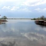
Prewitt Reservoir sits as a quiet, stoic challenger on the high plains of Colorado, offering a fishing experience that is as much about solitude as it is about the catch. Unlike the manicured, high-traffic impoundments found closer to the Front Range, this location demands a level of self-sufficiency and logistical planning that seasoned anglers often appreciate. The atmosphere here is defined by the vast, open horizon of Beta, where the silence is usually broken only by the wind or the drag of a reel. It is a fishery that rewards those willing to venture off the beaten path, far removed from the neon glare of urban tackle shops and crowded marinas.
For the expert angler, this reservoir represents a classic plains fishery. The topography is generally subtle, requiring a keen eye for bottom structure and water temperature changes rather than visible shoreline cover. The water here can be deceptive; calm mornings often give way to the rugged, shifting conditions characteristic of Eastern Colorado. It is a place where the "dawn patrol" isn't just a strategy—it is a necessity to beat the inevitable afternoon gusts. The isolation here is the primary amenity, attracting those who prefer to stalk game fish without bumper boats interfering with their drift.
Successfully fishing Prewitt Reservoir requires a mindset shift from convenience to preparation. With major services located miles away, your vehicle becomes your base camp, tackle shop, and galley. The following guide breaks down the essential logistics, from navigating the rural access roads to identifying the few but critical facilities available to support your expedition. This is rugged, unpretentious water, and understanding the lay of the land is the first step toward a productive day on the bank or the boat.
Access & Getting There
Reaching Prewitt Reservoir involves navigating the open stretches of Colorado plains, a drive that can be deceptively simple until weather interferes. The primary approach is typically via the highway systems connecting Sterling and Fort Morgan. Traffic in this region is generally light, dominated by agricultural transport rather than commuter congestion. However, anglers towing center consoles or heavy fiberglass hulls should be mindful of crosswinds on the exposed highways. The route is paved, but the final approach roads can vary in quality depending on recent weather events.
💡 Captain's Tip: Wind Windows
The high plains are notorious for sudden wind shifts. seasoned skippers know that if the forecast predicts gusts over 15 mph by noon, the launch window closes at 11:00 AM. Plan your arrival for first light to maximize fishable hours before the chop becomes unmanageable.
Access to the water is primarily defined by shoreline entry points rather than elaborate marina complexes. The data indicates specific shore access zones suitable for families and foot anglers at coordinates roughly 40.48 latitude. These points are essential for those without watercraft, offering direct access to the water's edge. While specific improved boat ramps are not detailed in the immediate dataset, the "shore access" designation often implies dirt or gravel transitions where kayaks and light craft might be launched, though heavy trailered boats should proceed with caution and verify current water levels visually before committing to a launch.
Parking near the water is rustic. Unlike urban reservoirs with paved lots and designated trailer stalls, you are likely dealing with gravel pull-offs or designated dirt areas. The nearest structured, commercial parking facility is the Truck Parking Club in Atwood, located approximately 7.9 miles away. This is a critical logistical point for anglers hauling large rigs who may need a secure place to stage or rest before hitting the water, especially given the lack of immediate facilities right at the reservoir's edge.
Weather contingencies are the most critical aspect of access here. In the event of heavy rains, the soil in this region—often a mix of clay and loam—can become incredibly slick, making unpaved access roads treacherous for 2WD vehicles. If a summer storm rolls in, the prudent move is to head toward the paved artery of the main highway rather than risking a slide on a muddy backroad. Always have a recovery strap and a shovel in the truck bed; self-rescue is often the only rescue available in a timely manner.
Prewitt Reservoir Fishing Report Today 🎣 Pre-Trip Checklist
Facilities & Amenities
The infrastructure surrounding Prewitt Reservoir is sparse, forcing anglers to rely on the nearby hubs of Sterling and Fort Morgan for serious provisioning. There is no on-site marina, fuel dock, or tackle shop listed directly at the reservoir. This "negative knowledge" is vital: you must arrive with full fuel tanks, full bait buckets, and enough ice to last the duration of your trip. The nearest specialized services are significant distances away, meaning a forgotten drain plug or empty cooler can end a trip before it begins.
For accommodation, the standout option for anglers looking to stay close to the action is Sterling RV Park-The Landing. Located roughly 15 miles from the fishing grounds, this facility boasts a high rating of 4.7 stars. It is the logical base of operations for multi-day trips, offering a place to recharge batteries and rest rigging after a long day on the water. For those preferring a standard hotel room, MoJo's Inn in Akron (19.8 miles) and the Best Western Plus Overland Inn in Fort Morgan (24 miles) provide reliable lodging, though they require a longer pre-dawn commute.
💡 Captain's Tip: The Supply Gap
There are zero bait shops or fuel stations listed within the immediate vicinity of the water. Top off your gas tank in Sterling or Fort Morgan. If you run live bait, ensure your aeration system is robust, as you cannot simply buy more minnows at the ramp.
Restroom facilities are another logistical challenge. The data indicates public restrooms are located approximately 16.9 miles away, likely associated with the Sterling Rest Area. This implies that the reservoir itself may lack maintained sanitary facilities, or they are primitive at best. Anglers taking families or clients should plan accordingly, utilizing facilities in town before making the final drive to the water. The Sterling Rest Area also serves as a safe, well-lit location for rigging checks or meeting up with fishing partners coming from different directions.
The table below details the primary logistical hubs available to anglers in the region:
| Facility Name | Type | Distance | Details |
|---|---|---|---|
| Sterling RV Park-The Landing | Accommodation | 15.0 miles | Rated 4.7 stars. Ideal for RVs and trailers. Open 24 hours. |
| Truck Parking Club | Parking | 7.9 miles | Located in Atwood. Secure parking option for large rigs. |
| Sterling Rest Area | Restroom / Parking | 16.9 miles | Public restrooms and staging area. Rated 4.1 stars. |
| MoJo's Inn | Accommodation | 19.8 miles | Located in Akron. Rated 4.6 stars. |
| Best Western Plus Overland Inn | Accommodation | 24.0 miles | Located in Fort Morgan. Rated 4.6 stars. |
Permits, Regulations & Fees
Fishing at Prewitt Reservoir falls under the jurisdiction of the State Fishing Agency. Compliance here is not just about avoiding fines; it is about maintaining the delicate balance of a high-pressure plains fishery. While specific permit prices are subject to seasonal change, anglers should expect to carry a valid Colorado state fishing license. Electronic licenses on smartphones are generally accepted, but given the spotty cellular reception in rural basins, carrying a printed copy in a waterproof bag is a professional best practice.
Because the reservoir is surrounded by agricultural land—evidenced by the presence of major industry players like Cargill in the broader region—respect for property boundaries is paramount. The "Kapu" or forbidden zones often include private fences bordering the public access areas. Crossing private land to reach a "honey hole" is the fastest way to get access shut down for everyone. Stick to the designated shoreline access points identified on the map and respect all "No Trespassing" signage strictly.
Conservation in this area focuses on sustaining game fish populations amidst fluctuating water levels. Bag limits and size restrictions are strictly enforced to ensure the fishery remains viable through drought cycles. It is also critical to inspect your hull and boots for invasive species. As a reservoir that likely feeds into or from agricultural irrigation systems, introducing aquatic nuisance species can have devastating economic and ecological consequences for the entire county.
Events & Seasonal Information
The fishing calendar at Prewitt Reservoir is dictated by the harsh continental climate of the plains. The "season" is effectively split into two distinct phases: the open water season and the hard water (ice) season. Spring typically brings the most aggressive feeding windows as water temperatures rise and fish move shallow. This is the time when the shoreline access points are most productive, allowing bank anglers to reach active fish without a boat.
Summer brings heat and algae. As the ambient temperature in Beta climbs, the bite often shifts to low-light periods. Experienced locals know that the midday sun can shut down activity completely. During these months, the "night shift" becomes popular, with anglers targeting catfish or walleye under the cover of darkness. The wind is also a major seasonal factor; the transitional months of spring and fall often see the highest wind speeds, making boat control difficult.
💡 Captain's Tip: Seasonal Access
In late summer, water levels in plains reservoirs can drop significantly due to irrigation demand. This can leave boat ramps high and dry and extend the mudflats at shore access points. Always check the current water level report before hauling a heavy boat.
While no specific major tournament series is listed in the immediate dataset for this exact location, the proximity to Sterling suggests that local clubs likely utilize this water. Competitive anglers should keep an eye on local forums for club derbies, which can crowd the limited access points on weekends. Conversely, winter ice fishing is a staple in this region, provided the ice cap is stable. The solitude of the frozen reservoir offers a completely different, yet equally rewarding, experience.
Contact Information & Resources
For the most current conditions, anglers should rely on the State Fishing Agency resources. In the absence of an on-site harbor master, safety is entirely the responsibility of the captain. There is no dedicated water rescue team stationed at the reservoir; emergency response would likely deploy from Sterling or Fort Morgan, meaning help is at least 30 minutes away. Cell service can be intermittent in low-lying areas of the reservoir, so filing a float plan with someone on land is standard operating procedure.
For immediate medical emergencies, the nearest major services would be in the population centers of Sterling or Fort Morgan. Ensure your first-aid kit is stocked and your vehicle is reliable. This is a location that rewards self-reliance and punishes unpreparedness. For precise locations of the shore entry points, parking areas, and real-time weather data, consult the live dashboard and interactive maps below.


Leave a Reply